info@shustrik-maps.com

Contact me


    Free conversion to OBJ/FBX/STL/C4D
    • Services
    • About
    • FAQ
    • Site Map
    • How to buy?
    info@shustrik-maps.com

    Contact me


      Logo shustrik maps
      • 3D MODELSOBJ/FBX/C4D
        • Solar System

          3D MODELS OF SOLAR SYSTEM OBJECTS

          Planets (11)

          11 products

          Satellites (1)

          1 product

          Space objects (3)

          3 products
        • World

          World (8)

          8 products

          North Pole (1)

          1 product

          South Pole (1)

          1 product

          Fantasy (2)

          2 products
        • Continents

          North America (2)

          2 products

          South America (2)

          2 products

          Europe (2)

          2 products

          Asia (1)

          1 product

          Africa (2)

          2 products

          Oceania (3)

          3 products

          Antarctica (1)

          1 product
        • Peninsulas

          Peninsulas (1)

          1 product
        • Islands

          Islands (13)

          13 products
        • Countries

          All countries →

          3D MODELS OF THE COUNTRIES

          A | B | C | D | E | 

          F | G | H | I | J | 

          K | L | M | N | O | 

          P | Q | R | S | T | 

          U | V | W | Y | Z | 

          3D MODELS OF COUNTRIES BY CONTINENT

          NORTH AMERICA

          • Northern America
          • Central America
          • Caribbean

          SOUTH AMERICA

          EUROPE

          • Western Europe
          • Northern Europe
          • Southern Europe
          • Eastern Europe

          AFRICA

          • Eastern Africa
          • Middle Africa
          • Northern Africa
          • Southern Africa
          • Western Africa

          ASIA

          • Central Asia
          • Eastern Asia
          • Southeast Asia
          • Southern Asia
          • Western Asia
        • States of America

          All states →

          UNITED STATES 3D MODELS

          Alabama

          • C4D/OBJ/BLEND 
          • STL
          • Satellite Map

          Alaska

          • STL


          Arizona

          • C4D/OBJ/BLEND 
          • STL
          • Satellite Map

          Arkansas

          • C4D/OBJ/BLEND 
          • STL
          • Satellite Map

          California

          • Tex 1: C4D/OBJ
          • Tex 2: C4D/OBJ
          • STL
          • Satellite Map

          Colorado

          • C4D/OBJ/BLEND
          • STL
          • Satellite Map

          Connecticut

          • STL
          • Satellite Map

          Delaware

          • STL
          • Satellite Map

          Florida

          • C4D/OBJ/BLEND
          • STL
          • Satellite Map

          Georgia

          • STL
          • Satellite Map

          Hawaii

          • C4D/OBJ/BLEND
          • STL


          Idaho

          • C4D/OBJ/BLEND
          • STL
          • Satellite Map

          Illinois

          • STL
          • Satellite Map

          Indiana

          • C4D/OBJ/BLEND
          • STL
          • Satellite Map

          Iowa

          • C4D/OBJ/BLEND
          • STL
          • Satellite Map

          Kansas

          • C4D/OBJ/BLEND
          • STL
          • Satellite Map

          Kentucky

          • STL
          • Satellite Map

          Louisiana

          • STL
          • Satellite Map

          Maine

          • STL
          • Satellite Map

          Maryland

          • STL
          • Satellite Map

          Massachusetts

          • STL
          • Satellite Map

          Michigan

          • STL

          Minnesota

          • STL


          Mississippi

          • STL

          Missouri

          • STL

          Montana

          • Tex 1: C4D/OBJ
          • Tex 1: C4D/OBJ
          • STL

          Nebraska

          • C4D/OBJ/BLEND
          • STL


          Nevada

          • C4D/OBJ/BLEND
          • STL


          New Hampshire

          • STL


          New Jersey

          • STL

          New Mexico

          • C4D/OBJ/BLEND
          • STL

          New York

          • STL


          North Carolina

          • STL

          North Dakota

          • C4D/OBJ/BLEND
          • STL

          Ohio

          • STL


          Oklahoma

          • STL

          Oregon

          • C4D/OBJ/BLEND
          • STL

          Pennsylvania

          • STL


          Rhode Island

          • STL

          South Carolina

          • STL

          South Dakota

          • C4D/OBJ/BLEND
          • STL

          Tennessee

          • STL


          Texas

          • C4D/OBJ/BLEND
          • STL

          Utah

          • C4D/OBJ/BLEND
          • STL


          Vermont

          • STL


          Virginia

          • STL

          Washington

          • C4D/OBJ/BLEND
          • STL

          West Virginia

          • STL


          Wisconsin

          • STL

          Wyoming

          • C4D/OBJ/BLEND
          • STL
        • Canadian Provinces

          CANADIAN PROVINCES 3D MODELS

          Alberta

          British Columbia

          Manitoba

          New Brunswick

          Newfoundland

          Nova Scotia

          Ontario

          Prince Edward

          Quebec

          Saskatchewan

          CANADIAN TERRITORIES 3D MODELS

          Northwest Territories

          Nunavut

          Yukon

        • Parks & Canyons

          3D MODELS OF NATIONAL PARKS AND CANYONS

          Canyons (2)

          2 products
        • Other

          ART (4)

          4 products
      • 3D PRINT/CNC MODELSSTL
        • Planets
        • Satellites
        • Continents
        • Countries
        • Islands
        • States of America
        • Fantasy
        • Other
      • MAPSTIF/PSD/SVG
        • Satellite Maps
        • Night Satellite Map
        • Heightmaps/Raster DEM
        • Relief Maps
        • 3D Maps
        • Historical Maps
        • Outline Maps
      • FREE
      • SERVICES
      • A-Z
      Search
      0 items / $0.00
      Menu
      3D Models and 3D Maps
      0 items / $0.00
      World Earth Map 3D Overview
      Flat 3D map of Earth with detailed landforms and accurate geographic features.
      3d model world map
      Close-up of elevation models on the flat 3D world map.
      Geospatial data represented in the World Earth Map 3D with detailed geographic accuracy.
      world 3D model terrain
      world buy 3d models
      world map 3d model
      world 3D map
      world relief map
      High-resolution satellite imagery displayed in the World Earth Map 3D model.
      Topographic map world
      world 3d model without water
      world 3D model in C4D format
      3D relief map of the world
      world 3d mode mesh
      Click to enlarge
      World Earth Map 3D Overview
      Flat 3D map of Earth with detailed landforms and accurate geographic features.
      3d model world map
      Close-up of elevation models on the flat 3D world map.
      Geospatial data represented in the World Earth Map 3D with detailed geographic accuracy.
      world 3D model terrain
      world buy 3d models
      world map 3d model
      world 3D map
      world relief map
      High-resolution satellite imagery displayed in the World Earth Map 3D model.
      Topographic map world
      world 3d model without water
      world 3D model in C4D format
      3D relief map of the world
      world 3d mode mesh
      Home 3D MODELS World World Earth Map 3D Model
      Minecraft Bee 3D Model
      Minecraft Bee 3D model $7.00
      Back to products
      Mercury Planet 3D Model
      Mercury Planet 3D Model $20.00 Original price was: $20.00.$15.00Current price is: $15.00.

      World Earth Map 3D Model

      $35.00

      World Earth Map 3D – A Detailed 3D Model of the Earth

      • Format: C4D/OBJ (on request)
      • File size (unzipped): 572 MB
      • Polygons: 9 988 760
      • Vertices: 4 999 122
      • Geometry: Polygonal Tris only
      • Model size: 2812.5 mm x 1406.25 mm x 21.801 mm
      • Projection: Geographic
      • Base: Open

      Textures

      • Height Map TIF 16348*8197*16b – You can use this map in the displacement channel instead of the polygonal mesh
      • Normal Map TIF 16348*8197*48b – Use this map to reveal fine details of the relief
      • Satellite Map TIF 22500*11250*24b
      • Water Map TIF 22500*11250*32b
      • Pseudo-color Map 22500*11250*24b – Use this map to get elevation information based on the color shade
      • Boundary Mask TIF 22500*11250*24b – Use this map as a mask for your background

      We accept VISA, Mastercard, ApplePay, GooglePay and other payment methods

      — OR —

      You can also purchase this product using MasterCard/Visa on
      RenderHub →  and 3Dexport →.

      SKU: SH_3484 Category: World Tags: 3D model, C4D
      Share:
      • Description
      Description

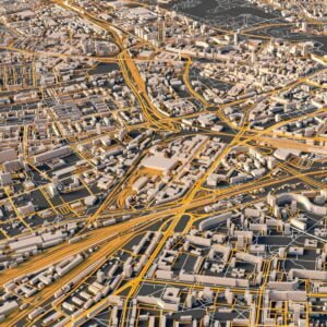
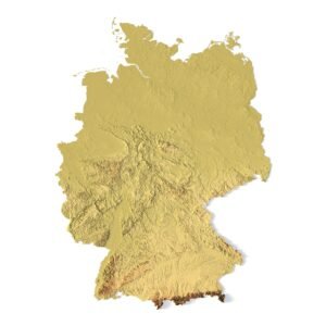
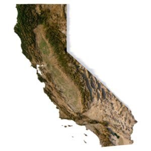
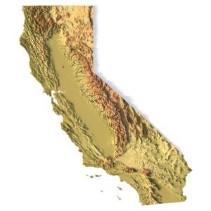
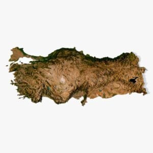
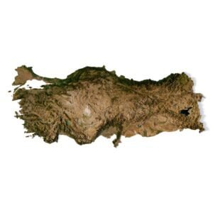
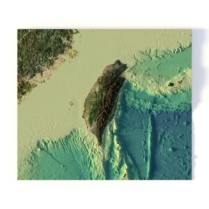
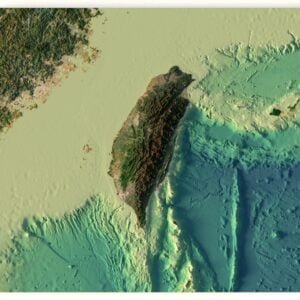
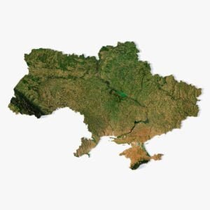
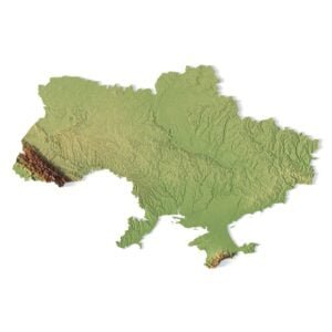
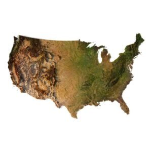
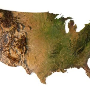
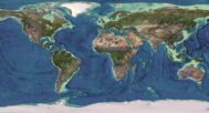
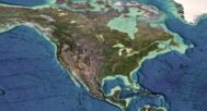
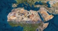
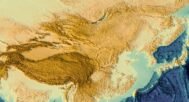
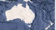
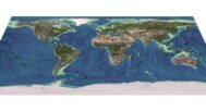
      The World Earth Map 3D is a comprehensive, high-resolution model of the Earth in 3D. This stunning digital representation features precise topographic details and landforms in an interactive format. It’s perfect for architects, designers, and educators seeking a realistic and detailed view of the world’s geography, without the need for a traditional globe.

      Explore a Flat 3D Earth Map with Exceptional Detail

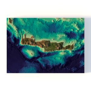
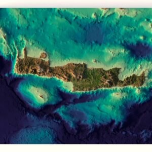
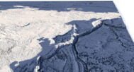
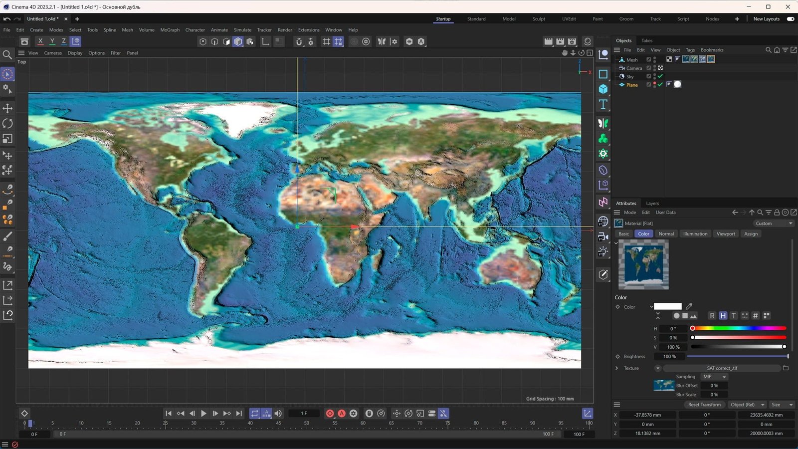
      Unlike a globe, this 3D world map presents the Earth in a flat yet fully interactive format, ideal for visualizing latitude and longitude, elevation models, and geographic features across continents and oceans. You can examine each country and terrain with accurate topographical and cartographic precision.

      High-Resolution Satellite Imagery and Topography

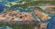
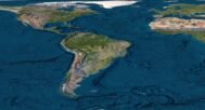
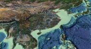
      The World Earth Map 3D utilizes satellite imagery and elevation data to create an engaging and educational 3D experience. The map includes detailed landforms, mountain ranges, valleys, and more, allowing users to explore the Earth’s diverse geography with realistic depth and clarity.

      Perfect for 3D Visualization and Mapping Applications

      Whether you’re working on a professional geospatial data project or looking for an engaging way to teach cartography, this model offers an exceptional tool for 3D visualization. Zoom in to explore terrain, water bodies, and geographic borders with ease, making it a versatile asset for any project.

      Key Features of the World Earth Map 3D Model

      • High-resolution 3D visualization of Earth’s surface in a flat layout
      • Accurate topographic features such as mountains, valleys, and plateaus
      • Realistic satellite imagery for added detail and accuracy
      • Detailed cartographic representation of countries, continents, and bodies of water

      The Best World Earth Map 3D for Visualization Projects

      This 3D world map model is perfect for anyone looking to add a realistic Earth visualization to their projects. Ideal for educators, designers, and geographers, the World Earth Map 3D provides an immersive look at the world’s surface, suitable for both educational and professional applications.

      world C4D OBJ

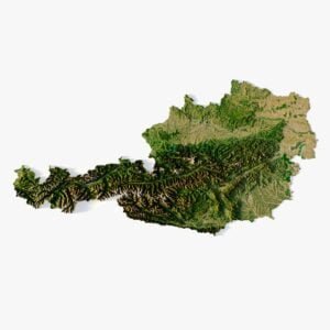
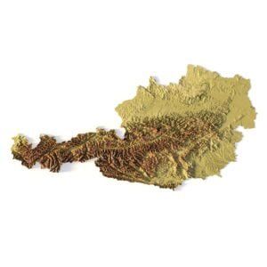
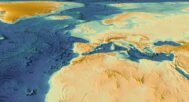
      In addition to the 3D terrain model of the World, I can attach a map of heights and various satellite textures.
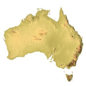
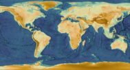
      World DEM

      world DEM

      The elevation map is used to get information about low and high parts of the World relief.

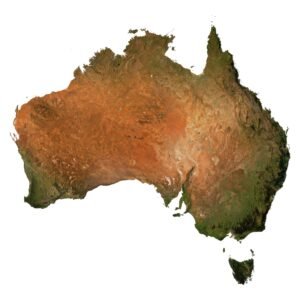
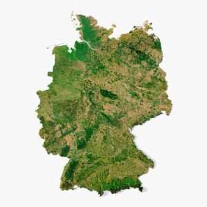
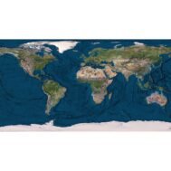
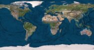
      Satellite image of World

      world 3d texture satellite

      The satellite texture is high resolution in TIF format.
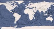
      World Normal Map

      world normal map

      Use this map to reveal fine details of the relief.

      Have a Question?

      Do you need an extra high resolution 3D terrain of the World?
      Do you require Shapefile?
      Do you require more resolution satellite images?
      Do you require a 3D models in BLEND, OBJ, FBX or STL format?
      WRITE A MESSAGE
      World Map Dymaxion 3D
      Earth 3D model Terrain Without Water

      Related products

      Australia 3D model
      Australia stl files for 3d printing

      Australia Relief Map 3D model

      $28.00
      Add to cart
      -33%
      Crete 3D model
      Crete terrain 3D model

      Crete terrain without water 3D model

      $30.00 Original price was: $30.00.$20.00Current price is: $20.00.
      Add to cart
      -27%
      Minsk City 3D model

      Minsk City 3D model

      $10.00 Original price was: $10.00.$7.30Current price is: $7.30.
      Add to cart
      Austria STL model
      3D STL model of Austria’s topography, showcasing elevation data and geographical features, perfect for 3D printing and terrain analysis.

      Relief map of Austria 3D model

      $28.00
      Add to cart
      Germany terrain
      Germany model C4D OBJ STL

      Relief map of Germany 3D model

      $28.00
      Add to cart
      -33%
      California 3D model
      California buy 3d models

      Relief map of the state of California 3D model

      $30.00 Original price was: $30.00.$20.00Current price is: $20.00.
      Add to cart
      Turkey terrain 3D model
      Turkey 3D model

      Relief map of Turkey 3D model

      $28.00
      Add to cart
      -33%
      Taiwan terrain 3D model
      Taiwan 3D model

      Taiwan 3D terrain without water

      $30.00 Original price was: $30.00.$20.00Current price is: $20.00.
      Add to cart
      Ukraine 3D model
      Ukraine 3D model

      Ukraine map 3D model

      $28.00
      Add to cart
      USA 3D map model showcasing elevation and topographic details.
      USA map in 3D with elevation, normal maps, and satellite textures.

      USA map 3D model

      $28.00
      Add to cart
        INFO
        • About
        • Explore Our Terrain Services
        • Support
        • Shipping and delivery policy
        • Refund and Returns Policy
        • Privacy Policy
        • in**@***********ps.com
        • Blog
        How to buy
        • TERRAIN 3D MODELS FREE
        • Purchase with Crypto/PayPal/VISA
        • Buy on Cults3D.com
        • Buy on CGtrader.com
        • Buy on RenderHub.com
        • Buy on 3DExport.com
        • Discounts
        Buy 3D models
        • Planets
        • World
        • Continents
        • Peninsulas
        • Islands
        • Countries
        • States of America
        • Canadian Provinces
        • Canyons
        • Cities
        • Fantasy
        • Minecraft
        Buy 3D models for CNC
        • Planets
        • Continents
        • Islands
        • Countries
        • States of America

        DEM DSM DTM FBX OBJ STL

        SHUSTRIK-MAPS 2025
        • 3D MODELS
          • Solar System
          • World
          • Continents
          • Peninsulas
          • Islands
          • Countries
          • States of America
          • Canadian Provinces
          • Canyons
          • Buildings
          • Fantasy
          • ART
        • 3D PRINT/CNC MODELS
          • Planets
          • Satellites
          • Continents
          • Countries
          • Islands
          • States of America
          • Fantasy
          • Other
        • MAPS
        • A-Z
        • FREE
        • About
        • FAQ
        • How to buy?
        • Site Map HTML
        • Explore Our Terrain Services
        Shopping cart
        Close
        Start typing to see products you are looking for.
        Your amount to pay has been updated
        The previous conversion quote has expired. Here is your new quote:
        Total
        $
        You Pay
        Back to checkout
        Place Order