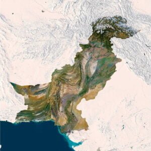
Maine Satellite Map
$15.00
Maine satellite imagery for editorial maps, presentations and print design.
- Format: TIF
- Resolution: 10741*15174 px
- Depth: 24 bit
- Size: 202 MB
- Color scheme: RGB
- Projection: Mercator
The Maine satellite map highlights a largely green state outline beside the dark blue Atlantic. Numerous blue lakes interrupt the inland landscape, while the southern and eastern shoreline breaks into bays, headlands and offshore islands. The image’s tall form connects these coastal and inland settings.
A darker surrounding frame keeps the irregular northern and western edges visible without removing the adjoining landscape. The interior has a comparatively continuous green appearance, contrasted by water bodies and small pale surface patterns. Along the coast, the increasing detail of the land-water boundary becomes a separate visual feature.
Use it for Maine presentations, northern New England editorial maps and printed coastal graphics. The combination of lakes, inland greenery and a deeply indented shoreline gives projects more specific geographic material than a simple state silhouette.
FAQ
This map is not geo-referenced, but feel free to contact us to obtain a file with geo data if needed.
Yes, we offer custom projections upon request. Contact us for details.
Yes, if you need the map in a different file format, please contact us. We offer various formats to meet your needs.
Yes, of course. Please specify the desired 3D model format, dimensions and how you will use it. This will help me to prepare an optimal model for you.
Absolutely! If you require a higher resolution version, just let us know, and we can provide a version that fits your requirements.
Yes, we can customize the map with different projections or remove boundaries as needed. Please reach out to us with your specifications, and we’ll accommodate your request.
For custom sizes or additional features, please contact us directly. We are happy to work with you to create a tailored map that fits your specific needs.
Absolutely! The map is available in high resolution, making it suitable for large format printing without losing detail. Be sure to check with your printing company if they require RGB-to-CMYK color conversion for best results.
In addition to educational and decorative uses, the map can be utilized for trip planning, natural resource research, and as a creative gift.
Related products