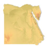
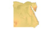
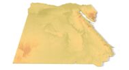
Egypt Topographic Map – 3D Model for 3D Printing & CNC Carving
$15.00
High-polygon 3D model of Egypt in STL format
![]()
- File size: 161 MB
- Model size: 220 mm х 212 mm х 2.2 mm
- Projection: Mercator
- Scaling factor: X — 0,001; Y — 0,001; Z — 0,005
- Polygons: 2 051 594
- Vertices: 1 025 900
- Geometry: Polygonal Tris only
- Base: Closed
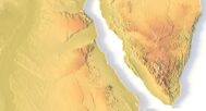
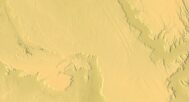
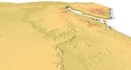
The Egypt Topographic Map is a high-resolution 3D terrain model based on an accurate digital elevation model (DEM). It faithfully captures Egypt’s dramatic landscapes, including the Nile River Valley, Sahara Desert dunes, Red Sea mountains, and oasis depressions, making it ideal for archaeologists, educators, designers, and history enthusiasts.
This STL file is fully compatible with FDM and SLA 3D printers, as well as CNC routers. You can 3D print a realistic map of Egypt in plastic or carve it from wood, stone, or metal. It’s perfect for educational models, archaeological reconstructions, souvenir production, and terrain visualization.
This model is a striking addition to classrooms, museums, architectural projects, or historical exhibits. With precise elevation details and optimized geometry, it ensures professional results whether printed small or large.


Why choose this model:
✔ Realistic Topography Based on Geospatial Data
Uses NASA/SRTM elevation data for accurate representation of Egypt’s deserts, Nile Delta, and mountainous regions.
✔ Ready for 3D Printing & CNC Machining
Clean, manifold STL file works with PLA, resin, wood, or metal. Scalable for tabletop displays or large wall art.
✔ Ideal for Education & Cultural Projects
Great for teaching geography, ancient history, or creating Egypt-themed decor and gifts.
Sample Use Cases:
3D print a raised-relief map of Egypt for history/geography classes
CNC carve the Nile Valley and pyramids into wood or stone for museum displays
Create desert terrain layouts for architectural or archaeological models
Produce Egypt-themed wall art or souvenir keychains
Design custom jewelry with Egypt’s topography