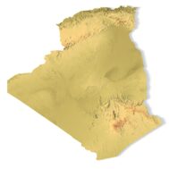
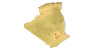
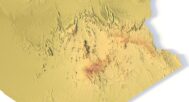
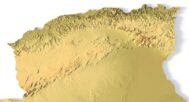
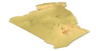
Algeria Topographic Map – 3D Model for 3D Printing & CNC Carving
$15.00
High-Resolution Algeria Topographic Map STL File
![]()
- File size: 123 MB
- Model size: 200 mm х 200 mm х 2.8 mm
- Projection: Mercator
- Scaling factor: X — 0,001; Y — 0,001; Z — 0,003
- Polygons: 2 596 826
- Vertices: 1 298 415
- Geometry: Polygonal Tris only
- Base: Closed
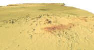
This Algeria Topographic Map is a professionally crafted 3D terrain model based on digital elevation data, ideal for FDM and SLA 3D printing, as well as CNC carving. Whether you’re working on terrain modeling, geospatial visualization, or educational mapping projects, this STL file provides unmatched accuracy and detail.
With authentic contour lines, elevation mapping, and realistic surface geometry, the Algeria terrain model is perfect for professionals in geographic information systems (GIS), educators, designers, and makers.
Applications of the Algeria Topographic STL Model
3D Printing: Create physical models of Algeria’s diverse terrain using FDM or SLA 3D printers, showcasing the country’s elevation data, from the Sahara Desert to the Atlas Mountains.
CNC Machining: Perfect for crafting detailed relief maps from wood or metal, this model provides precise topographic details for professional design, geographic analysis, and architectural projects.
Laser Engraving: Use this high-precision STL model for laser engraving on metals, acrylic, or wood, capturing the intricate topography of Algeria in stunning detail.
Detailed Terrain Representation for Educational and Professional Use
This Algeria topographic map offers a comprehensive digital elevation model (DEM), providing accurate elevation data for researchers, educators, and designers. From the vast dunes of the Sahara to the rugged peaks of the Ahaggar Mountains, this model accurately reflects Algeria’s diverse geographical features, making it an essential resource for landform analysis, GIS studies, and terrain visualization.


Why Choose Our Algeria Topographic Map STL Model?
✅ High-Precision Topography: The model delivers accurate terrain representation and elevation data for a wide range of applications, from education to urban planning.
✅ Multi-Purpose: Ideal for 3D printing, CNC machining, and laser engraving, this model offers versatility for professionals, hobbyists, and educators.
✅ Customizable: Modify the STL model to suit your project’s needs—whether for physical terrain models, geographic research, or artistic designs.
Example Uses
Creating interactive physical maps
Elevation-based data modeling in GIS applications
Presentations and exhibitions
CNC-carved wooden landscape displays
Architectural prototyping and land-use planning