


Angola Topographic Map – 3D Terrain Model for Printing & CNC Carving
$15.00
High-Resolution Angola Topographic Map STL File
![]()
- File size: 151 MB
- Model size: 179 mm х 200 mm х 2.0 mm
- Projection: Mercator
- Scaling factor: X — 0,001; Y — 0,001; Z — 0,005
- Polygons: 3 185 758
- Vertices: 1 592 889
- Geometry: Polygonal Tris only
- Base: Closed
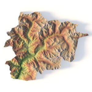
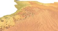
This Angola Topographic Map offers a detailed and scalable 3D model of the country’s diverse terrain. Created using high-resolution digital elevation data, the STL file is optimized for 3D printing (FDM and SLA) and CNC carving. It’s a perfect choice for terrain modeling, geospatial visualization, and creative educational applications.
This model allows for a tactile and visual representation of Angola’s geographic features including mountains, valleys, and plains.
Applications of the Angola Topographic STL Model
3D Printing: Create physical models of Angola’s terrain using FDM or SLA 3D printers, showcasing the country’s elevation data and unique landscapes, from the Central Plateau to the coastal plains.
CNC Machining: Perfect for crafting detailed relief maps from wood or metal, this model offers precise topographic details for professional design, geographic analysis, and artistic projects.
Laser Engraving: Use this model for high-precision laser engraving on metals or acrylics, capturing Angola’s intricate topography, including rivers, mountains, and desert regions.
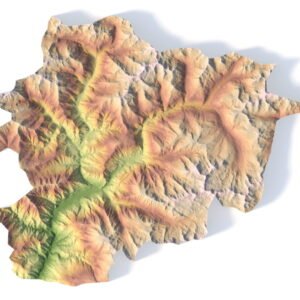
Detailed Terrain Representation for Educational and Professional Use
This Angola topographic map provides a comprehensive digital elevation model (DEM), offering accurate elevation data for researchers, educators, and designers. From the Huíla Plateau to the Kalahari Desert and the Congo Basin, this model accurately reflects Angola’s diverse geographical features, making it an essential resource for landform analysis, urban planning, and environmental studies.


Why Choose Our Angola Topographic Map STL Model?
✅ High-Precision Topography: The model delivers detailed terrain representation and elevation data for a wide range of applications, from academic research to engineering projects.
✅ Multi-Purpose: Ideal for 3D printing, CNC machining, and laser engraving, this model is versatile for professionals, educators, and hobbyists.
✅ Customizable: Modify the STL model to fit your project’s needs—whether for physical terrain models, geographic studies, or creative art installations.
Example Use Cases
Printing educational geography aids
CNC carving wooden topographic art
Building physical terrain mockups
Producing elevation-based architectural concepts
Crafting gifts or displays themed on Angola
FAQ
The description includes scaling factors for each axis. For example, if you see X – 0.001, Y – 0.001, Z – 0.003, this means the height is three times greater than the width and length. We scale height this way to emphasize the relief.
If you need uniform proportions, let us know—we’ll prepare a custom model upon request.
Send us your required specifications, and we’ll adapt the model accordingly.
Yes, we check every model for integrity and errors.
Yes. For better surface quality, we recommend printing it vertically.
Larger models require more polygons to preserve relief detail. Provide your desired dimensions, and we’ll prepare:
A single optimized model or
A segmented version with high resolution.
Yes, but polygon reduction may be necessary. Submit a request with your project’s dimensions for a tailored solution.