info@shustrik-maps.com

Contact me


    Free conversion to OBJ/FBX/STL/C4D
    • Services
    • About
    • FAQ
    • Site Map
    • How to buy?
    info@shustrik-maps.com

    Contact me


      Logo shustrik maps
      • 3D MODELSOBJ/FBX/C4D
        • Solar System

          3D MODELS OF SOLAR SYSTEM OBJECTS

          Planets (11)

          11 products

          Satellites (1)

          1 product

          Space objects (3)

          3 products
        • World

          World (8)

          8 products

          North Pole (1)

          1 product

          South Pole (1)

          1 product

          Fantasy (2)

          2 products
        • Continents

          North America (2)

          2 products

          South America (2)

          2 products

          Europe (2)

          2 products

          Asia (1)

          1 product

          Africa (2)

          2 products

          Oceania (3)

          3 products

          Antarctica (1)

          1 product
        • Peninsulas

          Peninsulas (1)

          1 product
        • Islands

          Islands (13)

          13 products
        • Countries

          All countries →

          3D MODELS OF THE COUNTRIES

          A | B | C | D | E | 

          F | G | H | I | J | 

          K | L | M | N | O | 

          P | Q | R | S | T | 

          U | V | W | Y | Z | 

          3D MODELS OF COUNTRIES BY CONTINENT

          NORTH AMERICA

          • Northern America
          • Central America
          • Caribbean

          SOUTH AMERICA

          EUROPE

          • Western Europe
          • Northern Europe
          • Southern Europe
          • Eastern Europe

          AFRICA

          • Eastern Africa
          • Middle Africa
          • Northern Africa
          • Southern Africa
          • Western Africa

          ASIA

          • Central Asia
          • Eastern Asia
          • Southeast Asia
          • Southern Asia
          • Western Asia
        • States of America

          All states →

          UNITED STATES 3D MODELS

          Alabama

          • C4D/OBJ/BLEND 
          • STL
          • Satellite Map

          Alaska

          • STL


          Arizona

          • C4D/OBJ/BLEND 
          • STL
          • Satellite Map

          Arkansas

          • C4D/OBJ/BLEND 
          • STL
          • Satellite Map

          California

          • Tex 1: C4D/OBJ
          • Tex 2: C4D/OBJ
          • STL
          • Satellite Map

          Colorado

          • C4D/OBJ/BLEND
          • STL
          • Satellite Map

          Connecticut

          • STL
          • Satellite Map

          Delaware

          • STL
          • Satellite Map

          Florida

          • C4D/OBJ/BLEND
          • STL
          • Satellite Map

          Georgia

          • STL
          • Satellite Map

          Hawaii

          • C4D/OBJ/BLEND
          • STL


          Idaho

          • C4D/OBJ/BLEND
          • STL
          • Satellite Map

          Illinois

          • STL
          • Satellite Map

          Indiana

          • C4D/OBJ/BLEND
          • STL
          • Satellite Map

          Iowa

          • C4D/OBJ/BLEND
          • STL
          • Satellite Map

          Kansas

          • C4D/OBJ/BLEND
          • STL
          • Satellite Map

          Kentucky

          • STL
          • Satellite Map

          Louisiana

          • STL
          • Satellite Map

          Maine

          • STL
          • Satellite Map

          Maryland

          • STL
          • Satellite Map

          Massachusetts

          • STL
          • Satellite Map

          Michigan

          • STL

          Minnesota

          • STL


          Mississippi

          • STL

          Missouri

          • STL

          Montana

          • Tex 1: C4D/OBJ
          • Tex 1: C4D/OBJ
          • STL

          Nebraska

          • C4D/OBJ/BLEND
          • STL


          Nevada

          • C4D/OBJ/BLEND
          • STL


          New Hampshire

          • STL


          New Jersey

          • STL

          New Mexico

          • C4D/OBJ/BLEND
          • STL

          New York

          • STL


          North Carolina

          • STL

          North Dakota

          • C4D/OBJ/BLEND
          • STL

          Ohio

          • STL


          Oklahoma

          • STL

          Oregon

          • C4D/OBJ/BLEND
          • STL

          Pennsylvania

          • STL


          Rhode Island

          • STL

          South Carolina

          • STL

          South Dakota

          • C4D/OBJ/BLEND
          • STL

          Tennessee

          • STL


          Texas

          • C4D/OBJ/BLEND
          • STL

          Utah

          • C4D/OBJ/BLEND
          • STL


          Vermont

          • STL


          Virginia

          • STL

          Washington

          • C4D/OBJ/BLEND
          • STL

          West Virginia

          • STL


          Wisconsin

          • STL

          Wyoming

          • C4D/OBJ/BLEND
          • STL
        • Canadian Provinces

          CANADIAN PROVINCES 3D MODELS

          Alberta

          British Columbia

          Manitoba

          New Brunswick

          Newfoundland

          Nova Scotia

          Ontario

          Prince Edward

          Quebec

          Saskatchewan

          CANADIAN TERRITORIES 3D MODELS

          Northwest Territories

          Nunavut

          Yukon

        • Parks & Canyons

          3D MODELS OF NATIONAL PARKS AND CANYONS

          Canyons (2)

          2 products
        • Other

          ART (4)

          4 products
      • 3D PRINT/CNC MODELSSTL
        • Planets
        • Satellites
        • Continents
        • Countries
        • Islands
        • States of America
        • Fantasy
        • Other
      • MAPSTIF/PSD/SVG
        • Satellite Maps
        • Night Satellite Map
        • Heightmaps/Raster DEM
        • Relief Maps
        • 3D Maps
        • Historical Maps
        • Outline Maps
      • FREE
      • SERVICES
      • A-Z
      Search
      0 items / $0.00
      Menu
      3D Models and 3D Maps
      0 items / $0.00
      3D model of North Dakota’s topographic map showing detailed elevation and terrain features.
      Topographic terrain model of North Dakota for 3D printing and CNC, featuring detailed elevation features.
      3D topographic model of North Dakota designed for landform visualization and educational purposes.
      Accurate elevation data in the North Dakota topographic map STL model, suitable for CNC machining and 3D printing.
      State of North Dakota relief map
      State of North Dakota 3d relief cnc files
      State of North Dakota 3D Print model
      Click to enlarge
      3D model of North Dakota’s topographic map showing detailed elevation and terrain features.
      Topographic terrain model of North Dakota for 3D printing and CNC, featuring detailed elevation features.
      3D topographic model of North Dakota designed for landform visualization and educational purposes.
      Accurate elevation data in the North Dakota topographic map STL model, suitable for CNC machining and 3D printing.
      State of North Dakota relief map
      State of North Dakota 3d relief cnc files
      State of North Dakota 3D Print model
      Home 3D PRINT/CNC MODELS States of America North Dakota Topographic Map STL Model
      3D model of North Carolina’s topographic map showing detailed elevation and terrain features.
      North Carolina Topographic Map STL Model $21.00
      Back to products
      3D model of Ohio’s topographic map showing detailed elevation and terrain features.
      Ohio Topographic Map STL Model $21.00

      North Dakota Topographic Map STL Model

      $21.00

      • File size: 932 MB / 475 MB
      • Model size: 339.2 mm x 214.56 mm x 2.744 mm
      • Resolution: 0,06 mm
      • Projection: Mercator
      • Scaling factor: X — 1; Y — 1; Z — 3
      • Polygons: 19 545 662
      • Vertices: 9 780 557
      • Geometry: Polygonal Tris only
      • Base: Open / Closed

      We accept VISA, Mastercard, ApplePay, GooglePay and other payment methods

      — OR —

      You can also purchase this product using MasterCard/Visa on
      RenderHub →  and 3Dexport →.

      SKU: SH_6313 Categories: 3D PRINT/CNC MODELS, States of America Tags: Mercator, States, STL
      Share:
      • Description
      Description

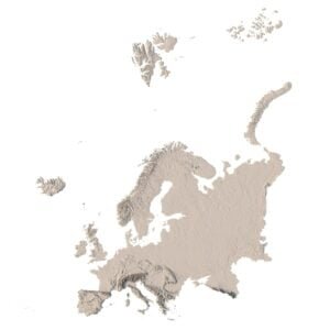
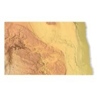
      Create Detailed North Dakota Terrain Models with This High-Resolution 3D STL

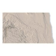
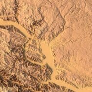
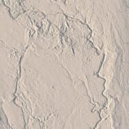
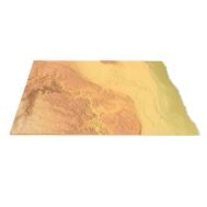
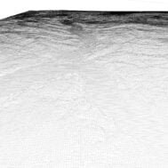
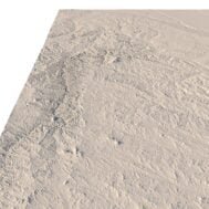
      The North Dakota Topographic Map STL model provides a high-resolution depiction of the state’s unique topography and geographic features. This 3D model is ideal for creating physical relief maps from wood, metal, plastic, or concrete. Whether used for landform visualization, educational projects, or professional GIS applications, this model delivers accurate elevation data for detailed terrain modeling. Perfect for 3D printing, CNC machining, and laser engraving.

      Features of the North Dakota Topographic STL Model

      • Accurate elevation data showcasing North Dakota’s plains, river valleys, and badlands.
      • Compatible with FDM/SLA 3D printers for high-quality terrain models.
      • Designed for CNC machining to create detailed relief maps from wood or metal.
      • Supports high-precision laser engraving for metal surface detailing.

      Applications of the North Dakota Topographic Map STL

      This STL model is ideal for creating raised relief maps and 3D representations of North Dakota’s landscape. Whether for landform visualization, educational uses, or professional GIS mapping projects, the accurate elevation data ensures precise terrain modeling for hobbyists and professionals alike.

      How to Use the North Dakota Terrain STL Model

      The North Dakota topographic map STL can be imported into CAD and GIS software for further customization. Its high-resolution elevation data and terrain accuracy make it ideal for 3D printing, CNC machining, or laser engraving, providing an accurate representation of North Dakota’s topography.

      Technical Specifications for the North Dakota Topographic STL Model

      • File Format: STL
      • Includes high-resolution elevation data for detailed terrain modeling.
      • Optimized for both low and high-resolution 3D printing.
      Wooden 3D map
      Terrain 3D print
      3D map of wood
      3D natural wood map
      3D metal map

        Related products

        3D STL model of Africa’s topography, showing elevation contours and landform details for terrain visualization and 3D printing.
        High-precision topographic map of Africa designed for CNC machining, ideal for creating relief models in wood or metal.

        Africa Topo Map STL Model

        $21.00
        Add to cart

        Albania Topographic Map – 3D Model for 3D Printing & CNC Carving

        $15.00
        Add to cart
        Full topographic STL model of Armenia with elevation features
        Detailed 3D terrain of Armenia with contour line structure

        Armenia Topographic Map – 3D Terrain Model for Printing & CNC Carving

        $15.00
        Add to cart
        Printable 3D terrain model of Australia with elevation detail
        CNC-compatible STL map of Australia’s landforms

        Australia Topographic Map – 3D Model for 3D Printing & CNC Carving

        $15.00
        Add to cart
        Full 3D STL model of Azerbaijan showing terrain detail
        Azerbaijan elevation STL with detailed contour lines

        Azerbaijan Topographic Map – 3D Model for 3D Printing & CNC Carving

        $15.00
        Add to cart
        3D terrain model of Bangladesh in STL format, front view
        Close-up of Bangladesh’s river deltas in STL model

        Bangladesh Topographic Map – 3D Model for 3D Printing & CNC Carving

        $15.00
        Add to cart
        -30%
        Corsica terrain 3D model
        Corsica 3D model

        Corsica Island STL model

        $20.00 Original price was: $20.00.$14.00Current price is: $14.00.
        Add to cart
        -19%
        Dominica STL model
        Dominica 3D model

        Dominica STL model

        $21.00 Original price was: $21.00.$17.00Current price is: $17.00.
        Add to cart
        Europe STL model
        Europe 3D model

        Europe STL model

        $21.00
        Add to cart
        -19%
        Kuwait STL model
        Kuwait 3D model

        Kuwait STL model

        $21.00 Original price was: $21.00.$17.00Current price is: $17.00.
        Add to cart
          INFO
          • About
          • Explore Our Terrain Services
          • Support
          • Shipping and delivery policy
          • Refund and Returns Policy
          • Privacy Policy
          • in**@***********ps.com
          • Blog
          How to buy
          • TERRAIN 3D MODELS FREE
          • Purchase with Crypto/PayPal/VISA
          • Buy on Cults3D.com
          • Buy on CGtrader.com
          • Buy on RenderHub.com
          • Buy on 3DExport.com
          • Discounts
          Buy 3D models
          • Planets
          • World
          • Continents
          • Peninsulas
          • Islands
          • Countries
          • States of America
          • Canadian Provinces
          • Canyons
          • Cities
          • Fantasy
          • Minecraft
          Buy 3D models for CNC
          • Planets
          • Continents
          • Islands
          • Countries
          • States of America

          DEM DSM DTM FBX OBJ STL

          SHUSTRIK-MAPS 2025
          • 3D MODELS
          • 3D PRINT/CNC MODELS
          • MAPS
          • FREE
          • About
          • FAQ
          • How to buy?
          • Site Map HTML
          • Explore Our Terrain Services
          Shopping cart
          Close
          Start typing to see products you are looking for.
          Your amount to pay has been updated
          The previous conversion quote has expired. Here is your new quote:
          Total
          $
          You Pay
          Back to checkout
          Place Order