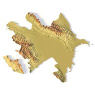
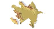


Azerbaijan Topographic Map – 3D Model for 3D Printing & CNC Carving
$15.00
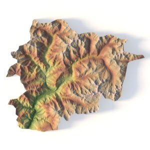
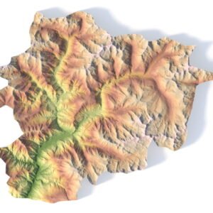
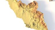
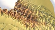
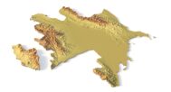
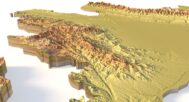
Detailed Terrain STL Model of Azerbaijan’s Diverse Landscapes
![]()
- File size: 455 MB
- Model size: 650 mm x 509 mm x 17 mm
- Projection: Mercator
- Scaling factor: X — 0,001; Y — 0,001; Z — 0,003
- Polygons: 9 545 678
- Vertices: 4 772 873
- Geometry: Polygonal Tris only
- Base: Closed
Explore Azerbaijan’s breathtaking geography with our high-resolution Azerbaijan Topographic Map STL Model. This meticulously crafted 3D model captures the country’s dramatic contrasts—from the soaring peaks of the Greater Caucasus to the vast lowlands of the Kura River Basin and the Caspian Sea coastline. Ideal for relief maps, educational projects, and creative design work, this model provides accurate elevation data and precise landform analysis of Azerbaijan’s unique terrain.
Applications of the Azerbaijan Topographic STL Model
3D Printing – Create physical terrain models using FDM or SLA 3D printers, showcasing Azerbaijan’s elevation variations and geographic diversity.
CNC Machining – Perfect for carving detailed relief maps from wood, metal, or acrylic, this model ensures professional-grade precision for design and geographic studies.
Laser Engraving – Ideal for high-precision engravings on metals or wood, capturing Azerbaijan’s intricate topography in stunning detail.
Detailed Terrain Representation for Education & Professional Use
This Azerbaijan topographic map features a comprehensive digital elevation model (DEM), providing researchers, educators, and designers with accurate elevation data. From the rugged mountains of Shahdag and Bazardüzü to the Mugan Plain and the Absheron Peninsula, this model accurately reflects Azerbaijan’s geographical diversity, making it an essential tool for:
Landform analysis
Terrain visualization
Geographic education
Architectural & urban planning projects
Bring Azerbaijan’s Landscapes to Life
Download our Azerbaijan Topographic Map STL Model to create customizable, high-detail 3D representations of the country’s terrain. Perfect for geography enthusiasts, educators, and designers alike!


Why Choose This Azerbaijan STL Terrain Map?
✔ Precision landform representation – Accurate elevation mapping
✔ Scalable for any project – Printable & carveable in various sizes & materials
✔ Exceptional detail – Captures Azerbaijan’s mountains, valleys & coastal regions
✔ Ready-to-use – Optimized for creative, academic, and professional applications
✔ Designed for realism – Perfect for terrain modeling & geographic displays
Sample Use Cases
Print a classroom-ready 3D model of Azerbaijan’s Caucasus Mountains
CNC-carve the country’s terrain into wood or metal for art & decor
Design elevation-aware 3D maps for urban planning or tourism projects
Create Azerbaijan-themed 3D art or display pieces
Produce unique geographic souvenirs for travelers & history buffs
FAQ
The description includes scaling factors for each axis. For example, if you see X – 0.001, Y – 0.001, Z – 0.003, this means the height is three times greater than the width and length. We scale height this way to emphasize the relief.
If you need uniform proportions, let us know—we’ll prepare a custom model upon request.
Send us your required specifications, and we’ll adapt the model accordingly.
Yes, we check every model for integrity and errors.
Yes. For better surface quality, we recommend printing it vertically.
Larger models require more polygons to preserve relief detail. Provide your desired dimensions, and we’ll prepare:
A single optimized model or
A segmented version with high resolution.
Yes, but polygon reduction may be necessary. Submit a request with your project’s dimensions for a tailored solution.