info@shustrik-maps.com

Contact me


    Free conversion to OBJ/FBX/STL/C4D
    • Services
    • About
    • FAQ
    • Site Map
    • How to buy?
    info@shustrik-maps.com

    Contact me


      Logo shustrik maps
      • 3D MODELSOBJ/FBX/C4D
        • Solar System

          3D MODELS OF SOLAR SYSTEM OBJECTS

          Planets (11)

          11 products

          Satellites (1)

          1 product

          Space objects (3)

          3 products
        • World

          World (8)

          8 products

          North Pole (1)

          1 product

          South Pole (1)

          1 product

          Fantasy (2)

          2 products
        • Continents

          North America (2)

          2 products

          South America (2)

          2 products

          Europe (2)

          2 products

          Asia (1)

          1 product

          Africa (2)

          2 products

          Oceania (3)

          3 products

          Antarctica (1)

          1 product
        • Peninsulas

          Peninsulas (1)

          1 product
        • Islands

          Islands (13)

          13 products
        • Countries

          All countries →

          3D MODELS OF THE COUNTRIES

          A | B | C | D | E | 

          F | G | H | I | J | 

          K | L | M | N | O | 

          P | Q | R | S | T | 

          U | V | W | Y | Z | 

          3D MODELS OF COUNTRIES BY CONTINENT

          NORTH AMERICA

          • Northern America
          • Central America
          • Caribbean

          SOUTH AMERICA

          EUROPE

          • Western Europe
          • Northern Europe
          • Southern Europe
          • Eastern Europe

          AFRICA

          • Eastern Africa
          • Middle Africa
          • Northern Africa
          • Southern Africa
          • Western Africa

          ASIA

          • Central Asia
          • Eastern Asia
          • Southeast Asia
          • Southern Asia
          • Western Asia
        • States of America

          All states →

          UNITED STATES 3D MODELS

          Alabama

          • C4D/OBJ/BLEND 
          • STL
          • Satellite Map

          Alaska

          • STL


          Arizona

          • C4D/OBJ/BLEND 
          • STL
          • Satellite Map

          Arkansas

          • C4D/OBJ/BLEND 
          • STL
          • Satellite Map

          California

          • Tex 1: C4D/OBJ
          • Tex 2: C4D/OBJ
          • STL
          • Satellite Map

          Colorado

          • C4D/OBJ/BLEND
          • STL
          • Satellite Map

          Connecticut

          • STL
          • Satellite Map

          Delaware

          • STL
          • Satellite Map

          Florida

          • C4D/OBJ/BLEND
          • STL
          • Satellite Map

          Georgia

          • STL
          • Satellite Map

          Hawaii

          • C4D/OBJ/BLEND
          • STL


          Idaho

          • C4D/OBJ/BLEND
          • STL
          • Satellite Map

          Illinois

          • STL
          • Satellite Map

          Indiana

          • C4D/OBJ/BLEND
          • STL
          • Satellite Map

          Iowa

          • C4D/OBJ/BLEND
          • STL
          • Satellite Map

          Kansas

          • C4D/OBJ/BLEND
          • STL
          • Satellite Map

          Kentucky

          • STL
          • Satellite Map

          Louisiana

          • STL
          • Satellite Map

          Maine

          • STL
          • Satellite Map

          Maryland

          • STL
          • Satellite Map

          Massachusetts

          • STL
          • Satellite Map

          Michigan

          • STL

          Minnesota

          • STL


          Mississippi

          • STL

          Missouri

          • STL

          Montana

          • Tex 1: C4D/OBJ
          • Tex 1: C4D/OBJ
          • STL

          Nebraska

          • C4D/OBJ/BLEND
          • STL


          Nevada

          • C4D/OBJ/BLEND
          • STL


          New Hampshire

          • STL


          New Jersey

          • STL

          New Mexico

          • C4D/OBJ/BLEND
          • STL

          New York

          • STL


          North Carolina

          • STL

          North Dakota

          • C4D/OBJ/BLEND
          • STL

          Ohio

          • STL


          Oklahoma

          • STL

          Oregon

          • C4D/OBJ/BLEND
          • STL

          Pennsylvania

          • STL


          Rhode Island

          • STL

          South Carolina

          • STL

          South Dakota

          • C4D/OBJ/BLEND
          • STL

          Tennessee

          • STL


          Texas

          • C4D/OBJ/BLEND
          • STL

          Utah

          • C4D/OBJ/BLEND
          • STL


          Vermont

          • STL


          Virginia

          • STL

          Washington

          • C4D/OBJ/BLEND
          • STL

          West Virginia

          • STL


          Wisconsin

          • STL

          Wyoming

          • C4D/OBJ/BLEND
          • STL
        • Canadian Provinces

          CANADIAN PROVINCES 3D MODELS

          Alberta

          British Columbia

          Manitoba

          New Brunswick

          Newfoundland

          Nova Scotia

          Ontario

          Prince Edward

          Quebec

          Saskatchewan

          CANADIAN TERRITORIES 3D MODELS

          Northwest Territories

          Nunavut

          Yukon

        • Parks & Canyons

          3D MODELS OF NATIONAL PARKS AND CANYONS

          Canyons (2)

          2 products
        • Other

          ART (4)

          4 products
      • 3D PRINT/CNC MODELSSTL
        • Planets
        • Satellites
        • Continents
        • Countries
        • Islands
        • States of America
        • Fantasy
        • Other
      • MAPSTIF/PSD/SVG
        • Satellite Maps
        • Night Satellite Map
        • Heightmaps/Raster DEM
        • Relief Maps
        • 3D Maps
        • Historical Maps
        • Outline Maps
      • FREE
      • SERVICES
      • A-Z
      Search
      0 items / $0.00
      Menu
      3D Models and 3D Maps
      0 items / $0.00
      3D model of Hawaii’s topographic map showing island elevation
      Topographic terrain model of Hawaii designed for 3D printing and CNC machining, showing island features.
      Topographic model of Hawaii’s Big Island showcasing elevation data for landscape visualization.
      Accurate island elevation data in the Hawaii topographic map STL model, suitable for 3D printing and CNC machining.
      State of Hawaii relief map
      State of Hawaii 3D Print model
      State of Hawaii 3d relief cnc files
      Click to enlarge
      3D model of Hawaii’s topographic map showing island elevation
      Topographic terrain model of Hawaii designed for 3D printing and CNC machining, showing island features.
      Topographic model of Hawaii’s Big Island showcasing elevation data for landscape visualization.
      Accurate island elevation data in the Hawaii topographic map STL model, suitable for 3D printing and CNC machining.
      State of Hawaii relief map
      State of Hawaii 3D Print model
      State of Hawaii 3d relief cnc files
      Home 3D PRINT/CNC MODELS States of America Hawaii Topographic Map STL Model
      3D model of Georgia’s topographic map showing elevation data
      Topographic Map of Georgia USA STL Model $21.00
      Back to products
      3D model of Illinois’ topographic map showing detailed elevation and terrain features.
      Illinois Topographic Map STL Model $21.00

      Hawaii Topographic Map STL Model

      $21.00

      • Files size: 451 MB / 400 MB
      • Model size: 242.231 mm х 157.076 mm х 5.171 mm
      • Resolution: 0,026 mm
      • Projection: Mercator
      • Scaling factor: X — 1; Y — 1; Z — 3
      • Polygons: 9 470 750
      • Vertices: 4 753 696
      • Geometry: Polygonal Tris only
      • Base: Open / Closed

      We accept VISA, Mastercard, ApplePay, GooglePay and other payment methods

      — OR —

      You can also purchase this product using MasterCard/Visa on
      RenderHub →  and 3Dexport →.

      SKU: SH_4315 Categories: 3D PRINT/CNC MODELS, States of America Tags: H, Mercator, States, STL
      Share:
      • Description
      Description

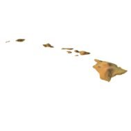
      Create Detailed Hawaii Terrain Models with This 3D STL File

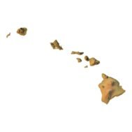
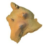
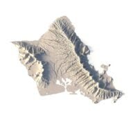
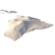
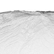
      The Hawaii Topographic Map STL model captures the unique island elevation and topographic features of the Hawaiian Islands. This 3D model is ideal for creating relief models from wood, metal, plastic, or concrete. Designed for professionals and hobbyists alike, this model is perfect for landform visualization, educational projects, or geographic studies. Whether for the Big Island or other regions, this file provides detailed geospatial data for accurate terrain representation.

      Features of the Hawaii Topographic STL Model

      • Compatible with FDM/SLA 3D printers for terrain model creation.
      • Supports CNC machining for wood and metal topographic models.
      • High-precision laser engraving for metal surfaces.

      Applications of the Hawaii Topographic Map STL

      This STL model is ideal for creating raised relief maps and 3D representations of Hawaii’s islands. It’s useful for landform visualization and educational projects focused on Hawaii’s diverse geography. Perfect for designers, educators, or geographers, the model provides detailed digital elevation data for accurate 3D mapping.

      How to Use the Hawaii Terrain STL Model

      The Hawaii topographic map STL can be imported into popular mapping software and CAD tools for further customization. With accurate island elevation data and detailed contours, it is an excellent choice for projects involving 3D printing, CNC routing, or laser engraving, ensuring a faithful representation of Hawaii’s landscape.

      Wooden 3D map
      Terrain 3D print
      3D map of wood
      3D natural wood map
      3D metal map
        Hawaii Terrain 3D model
        Hawaii 3D terrain without water

        Related products

        Albania Topographic Map – 3D Model for 3D Printing & CNC Carving

        $15.00
        Add to cart
        High-detail 3D terrain of Andorra with elevation data
        3D front view of Andorra terrain STL model

        Andorra Topographic Map – 3D Terrain Model for Printing & CNC Carving

        $15.00
        Add to cart
        3D terrain model of Belgium in STL format, front view
        STL file of Belgium map for CNC and 3D printing

        Belgium Topographic Map – 3D Model for 3D Printing & CNC Carving

        $15.00
        Add to cart
        Europe STL model
        Europe 3D model

        Europe STL model

        $21.00
        Add to cart
        -19%
        France 3D Print model
        France 3D model

        France STL model

        $21.00 Original price was: $21.00.$17.00Current price is: $17.00.
        Add to cart
        3D model of Idaho’s topographic map showing detailed elevation and terrain features.
        Topographic terrain model of Idaho designed for 3D printing and CNC with detailed elevation features.

        Idaho Topographic Map STL Model

        $21.00
        Add to cart
        -19%
        Jamaica STL model
        Jamaica 3D model

        Jamaica STL model

        $21.00 Original price was: $21.00.$17.00Current price is: $17.00.
        Add to cart
        -19%
        Kosovo STL model
        Kosovo 3D model

        Kosovo STL model

        $21.00 Original price was: $21.00.$17.00Current price is: $17.00.
        Add to cart
        North America STL model
        North America 3D model

        North America STL model

        $21.00
        Add to cart
        South America STL model
        South America 3D model

        South America STL model

        $21.00
        Add to cart
          INFO
          • About
          • Explore Our Terrain Services
          • Support
          • Shipping and delivery policy
          • Refund and Returns Policy
          • Privacy Policy
          • in**@***********ps.com
          • Blog
          How to buy
          • TERRAIN 3D MODELS FREE
          • Purchase with Crypto/PayPal/VISA
          • Buy on Cults3D.com
          • Buy on CGtrader.com
          • Buy on RenderHub.com
          • Buy on 3DExport.com
          • Discounts
          Buy 3D models
          • Planets
          • World
          • Continents
          • Peninsulas
          • Islands
          • Countries
          • States of America
          • Canadian Provinces
          • Canyons
          • Cities
          • Fantasy
          • Minecraft
          Buy 3D models for CNC
          • Planets
          • Continents
          • Islands
          • Countries
          • States of America

          DEM DSM DTM FBX OBJ STL

          SHUSTRIK-MAPS 2025
          • 3D MODELS
            • Solar System
            • World
            • Continents
            • Peninsulas
            • Islands
            • Countries
            • States of America
            • Canadian Provinces
            • Canyons
            • Buildings
            • Fantasy
            • ART
          • 3D PRINT/CNC MODELS
            • Planets
            • Satellites
            • Continents
            • Countries
            • Islands
            • States of America
            • Fantasy
            • Other
          • MAPS
          • A-Z
          • FREE
          • About
          • FAQ
          • How to buy?
          • Site Map HTML
          • Explore Our Terrain Services
          Shopping cart
          Close
          Start typing to see products you are looking for.
          Your amount to pay has been updated
          The previous conversion quote has expired. Here is your new quote:
          Total
          $
          You Pay
          Back to checkout
          Place Order