info@shustrik-maps.com

Contact me


    Free conversion to OBJ/FBX/STL/C4D
    • Services
    • About
    • FAQ
    • Site Map
    • How to buy?
    info@shustrik-maps.com

    Contact me


      Logo shustrik maps
      • 3D MODELSOBJ/FBX/C4D
        • Solar System

          3D MODELS OF SOLAR SYSTEM OBJECTS

          Planets (11)

          11 products

          Satellites (1)

          1 product

          Space objects (3)

          3 products
        • World

          World (8)

          8 products

          North Pole (1)

          1 product

          South Pole (1)

          1 product

          Fantasy (2)

          2 products
        • Continents

          North America (2)

          2 products

          South America (2)

          2 products

          Europe (2)

          2 products

          Asia (1)

          1 product

          Africa (2)

          2 products

          Oceania (3)

          3 products

          Antarctica (1)

          1 product
        • Peninsulas

          Peninsulas (1)

          1 product
        • Islands

          Islands (13)

          13 products
        • Countries

          All countries →

          3D MODELS OF THE COUNTRIES

          A | B | C | D | E | 

          F | G | H | I | J | 

          K | L | M | N | O | 

          P | Q | R | S | T | 

          U | V | W | Y | Z | 

          3D MODELS OF COUNTRIES BY CONTINENT

          NORTH AMERICA

          • Northern America
          • Central America
          • Caribbean

          SOUTH AMERICA

          EUROPE

          • Western Europe
          • Northern Europe
          • Southern Europe
          • Eastern Europe

          AFRICA

          • Eastern Africa
          • Middle Africa
          • Northern Africa
          • Southern Africa
          • Western Africa

          ASIA

          • Central Asia
          • Eastern Asia
          • Southeast Asia
          • Southern Asia
          • Western Asia
        • States of America

          All states →

          UNITED STATES 3D MODELS

          Alabama

          • C4D/OBJ/BLEND 
          • STL
          • Satellite Map

          Alaska

          • STL


          Arizona

          • C4D/OBJ/BLEND 
          • STL
          • Satellite Map

          Arkansas

          • C4D/OBJ/BLEND 
          • STL
          • Satellite Map

          California

          • Tex 1: C4D/OBJ
          • Tex 2: C4D/OBJ
          • STL
          • Satellite Map

          Colorado

          • C4D/OBJ/BLEND
          • STL
          • Satellite Map

          Connecticut

          • STL
          • Satellite Map

          Delaware

          • STL
          • Satellite Map

          Florida

          • C4D/OBJ/BLEND
          • STL
          • Satellite Map

          Georgia

          • STL
          • Satellite Map

          Hawaii

          • C4D/OBJ/BLEND
          • STL


          Idaho

          • C4D/OBJ/BLEND
          • STL
          • Satellite Map

          Illinois

          • STL
          • Satellite Map

          Indiana

          • C4D/OBJ/BLEND
          • STL
          • Satellite Map

          Iowa

          • C4D/OBJ/BLEND
          • STL
          • Satellite Map

          Kansas

          • C4D/OBJ/BLEND
          • STL
          • Satellite Map

          Kentucky

          • STL
          • Satellite Map

          Louisiana

          • STL
          • Satellite Map

          Maine

          • STL
          • Satellite Map

          Maryland

          • STL
          • Satellite Map

          Massachusetts

          • STL
          • Satellite Map

          Michigan

          • STL

          Minnesota

          • STL


          Mississippi

          • STL

          Missouri

          • STL

          Montana

          • Tex 1: C4D/OBJ
          • Tex 1: C4D/OBJ
          • STL

          Nebraska

          • C4D/OBJ/BLEND
          • STL


          Nevada

          • C4D/OBJ/BLEND
          • STL


          New Hampshire

          • STL


          New Jersey

          • STL

          New Mexico

          • C4D/OBJ/BLEND
          • STL

          New York

          • STL


          North Carolina

          • STL

          North Dakota

          • C4D/OBJ/BLEND
          • STL

          Ohio

          • STL


          Oklahoma

          • STL

          Oregon

          • C4D/OBJ/BLEND
          • STL

          Pennsylvania

          • STL


          Rhode Island

          • STL

          South Carolina

          • STL

          South Dakota

          • C4D/OBJ/BLEND
          • STL

          Tennessee

          • STL


          Texas

          • C4D/OBJ/BLEND
          • STL

          Utah

          • C4D/OBJ/BLEND
          • STL


          Vermont

          • STL


          Virginia

          • STL

          Washington

          • C4D/OBJ/BLEND
          • STL

          West Virginia

          • STL


          Wisconsin

          • STL

          Wyoming

          • C4D/OBJ/BLEND
          • STL
        • Canadian Provinces

          CANADIAN PROVINCES 3D MODELS

          Alberta

          British Columbia

          Manitoba

          New Brunswick

          Newfoundland

          Nova Scotia

          Ontario

          Prince Edward

          Quebec

          Saskatchewan

          CANADIAN TERRITORIES 3D MODELS

          Northwest Territories

          Nunavut

          Yukon

        • Parks & Canyons

          3D MODELS OF NATIONAL PARKS AND CANYONS

          Canyons (2)

          2 products
        • Other

          ART (6)

          6 products
      • 3D PRINT/CNC MODELSSTL
        • Planets
        • Satellites
        • Continents
        • Countries
        • Islands
        • States of America
        • Fantasy
        • Other
      • MAPSTIF/PSD/SVG
        • Satellite Maps
        • Night Satellite Map
        • Heightmaps/Raster DEM
        • Relief Maps
        • 3D Maps
        • Historical Maps
        • Outline Maps
      • FREE
      • SERVICES
      • A-Z
      Search
      0 items / $0.00
      Menu
      3D Models and 3D Maps
      0 items / $0.00
      -30%
      A high-resolution top-down view of the Florida State 3D Terrain Map, showcasing the detailed coastal lines and varied terrain.
      A digital render of the Florida State Terrain Map available for download in OBJ format, highlighting the realistic elevation and land features.
      Close-up of Florida’s coastline on the 3D terrain map, displaying the intricate details of the coastal regions.
      Perspective view of the Florida State 3D Terrain Map, showing the varying elevations across the state.
      A preview of the downloadable digital 3D model of Florida's terrain in OBJ format, ready for 3D software use.
      A high-resolution image of the Florida terrain map, available for download as an OBJ file for various digital and print uses.
      A detailed 3D map showing the topographical features of Florida State, perfect for educational and professional projects.
      A downloadable digital terrain model of Florida State in 3D, ideal for use in 3D printing, virtual design, and education.
      Florida State Terrain Map 3D Model Mesh
      Click to enlarge
      A high-resolution top-down view of the Florida State 3D Terrain Map, showcasing the detailed coastal lines and varied terrain.
      A digital render of the Florida State Terrain Map available for download in OBJ format, highlighting the realistic elevation and land features.
      Close-up of Florida’s coastline on the 3D terrain map, displaying the intricate details of the coastal regions.
      Perspective view of the Florida State 3D Terrain Map, showing the varying elevations across the state.
      A preview of the downloadable digital 3D model of Florida's terrain in OBJ format, ready for 3D software use.
      A high-resolution image of the Florida terrain map, available for download as an OBJ file for various digital and print uses.
      A detailed 3D map showing the topographical features of Florida State, perfect for educational and professional projects.
      A downloadable digital terrain model of Florida State in 3D, ideal for use in 3D printing, virtual design, and education.
      Florida State Terrain Map 3D Model Mesh
      Home 3D MODELS States of America Florida State Terrain Map 3D Model
      High-resolution Syria satellite map displaying detailed topography.
      Syria Satellite Map $15.00
      Back to products
      High-resolution map of Rocky Mountain National Park displaying detailed topography and trails.
      Rocky Mountain National Park Map $15.00

      Florida State Terrain Map 3D Model

      $40.00 Original price was: $40.00.$28.00Current price is: $28.00.

      3D Model

      • Format: OBJ
      • File size (unzipped): 1.12 GB
      • Polygons: 9 988 536
      • Vertices: 4 998 740
      • Geometry: Polygonal Tris only
      • Model size: 2543.75 mm x 2418.75 mm x 5.5059 mm
      • Projection: Mercator
      • Base: Open

      Textures

      • Normal Map TIF 8192*7789*48b – Use this map to reveal fine details of the relief.
      • Satellite Maps TIF 18991*18053*24b.

      We accept VISA, Mastercard, ApplePay, GooglePay and other payment methods

      — OR —

      You can also purchase this product using MasterCard/Visa on
      RenderHub →  and 3Dexport →.

      SKU: SH_7729 Category: States of America Tags: Mercator, OBJ, States
      Share:
      • Description
      Description

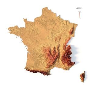
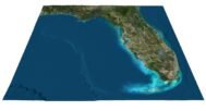
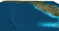
      Discover the beauty of Florida’s landscape with this downloadable 3D Terrain Map. Available in a high-resolution OBJ format, this digital model captures the intricate details of Florida’s diverse terrain, from its coastal edges to elevated regions.

      Features:

      • Downloadable Format: Provided as a high-quality OBJ file, easily importable into various 3D software for further use or modification.
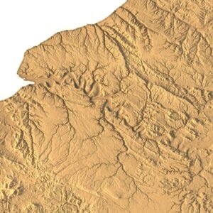
      • High-Resolution Detailing: The model features exceptional detail, making it suitable for educational projects, 3D printing, and virtual environments.
      • Realistic Topography: Accurately represents Florida’s geographical features with true-to-life elevations and contours.
      • Versatile Use: Ideal for use in educational presentations, architectural projects, game design, or as a basis for customized models.
      • Instant Access: Download the model immediately after purchase, no waiting required.

      Why You Should Buy: This Florida State Terrain Map 3D Model is a perfect digital asset for anyone interested in the geography of Florida. Whether you are a student, educator, designer, or hobbyist, this model offers endless possibilities for creativity and learning. With instant access to a highly detailed OBJ file, you can easily integrate this model into your projects or 3D printing plans.

      Florida C4D

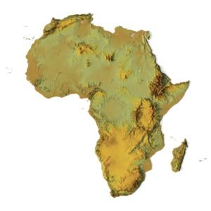
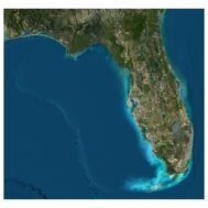
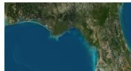
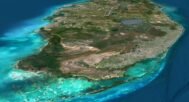
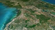
      Florida Satellite image

      Florida Satellite Map

      The satellite texture is high resolution in TIF format.
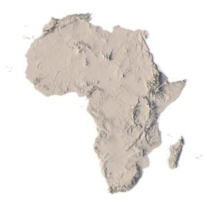
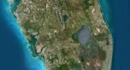
      Florida Normal Map

      Florida Normal Map

      Use this map to reveal fine details of the relief.

      Have a Question?

      Do you need an extra high resolution 3D terrain of Florida?
      Do you need Shapefile?
      Do you need more resolution satellite images?
      Do you need a 3D model in BLEND, C4D or FBX format?
      WRITE A MESSAGE
      State of Florida STL model
      Florida Satellite Map

      Related products

      3D STL model of Africa’s topography, showing elevation contours and landform details for terrain visualization and 3D printing.
      High-precision topographic map of Africa designed for CNC machining, ideal for creating relief models in wood or metal.

      Africa Topo Map STL Model

      $21.00
      Add to cart
      Full 3D STL model of Azerbaijan showing terrain detail
      Azerbaijan elevation STL with detailed contour lines

      Azerbaijan Topographic Map – 3D Model for 3D Printing & CNC Carving

      $15.00
      Add to cart
      3D terrain model of Bangladesh in STL format, front view
      Close-up of Bangladesh’s river deltas in STL model

      Bangladesh Topographic Map – 3D Model for 3D Printing & CNC Carving

      $15.00
      Add to cart
      -30%
      Corsica terrain 3D model
      Corsica 3D model

      Corsica Island STL model

      $20.00 Original price was: $20.00.$14.00Current price is: $14.00.
      Add to cart
      -19%
      France 3D Print model
      France 3D model

      France STL model

      $21.00 Original price was: $21.00.$17.00Current price is: $17.00.
      Add to cart
      3D model of Idaho’s topographic map showing detailed elevation and terrain features.
      Topographic terrain model of Idaho designed for 3D printing and CNC with detailed elevation features.

      Idaho Topographic Map STL Model

      $21.00
      Add to cart
      3D terrain model of Jamaica in STL format, front view

      Jamaica Topographic Map – 3D Model for 3D Printing & CNC Carving

      $15.00
      Add to cart
      3D terrain model of Japan in STL format, front view
      STL file of Japan map for CNC and 3D printing

      Japan Topographic Map – 3D Model for 3D Printing & CNC Carving

      $15.00
      Add to cart
      3D terrain model of Kazakhstan in STL format, front view
      STL file of Kazakhstan map for CNC and 3D printing

      Kazakhstan Topographic Map – 3D Model for 3D Printing & CNC Carving

      $15.00
      Add to cart
      France maps 3d
      3d relief map of France

      Relief map of France

      Read more
        INFO
        • About
        • Explore Our Terrain Services
        • Support
        • Shipping and delivery policy
        • Refund and Returns Policy
        • Privacy Policy
        • in**@***********ps.com
        • Blog
        How to buy
        • TERRAIN 3D MODELS FREE
        • Purchase with Crypto/PayPal/VISA
        • Buy on Cults3D.com
        • Buy on CGtrader.com
        • Buy on RenderHub.com
        • Buy on 3DExport.com
        • Discounts
        Buy 3D models
        • Planets
        • World
        • Continents
        • Peninsulas
        • Islands
        • Countries
        • States of America
        • Canadian Provinces
        • Canyons
        • Cities
        • Fantasy
        • Minecraft
        Buy 3D models for CNC
        • Planets
        • Continents
        • Islands
        • Countries
        • States of America

        DEM DSM DTM FBX OBJ STL

        SHUSTRIK-MAPS 2025
        • 3D MODELS
          • Solar System
          • World
          • Continents
          • Peninsulas
          • Islands
          • Countries
          • States of America
          • Canadian Provinces
          • Canyons
          • Buildings
          • Fantasy
          • ART
        • 3D PRINT/CNC MODELS
          • Planets
          • Satellites
          • Continents
          • Countries
          • Islands
          • States of America
          • Fantasy
          • Other
        • MAPS
        • A-Z
        • FREE
        • About
        • FAQ
        • How to buy?
        • Site Map HTML
        • Explore Our Terrain Services
        Shopping cart
        Close
        Start typing to see products you are looking for.
        Your amount to pay has been updated
        The previous conversion quote has expired. Here is your new quote:
        Total
        $
        You Pay
        Back to checkout
        Place Order