info@shustrik-maps.com

Contact me


    Free conversion to OBJ/FBX/STL/C4D
    • Services
    • About
    • FAQ
    • Site Map
    • How to buy?
    info@shustrik-maps.com

    Contact me


      Logo shustrik maps
      • 3D MODELSOBJ/FBX/C4D
        • Solar System

          3D MODELS OF SOLAR SYSTEM OBJECTS

          Planets (11)

          11 products

          Satellites (1)

          1 product

          Space objects (3)

          3 products
        • World

          World (8)

          8 products

          North Pole (1)

          1 product

          South Pole (1)

          1 product

          Fantasy (2)

          2 products
        • Continents

          North America (2)

          2 products

          South America (2)

          2 products

          Europe (2)

          2 products

          Asia (1)

          1 product

          Africa (2)

          2 products

          Oceania (3)

          3 products

          Antarctica (1)

          1 product
        • Peninsulas

          Peninsulas (1)

          1 product
        • Islands

          Islands (13)

          13 products
        • Countries

          All countries →

          3D MODELS OF THE COUNTRIES

          A | B | C | D | E | 

          F | G | H | I | J | 

          K | L | M | N | O | 

          P | Q | R | S | T | 

          U | V | W | Y | Z | 

          3D MODELS OF COUNTRIES BY CONTINENT

          NORTH AMERICA

          • Northern America
          • Central America
          • Caribbean

          SOUTH AMERICA

          EUROPE

          • Western Europe
          • Northern Europe
          • Southern Europe
          • Eastern Europe

          AFRICA

          • Eastern Africa
          • Middle Africa
          • Northern Africa
          • Southern Africa
          • Western Africa

          ASIA

          • Central Asia
          • Eastern Asia
          • Southeast Asia
          • Southern Asia
          • Western Asia
        • States of America

          All states →

          UNITED STATES 3D MODELS

          Alabama

          • C4D/OBJ/BLEND 
          • STL
          • Satellite Map

          Alaska

          • STL


          Arizona

          • C4D/OBJ/BLEND 
          • STL
          • Satellite Map

          Arkansas

          • C4D/OBJ/BLEND 
          • STL
          • Satellite Map

          California

          • Tex 1: C4D/OBJ
          • Tex 2: C4D/OBJ
          • STL
          • Satellite Map

          Colorado

          • C4D/OBJ/BLEND
          • STL
          • Satellite Map

          Connecticut

          • STL
          • Satellite Map

          Delaware

          • STL
          • Satellite Map

          Florida

          • C4D/OBJ/BLEND
          • STL
          • Satellite Map

          Georgia

          • STL
          • Satellite Map

          Hawaii

          • C4D/OBJ/BLEND
          • STL


          Idaho

          • C4D/OBJ/BLEND
          • STL
          • Satellite Map

          Illinois

          • STL
          • Satellite Map

          Indiana

          • C4D/OBJ/BLEND
          • STL
          • Satellite Map

          Iowa

          • C4D/OBJ/BLEND
          • STL
          • Satellite Map

          Kansas

          • C4D/OBJ/BLEND
          • STL
          • Satellite Map

          Kentucky

          • STL
          • Satellite Map

          Louisiana

          • STL
          • Satellite Map

          Maine

          • STL
          • Satellite Map

          Maryland

          • STL
          • Satellite Map

          Massachusetts

          • STL
          • Satellite Map

          Michigan

          • STL

          Minnesota

          • STL


          Mississippi

          • STL

          Missouri

          • STL

          Montana

          • Tex 1: C4D/OBJ
          • Tex 1: C4D/OBJ
          • STL

          Nebraska

          • C4D/OBJ/BLEND
          • STL


          Nevada

          • C4D/OBJ/BLEND
          • STL


          New Hampshire

          • STL


          New Jersey

          • STL

          New Mexico

          • C4D/OBJ/BLEND
          • STL

          New York

          • STL


          North Carolina

          • STL

          North Dakota

          • C4D/OBJ/BLEND
          • STL

          Ohio

          • STL


          Oklahoma

          • STL

          Oregon

          • C4D/OBJ/BLEND
          • STL

          Pennsylvania

          • STL


          Rhode Island

          • STL

          South Carolina

          • STL

          South Dakota

          • C4D/OBJ/BLEND
          • STL

          Tennessee

          • STL


          Texas

          • C4D/OBJ/BLEND
          • STL

          Utah

          • C4D/OBJ/BLEND
          • STL


          Vermont

          • STL


          Virginia

          • STL

          Washington

          • C4D/OBJ/BLEND
          • STL

          West Virginia

          • STL


          Wisconsin

          • STL

          Wyoming

          • C4D/OBJ/BLEND
          • STL
        • Canadian Provinces

          CANADIAN PROVINCES 3D MODELS

          Alberta

          British Columbia

          Manitoba

          New Brunswick

          Newfoundland

          Nova Scotia

          Ontario

          Prince Edward

          Quebec

          Saskatchewan

          CANADIAN TERRITORIES 3D MODELS

          Northwest Territories

          Nunavut

          Yukon

        • Parks & Canyons

          3D MODELS OF NATIONAL PARKS AND CANYONS

          Canyons (2)

          2 products
        • Other

          ART (4)

          4 products
      • 3D PRINT/CNC MODELSSTL
        • Planets
        • Satellites
        • Continents
        • Countries
        • Islands
        • States of America
        • Fantasy
        • Other
      • MAPSTIF/PSD/SVG
        • Satellite Maps
        • Night Satellite Map
        • Heightmaps/Raster DEM
        • Relief Maps
        • 3D Maps
        • Historical Maps
        • Outline Maps
      • FREE
      • SERVICES
      • A-Z
      Search
      1 item / $17.00
      Menu
      3D Models and 3D Maps
      1 item / $17.00
      “Jordan STL model” has been added to your cart. View cart
      3D model of Florida’s topographic map showing elevation data and detailed contours.
      Florida terrain model designed for CNC and 3D printing, showing elevation and contour lines.
      Topographic model of Florida designed for landscape visualization and terrain modeling.
      Detailed elevation data in the Florida topographic map STL model, suitable for CNC and 3D printing.
      State of Florida relief map
      State of Florida 3D Print model
      State of Florida 3d relief cnc files
      Click to enlarge
      3D model of Florida’s topographic map showing elevation data and detailed contours.
      Florida terrain model designed for CNC and 3D printing, showing elevation and contour lines.
      Topographic model of Florida designed for landscape visualization and terrain modeling.
      Detailed elevation data in the Florida topographic map STL model, suitable for CNC and 3D printing.
      State of Florida relief map
      State of Florida 3D Print model
      State of Florida 3d relief cnc files
      Home 3D PRINT/CNC MODELS States of America Florida Topographic Map STL Model
      3D model of Delaware’s topographic map showing detailed elevation data
      Topographic Map Delaware STL Model $21.00
      Back to products
      Ecuador 3D model
      Ecuador STL model $21.00 Original price was: $21.00.$17.00Current price is: $17.00.

      Florida Topographic Map STL Model

      $21.00

      • File size: 808 MB / 400MB
      • Model size: 338.4 mm x 324.42 mm x 0.246 mm
      • Resolution: 0,06 mm
      • Projection: Mercator
      • Scaling factor: X — 1; Y — 1; Z — 3
      • Polygons: 16 958 128
      • Vertices: 8 530 608
      • Geometry: Polygonal Tris only
      • Base: Open / Closed

      We accept VISA, Mastercard, ApplePay, GooglePay and other payment methods

      — OR —

      You can also purchase this product using MasterCard/Visa on
      RenderHub →  and 3Dexport →.

      SKU: SH_4421 Categories: 3D PRINT/CNC MODELS, States of America Tags: Mercator, States, STL
      Share:
      • Description
      Description

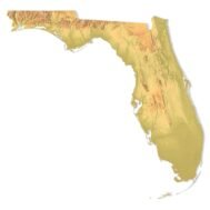
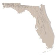
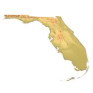
      Create Detailed Florida Terrain Models with This 3D STL File

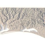
      The Florida Topographic Map STL model provides an accurate representation of the state’s topography and elevation. Ideal for crafting physical models from wood, metal, plastic, or concrete, this 3D model is perfect for creating raised relief maps and visualizing terrain features. It is designed for professionals and hobbyists looking to capture Florida’s unique geographical features using GIS data for precise landscape modeling.

      Features of the Florida Topographic STL Model

      • Compatible with FDM/SLA 3D printers for creating physical models.
      • Works with CNC machines for wood or metal terrain carving.
      • Supports laser engraving for high-precision topographic detail on metal surfaces.

      Uses for the Florida Topographic Map STL

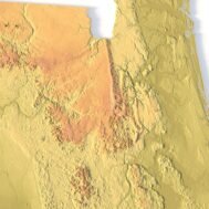
      This STL file is ideal for creating relief maps and terrain models, useful for educational purposes, geographic studies, or landscape visualization. The detailed elevation and contours of Florida’s terrain make this model an excellent tool for professionals working with GIS data or those interested in 3D modeling Florida’s unique geography.

      How to Use the Florida Terrain STL Model

      The Florida topographic map STL can be imported into various CAD and GIS software for further customization. With its precise elevation and terrain data, it is perfect for projects involving 3D printing, CNC machining, or laser engraving, offering accurate representations of Florida’s diverse landscape.

      Wooden 3D map
      Terrain 3D print
      3D map of wood
      3D natural wood map
      3D metal map
      Florida Satellite Map

      Related products

      Afghanistan terrain map 3D printed in white plastic, showing elevation details
      Wooden Afghanistan relief map carved on CNC machine, natural finish

      Afghanistan Topographic Map – 3D Model for 3D Printing & CNC Carving

      $15.00
      Add to cart

      Albania Topographic Map – 3D Model for 3D Printing & CNC Carving

      $15.00
      Add to cart
      Angola 3D STL terrain model with full topographic details
      Topographic contour lines of Angola in STL file

      Angola Topographic Map – 3D Terrain Model for Printing & CNC Carving

      $15.00
      Add to cart
      Asia STL model
      Asia 3D model

      Asia STL model

      $21.00
      Add to cart
      Printable 3D terrain model of Australia with elevation detail
      CNC-compatible STL map of Australia’s landforms

      Australia Topographic Map – 3D Model for 3D Printing & CNC Carving

      $15.00
      Add to cart
      3D terrain model of Bangladesh in STL format, front view
      Close-up of Bangladesh’s river deltas in STL model

      Bangladesh Topographic Map – 3D Model for 3D Printing & CNC Carving

      $15.00
      Add to cart
      -30%
      Corsica terrain 3D model
      Corsica 3D model

      Corsica Island STL model

      $20.00 Original price was: $20.00.$14.00Current price is: $14.00.
      Add to cart
      -30%
      Crete STL model
      Crete 3D model

      Crete Island STL model

      $20.00 Original price was: $20.00.$14.00Current price is: $14.00.
      Add to cart
      -19%
      France 3D Print model
      France 3D model

      France STL model

      $21.00 Original price was: $21.00.$17.00Current price is: $17.00.
      Add to cart
      3D model of Georgia’s topographic map showing elevation data
      Topographic terrain model of Georgia for 3D printing and CNC machining, with detailed contours.

      Topographic Map of Georgia USA STL Model

      $21.00
      Add to cart
      INFO
      • About
      • Explore Our Terrain Services
      • Support
      • Shipping and delivery policy
      • Refund and Returns Policy
      • Privacy Policy
      • in**@***********ps.com
      • Blog
      How to buy
      • TERRAIN 3D MODELS FREE
      • Purchase with Crypto/PayPal/VISA
      • Buy on Cults3D.com
      • Buy on CGtrader.com
      • Buy on RenderHub.com
      • Buy on 3DExport.com
      • Discounts
      Buy 3D models
      • Planets
      • World
      • Continents
      • Peninsulas
      • Islands
      • Countries
      • States of America
      • Canadian Provinces
      • Canyons
      • Cities
      • Fantasy
      • Minecraft
      Buy 3D models for CNC
      • Planets
      • Continents
      • Islands
      • Countries
      • States of America

      DEM DSM DTM FBX OBJ STL

      SHUSTRIK-MAPS 2025
      • 3D MODELS
      • 3D PRINT/CNC MODELS
      • MAPS
      • FREE
      • About
      • FAQ
      • How to buy?
      • Site Map HTML
      • Explore Our Terrain Services
      Shopping cart
      Close
      Start typing to see products you are looking for.
      Your amount to pay has been updated
      The previous conversion quote has expired. Here is your new quote:
      Total
      $
      You Pay
      Back to checkout
      Place Order