info@shustrik-maps.com

Contact me


    Free conversion to OBJ/FBX/STL/C4D
    • Services
    • About
    • FAQ
    • Site Map
    • How to buy?
    info@shustrik-maps.com

    Contact me


      Logo shustrik maps
      • 3D MODELSOBJ/FBX/C4D
        • Solar System

          3D MODELS OF SOLAR SYSTEM OBJECTS

          Planets (11)

          11 products

          Satellites (1)

          1 product

          Space objects (3)

          3 products
        • World

          World (8)

          8 products

          North Pole (1)

          1 product

          South Pole (1)

          1 product

          Fantasy (2)

          2 products
        • Continents

          North America (2)

          2 products

          South America (2)

          2 products

          Europe (2)

          2 products

          Asia (1)

          1 product

          Africa (2)

          2 products

          Oceania (3)

          3 products

          Antarctica (1)

          1 product
        • Peninsulas

          Peninsulas (1)

          1 product
        • Islands

          Islands (13)

          13 products
        • Countries

          All countries →

          3D MODELS OF THE COUNTRIES

          A | B | C | D | E | 

          F | G | H | I | J | 

          K | L | M | N | O | 

          P | Q | R | S | T | 

          U | V | W | Y | Z | 

          3D MODELS OF COUNTRIES BY CONTINENT

          NORTH AMERICA

          • Northern America
          • Central America
          • Caribbean

          SOUTH AMERICA

          EUROPE

          • Western Europe
          • Northern Europe
          • Southern Europe
          • Eastern Europe

          AFRICA

          • Eastern Africa
          • Middle Africa
          • Northern Africa
          • Southern Africa
          • Western Africa

          ASIA

          • Central Asia
          • Eastern Asia
          • Southeast Asia
          • Southern Asia
          • Western Asia
        • States of America

          All states →

          UNITED STATES 3D MODELS

          Alabama

          • C4D/OBJ/BLEND 
          • STL
          • Satellite Map

          Alaska

          • STL


          Arizona

          • C4D/OBJ/BLEND 
          • STL
          • Satellite Map

          Arkansas

          • C4D/OBJ/BLEND 
          • STL
          • Satellite Map

          California

          • Tex 1: C4D/OBJ
          • Tex 2: C4D/OBJ
          • STL
          • Satellite Map

          Colorado

          • C4D/OBJ/BLEND
          • STL
          • Satellite Map

          Connecticut

          • STL
          • Satellite Map

          Delaware

          • STL
          • Satellite Map

          Florida

          • C4D/OBJ/BLEND
          • STL
          • Satellite Map

          Georgia

          • STL
          • Satellite Map

          Hawaii

          • C4D/OBJ/BLEND
          • STL


          Idaho

          • C4D/OBJ/BLEND
          • STL
          • Satellite Map

          Illinois

          • STL
          • Satellite Map

          Indiana

          • C4D/OBJ/BLEND
          • STL
          • Satellite Map

          Iowa

          • C4D/OBJ/BLEND
          • STL
          • Satellite Map

          Kansas

          • C4D/OBJ/BLEND
          • STL
          • Satellite Map

          Kentucky

          • STL
          • Satellite Map

          Louisiana

          • STL
          • Satellite Map

          Maine

          • STL
          • Satellite Map

          Maryland

          • STL
          • Satellite Map

          Massachusetts

          • STL
          • Satellite Map

          Michigan

          • STL

          Minnesota

          • STL


          Mississippi

          • STL

          Missouri

          • STL

          Montana

          • Tex 1: C4D/OBJ
          • Tex 1: C4D/OBJ
          • STL

          Nebraska

          • C4D/OBJ/BLEND
          • STL


          Nevada

          • C4D/OBJ/BLEND
          • STL


          New Hampshire

          • STL


          New Jersey

          • STL

          New Mexico

          • C4D/OBJ/BLEND
          • STL

          New York

          • STL


          North Carolina

          • STL

          North Dakota

          • C4D/OBJ/BLEND
          • STL

          Ohio

          • STL


          Oklahoma

          • STL

          Oregon

          • C4D/OBJ/BLEND
          • STL

          Pennsylvania

          • STL


          Rhode Island

          • STL

          South Carolina

          • STL

          South Dakota

          • C4D/OBJ/BLEND
          • STL

          Tennessee

          • STL


          Texas

          • C4D/OBJ/BLEND
          • STL

          Utah

          • C4D/OBJ/BLEND
          • STL


          Vermont

          • STL


          Virginia

          • STL

          Washington

          • C4D/OBJ/BLEND
          • STL

          West Virginia

          • STL


          Wisconsin

          • STL

          Wyoming

          • C4D/OBJ/BLEND
          • STL
        • Canadian Provinces

          CANADIAN PROVINCES 3D MODELS

          Alberta

          British Columbia

          Manitoba

          New Brunswick

          Newfoundland

          Nova Scotia

          Ontario

          Prince Edward

          Quebec

          Saskatchewan

          CANADIAN TERRITORIES 3D MODELS

          Northwest Territories

          Nunavut

          Yukon

        • Parks & Canyons

          3D MODELS OF NATIONAL PARKS AND CANYONS

          Canyons (2)

          2 products
        • Other

          ART (4)

          4 products
      • 3D PRINT/CNC MODELSSTL
        • Planets
        • Satellites
        • Continents
        • Countries
        • Islands
        • States of America
        • Fantasy
        • Other
      • MAPSTIF/PSD/SVG
        • Satellite Maps
        • Night Satellite Map
        • Heightmaps/Raster DEM
        • Relief Maps
        • 3D Maps
        • Historical Maps
        • Outline Maps
      • FREE
      • SERVICES
      • A-Z
      Search
      1 item / $21.00
      Menu
      3D Models and 3D Maps
      1 item / $21.00
      “Europe STL model” has been added to your cart. View cart
      3D model of Arkansas’ topographic map with detailed elevation and terrain features.
      Topographic terrain model of Arkansas designed for 3D printing and CNC, showing elevation details.
      3D topographic model of Arkansas, designed for landform visualization and geographic studies.
      Accurate elevation data in the Arkansas topographic map STL model, suitable for CNC machining and 3D printing.
      State of Arkansas relief map
      State of Arkansas 3D map
      State of Arkansas buy 3d models
      Click to enlarge
      3D model of Arkansas’ topographic map with detailed elevation and terrain features.
      Topographic terrain model of Arkansas designed for 3D printing and CNC, showing elevation details.
      3D topographic model of Arkansas, designed for landform visualization and geographic studies.
      Accurate elevation data in the Arkansas topographic map STL model, suitable for CNC machining and 3D printing.
      State of Arkansas relief map
      State of Arkansas 3D map
      State of Arkansas buy 3d models
      Home 3D PRINT/CNC MODELS States of America Arkansas Topographic Map STL Models
      3D model of Arizona’s topographic map displaying elevation and contour details.
      Arizona Map Topographic STL Model $21.00
      Back to products
      3D model of California’s topographic map showing detailed elevation data
      Topographic California Map STL Model $21.00

      Arkansas Topographic Map STL Models

      $21.00

      • Files size: 867 MB / 450 MB
      • Model size: 221.34 mm x 188.58 mm x 1.124 mm
      • Resolution: 0,06 mm
      • Projection: Mercator
      • Scaling factor: X — 1; Y — 1; Z — 3
      • Polygons: 18 188 670
      • Vertices: 9 104 309
      • Geometry: Polygonal Tris only
      • Base: Open / Closed

      We accept VISA, Mastercard, ApplePay, GooglePay and other payment methods

      — OR —

      You can also purchase this product using MasterCard/Visa on
      RenderHub →  and 3Dexport →.

      SKU: SH_7847 Categories: 3D PRINT/CNC MODELS, States of America Tags: Mercator, States, STL
      Share:
      • Description
      Description

      Create Detailed Arkansas Terrain Models with This High-Resolution 3D STL

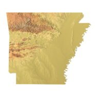
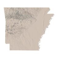
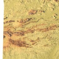
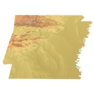
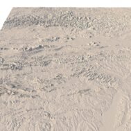
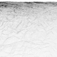
      The Arkansas Topographic Map STL model provides a high-resolution representation of the state’s topography and geographic features. Perfect for creating physical relief maps from wood, metal, plastic, or concrete, this 3D model offers detailed accuracy for a variety of uses, including landform visualization, education, and professional GIS projects. Whether you’re using a 3D printer, CNC machine, or laser engraver, this model ensures precise terrain representation.

      Features of the Arkansas Topographic STL Model

      • Detailed elevation data capturing Arkansas’ diverse landforms.
      • Compatible with FDM/SLA 3D printers for creating accurate terrain models.
      • Designed for CNC machining to craft wood or metal relief maps.
      • Supports high-precision laser engraving for metal surface detailing.

      Applications of the Arkansas Topographic Map STL

      This STL file is ideal for creating raised relief maps and terrain models of Arkansas’ landscape. Its applications range from landform visualization to educational models, making it an excellent tool for both hobbyists and professionals. With accurate elevation data, this model is also valuable for GIS and mapping projects.

      How to Use the Arkansas Terrain STL Model

      The Arkansas topographic map STL can be imported into CAD and GIS software for further customization. The high-resolution model ensures precise results when used for 3D printing, CNC machining, or laser engraving, making it a perfect solution for anyone needing a detailed representation of Arkansas’ terrain.

      Wooden 3D map
      Terrain 3D print
      3D map of wood
      3D natural wood map
      3D metal map
      Arkansas State Terrain Map 3D Model
      Arkansas Satellite Map

      Related products

      Afghanistan terrain map 3D printed in white plastic, showing elevation details
      Wooden Afghanistan relief map carved on CNC machine, natural finish

      Afghanistan Topographic Map – 3D Model for 3D Printing & CNC Carving

      $15.00
      Add to cart
      High-detail 3D terrain of Algeria with elevation data
      Accurate topographic contour lines in STL map of Algeria

      Algeria Topographic Map – 3D Model for 3D Printing & CNC Carving

      $15.00
      Add to cart
      Angola 3D STL terrain model with full topographic details
      Topographic contour lines of Angola in STL file

      Angola Topographic Map – 3D Terrain Model for Printing & CNC Carving

      $15.00
      Add to cart
      Asia STL model
      Asia 3D model

      Asia STL model

      $21.00
      Add to cart
      -30%
      Crete STL model
      Crete 3D model

      Crete Island STL model

      $20.00 Original price was: $20.00.$14.00Current price is: $14.00.
      Add to cart
      -19%
      France 3D Print model
      France 3D model

      France STL model

      $21.00 Original price was: $21.00.$17.00Current price is: $17.00.
      Add to cart
      -19%
      Jamaica STL model
      Jamaica 3D model

      Jamaica STL model

      $21.00 Original price was: $21.00.$17.00Current price is: $17.00.
      Add to cart
      -19%
      Japan STL model
      Japan 3D model

      Japan STL model

      $21.00 Original price was: $21.00.$17.00Current price is: $17.00.
      Add to cart
      -19%
      Jordan STL model
      Jordan 3D model

      Jordan STL model

      $21.00 Original price was: $21.00.$17.00Current price is: $17.00.
      Add to cart
      North America STL model
      North America 3D model

      North America STL model

      $21.00
      Add to cart
      INFO
      • About
      • Explore Our Terrain Services
      • Support
      • Shipping and delivery policy
      • Refund and Returns Policy
      • Privacy Policy
      • in**@***********ps.com
      • Blog
      How to buy
      • TERRAIN 3D MODELS FREE
      • Purchase with Crypto/PayPal/VISA
      • Buy on Cults3D.com
      • Buy on CGtrader.com
      • Buy on RenderHub.com
      • Buy on 3DExport.com
      • Discounts
      Buy 3D models
      • Planets
      • World
      • Continents
      • Peninsulas
      • Islands
      • Countries
      • States of America
      • Canadian Provinces
      • Canyons
      • Cities
      • Fantasy
      • Minecraft
      Buy 3D models for CNC
      • Planets
      • Continents
      • Islands
      • Countries
      • States of America

      DEM DSM DTM FBX OBJ STL

      SHUSTRIK-MAPS 2025
      • 3D MODELS
      • 3D PRINT/CNC MODELS
      • MAPS
      • FREE
      • About
      • FAQ
      • How to buy?
      • Site Map HTML
      • Explore Our Terrain Services
      Shopping cart
      Close
      Start typing to see products you are looking for.
      Your amount to pay has been updated
      The previous conversion quote has expired. Here is your new quote:
      Total
      $
      You Pay
      Back to checkout
      Place Order