info@shustrik-maps.com

Contact me


    Free conversion to OBJ/FBX/STL/C4D
    • Services
    • About
    • FAQ
    • Site Map
    • How to buy?
    info@shustrik-maps.com

    Contact me


      Logo shustrik maps
      • 3D MODELSOBJ/FBX/C4D
        • Solar System

          3D MODELS OF SOLAR SYSTEM OBJECTS

          Planets (11)

          11 products

          Satellites (1)

          1 product

          Space objects (3)

          3 products
        • World

          World (8)

          8 products

          North Pole (1)

          1 product

          South Pole (1)

          1 product

          Fantasy (2)

          2 products
        • Continents

          North America (2)

          2 products

          South America (2)

          2 products

          Europe (2)

          2 products

          Asia (1)

          1 product

          Africa (2)

          2 products

          Oceania (3)

          3 products

          Antarctica (1)

          1 product
        • Peninsulas

          Peninsulas (1)

          1 product
        • Islands

          Islands (13)

          13 products
        • Countries

          All countries →

          3D MODELS OF THE COUNTRIES

          A | B | C | D | E | 

          F | G | H | I | J | 

          K | L | M | N | O | 

          P | Q | R | S | T | 

          U | V | W | Y | Z | 

          3D MODELS OF COUNTRIES BY CONTINENT

          NORTH AMERICA

          • Northern America
          • Central America
          • Caribbean

          SOUTH AMERICA

          EUROPE

          • Western Europe
          • Northern Europe
          • Southern Europe
          • Eastern Europe

          AFRICA

          • Eastern Africa
          • Middle Africa
          • Northern Africa
          • Southern Africa
          • Western Africa

          ASIA

          • Central Asia
          • Eastern Asia
          • Southeast Asia
          • Southern Asia
          • Western Asia
        • States of America

          All states →

          UNITED STATES 3D MODELS

          Alabama

          • C4D/OBJ/BLEND 
          • STL
          • Satellite Map

          Alaska

          • STL


          Arizona

          • C4D/OBJ/BLEND 
          • STL
          • Satellite Map

          Arkansas

          • C4D/OBJ/BLEND 
          • STL
          • Satellite Map

          California

          • Tex 1: C4D/OBJ
          • Tex 2: C4D/OBJ
          • STL
          • Satellite Map

          Colorado

          • C4D/OBJ/BLEND
          • STL
          • Satellite Map

          Connecticut

          • STL
          • Satellite Map

          Delaware

          • STL
          • Satellite Map

          Florida

          • C4D/OBJ/BLEND
          • STL
          • Satellite Map

          Georgia

          • STL
          • Satellite Map

          Hawaii

          • C4D/OBJ/BLEND
          • STL


          Idaho

          • C4D/OBJ/BLEND
          • STL
          • Satellite Map

          Illinois

          • STL
          • Satellite Map

          Indiana

          • C4D/OBJ/BLEND
          • STL
          • Satellite Map

          Iowa

          • C4D/OBJ/BLEND
          • STL
          • Satellite Map

          Kansas

          • C4D/OBJ/BLEND
          • STL
          • Satellite Map

          Kentucky

          • STL
          • Satellite Map

          Louisiana

          • STL
          • Satellite Map

          Maine

          • STL
          • Satellite Map

          Maryland

          • STL
          • Satellite Map

          Massachusetts

          • STL
          • Satellite Map

          Michigan

          • STL

          Minnesota

          • STL


          Mississippi

          • STL

          Missouri

          • STL

          Montana

          • Tex 1: C4D/OBJ
          • Tex 1: C4D/OBJ
          • STL

          Nebraska

          • C4D/OBJ/BLEND
          • STL


          Nevada

          • C4D/OBJ/BLEND
          • STL


          New Hampshire

          • STL


          New Jersey

          • STL

          New Mexico

          • C4D/OBJ/BLEND
          • STL

          New York

          • STL


          North Carolina

          • STL

          North Dakota

          • C4D/OBJ/BLEND
          • STL

          Ohio

          • STL


          Oklahoma

          • STL

          Oregon

          • C4D/OBJ/BLEND
          • STL

          Pennsylvania

          • STL


          Rhode Island

          • STL

          South Carolina

          • STL

          South Dakota

          • C4D/OBJ/BLEND
          • STL

          Tennessee

          • STL


          Texas

          • C4D/OBJ/BLEND
          • STL

          Utah

          • C4D/OBJ/BLEND
          • STL


          Vermont

          • STL


          Virginia

          • STL

          Washington

          • C4D/OBJ/BLEND
          • STL

          West Virginia

          • STL


          Wisconsin

          • STL

          Wyoming

          • C4D/OBJ/BLEND
          • STL
        • Canadian Provinces

          CANADIAN PROVINCES 3D MODELS

          Alberta

          British Columbia

          Manitoba

          New Brunswick

          Newfoundland

          Nova Scotia

          Ontario

          Prince Edward

          Quebec

          Saskatchewan

          CANADIAN TERRITORIES 3D MODELS

          Northwest Territories

          Nunavut

          Yukon

        • Parks & Canyons

          3D MODELS OF NATIONAL PARKS AND CANYONS

          Canyons (2)

          2 products
        • Other

          ART (6)

          6 products
      • 3D PRINT/CNC MODELSSTL
        • Planets
        • Satellites
        • Continents
        • Countries
        • Islands
        • States of America
        • Fantasy
        • Other
      • MAPSTIF/PSD/SVG
        • Satellite Maps
        • Night Satellite Map
        • Heightmaps/Raster DEM
        • Relief Maps
        • 3D Maps
        • Historical Maps
        • Outline Maps
      • FREE
      • SERVICES
      • A-Z
      Search
      0 items / $0.00
      Menu
      3D Models and 3D Maps
      0 items / $0.00
      3D model of Alabama topographic map showing detailed elevation and contour lines.
      Alabama terrain model prepared for CNC machining and 3D printing, showcasing geographical features.
      STL model of Alabama topography displaying accurate elevation data for 3D printing and CNC.
      State of Alabama stl files for 3d printing
      State of Alabama buy 3d models
      State of Alabama 3d relief cnc files
      State of Alabama 3D Print model
      Click to enlarge
      3D model of Alabama topographic map showing detailed elevation and contour lines.
      Alabama terrain model prepared for CNC machining and 3D printing, showcasing geographical features.
      STL model of Alabama topography displaying accurate elevation data for 3D printing and CNC.
      State of Alabama stl files for 3d printing
      State of Alabama buy 3d models
      State of Alabama 3d relief cnc files
      State of Alabama 3D Print model
      Home 3D PRINT/CNC MODELS States of America Alabama Topographic Map STL Model
      Dominican Republic STL model
      Dominican Republic STL model $21.00 Original price was: $21.00.$17.00Current price is: $17.00.
      Back to products
      Alaska STL model
      State of Alaska STL model $21.00

      Alabama Topographic Map STL Model

      $21.00

      • Format: STL
      • Files size: 801 MB/419 MB
      •  Polygons: 16 815 236
      •  Vertices: 8 419 743
      •  Geometry: Polygonal Tris only
      • Model size: 159.48 mm x 251.88 mm x 0.991 mm
      • Projection: Mercator
      •  Scaling factor X:Y:Z: 1:1:3
      • Base: Open/Closed

      We accept VISA, Mastercard, ApplePay, GooglePay and other payment methods

      — OR —

      You can also purchase this product using MasterCard/Visa on
      RenderHub →  and 3Dexport →.

      SKU: SH_6779 Categories: 3D PRINT/CNC MODELS, States of America Tags: Mercator, States, STL
      Share:
      • Description
      Description

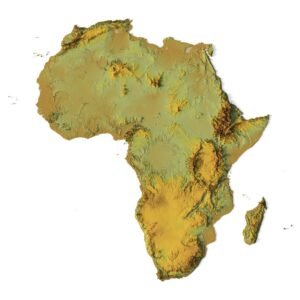
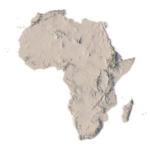
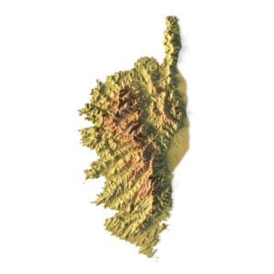
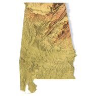
      Create Detailed Topography with this 3D STL Model

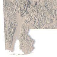
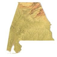
      This Alabama topographic map STL model is perfect for those who need a high-precision terrain model. Whether you’re a professional in geospatial analysis, an enthusiast in 3D printing, or someone interested in landscape representation, this model will help bring the natural features of Alabama to life.

      Key Features of the Alabama Topographic Map STL

      • Supports FDM/SLA 3D printers for plastic or photopolymer models.
      • Compatible with CNC machines for wood or metal terrain models.
      • Precise 3D laser engraving for metal surface detailing.

      Wide Applications of the Topographic Map STL Model

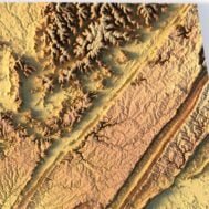
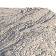
      This model is ideal for creating raised relief maps and physical models using a range of materials such as wood, metal, plastic, and concrete. It allows the user to visually explore the geographical features and terrain of Alabama, providing a powerful tool for education, design, and more.

      How to Use the Alabama Terrain STL Model

      The Alabama topographic map is designed to work with popular mapping software and can be adapted for further customization in various CAD tools. Its high-resolution digital elevation model (DEM) makes it perfect for professional uses or DIY projects. Whether for 3D printing, CNC routing, or laser engraving, this model ensures accurate and beautiful terrain creation.

      Wooden 3D map
      Terrain 3D print
      3D map of wood
      3D natural wood map
      3D metal map
        Alabama 3D Model
        Alabama Satellite Map

        Related products

        Afghanistan terrain map 3D printed in white plastic, showing elevation details
        Wooden Afghanistan relief map carved on CNC machine, natural finish

        Afghanistan Topographic Map – 3D Model for 3D Printing & CNC Carving

        $15.00
        Add to cart
        3D STL model of Africa’s topography, showing elevation contours and landform details for terrain visualization and 3D printing.
        High-precision topographic map of Africa designed for CNC machining, ideal for creating relief models in wood or metal.

        Africa Topo Map STL Model

        $21.00
        Add to cart
        High-detail 3D terrain of Algeria with elevation data
        Accurate topographic contour lines in STL map of Algeria

        Algeria Topographic Map – 3D Model for 3D Printing & CNC Carving

        $15.00
        Add to cart
        Full topographic STL model of Armenia with elevation features
        Detailed 3D terrain of Armenia with contour line structure

        Armenia Topographic Map – 3D Terrain Model for Printing & CNC Carving

        $15.00
        Add to cart
        3D terrain model of Belgium in STL format, front view
        STL file of Belgium map for CNC and 3D printing

        Belgium Topographic Map – 3D Model for 3D Printing & CNC Carving

        $15.00
        Add to cart
        -30%
        Corsica terrain 3D model
        Corsica 3D model

        Corsica Island STL model

        $20.00 Original price was: $20.00.$14.00Current price is: $14.00.
        Add to cart
        -30%
        Crete STL model
        Crete 3D model

        Crete Island STL model

        $20.00 Original price was: $20.00.$14.00Current price is: $14.00.
        Add to cart
        -19%
        France 3D Print model
        France 3D model

        France STL model

        $21.00 Original price was: $21.00.$17.00Current price is: $17.00.
        Add to cart
        -19%
        Kuwait STL model
        Kuwait 3D model

        Kuwait STL model

        $21.00 Original price was: $21.00.$17.00Current price is: $17.00.
        Add to cart
        3D model of Georgia’s topographic map showing elevation data
        Topographic terrain model of Georgia for 3D printing and CNC machining, with detailed contours.

        Topographic Map of Georgia USA STL Model

        $21.00
        Add to cart
          INFO
          • About
          • Explore Our Terrain Services
          • Support
          • Shipping and delivery policy
          • Refund and Returns Policy
          • Privacy Policy
          • in**@***********ps.com
          • Blog
          How to buy
          • TERRAIN 3D MODELS FREE
          • Purchase with Crypto/PayPal/VISA
          • Buy on Cults3D.com
          • Buy on CGtrader.com
          • Buy on RenderHub.com
          • Buy on 3DExport.com
          • Discounts
          Buy 3D models
          • Planets
          • World
          • Continents
          • Peninsulas
          • Islands
          • Countries
          • States of America
          • Canadian Provinces
          • Canyons
          • Cities
          • Fantasy
          • Minecraft
          Buy 3D models for CNC
          • Planets
          • Continents
          • Islands
          • Countries
          • States of America

          DEM DSM DTM FBX OBJ STL

          SHUSTRIK-MAPS 2025
          • 3D MODELS
            • Solar System
            • World
            • Continents
            • Peninsulas
            • Islands
            • Countries
            • States of America
            • Canadian Provinces
            • Canyons
            • Buildings
            • Fantasy
            • ART
          • 3D PRINT/CNC MODELS
            • Planets
            • Satellites
            • Continents
            • Countries
            • Islands
            • States of America
            • Fantasy
            • Other
          • MAPS
          • A-Z
          • FREE
          • About
          • FAQ
          • How to buy?
          • Site Map HTML
          • Explore Our Terrain Services
          Shopping cart
          Close
          Start typing to see products you are looking for.
          Your amount to pay has been updated
          The previous conversion quote has expired. Here is your new quote:
          Total
          $
          You Pay
          Back to checkout
          Place Order