info@shustrik-maps.com

Contact me


    Free conversion to OBJ/FBX/STL/C4D
    • Services
    • About
    • FAQ
    • Site Map
    • How to buy?
    info@shustrik-maps.com

    Contact me


      Logo shustrik maps
      • 3D MODELSOBJ/FBX/C4D
        • Solar System

          3D MODELS OF SOLAR SYSTEM OBJECTS

          Planets (11)

          11 products

          Satellites (1)

          1 product

          Space objects (3)

          3 products
        • World

          World (8)

          8 products

          North Pole (1)

          1 product

          South Pole (1)

          1 product

          Fantasy (2)

          2 products
        • Continents

          North America (2)

          2 products

          South America (2)

          2 products

          Europe (2)

          2 products

          Asia (1)

          1 product

          Africa (2)

          2 products

          Oceania (3)

          3 products

          Antarctica (1)

          1 product
        • Peninsulas

          Peninsulas (1)

          1 product
        • Islands

          Islands (13)

          13 products
        • Countries

          All countries →

          3D MODELS OF THE COUNTRIES

          A | B | C | D | E | 

          F | G | H | I | J | 

          K | L | M | N | O | 

          P | Q | R | S | T | 

          U | V | W | Y | Z | 

          3D MODELS OF COUNTRIES BY CONTINENT

          NORTH AMERICA

          • Northern America
          • Central America
          • Caribbean

          SOUTH AMERICA

          EUROPE

          • Western Europe
          • Northern Europe
          • Southern Europe
          • Eastern Europe

          AFRICA

          • Eastern Africa
          • Middle Africa
          • Northern Africa
          • Southern Africa
          • Western Africa

          ASIA

          • Central Asia
          • Eastern Asia
          • Southeast Asia
          • Southern Asia
          • Western Asia
        • States of America

          All states →

          UNITED STATES 3D MODELS

          Alabama

          • C4D/OBJ/BLEND 
          • STL
          • Satellite Map

          Alaska

          • STL


          Arizona

          • C4D/OBJ/BLEND 
          • STL
          • Satellite Map

          Arkansas

          • C4D/OBJ/BLEND 
          • STL
          • Satellite Map

          California

          • Tex 1: C4D/OBJ
          • Tex 2: C4D/OBJ
          • STL
          • Satellite Map

          Colorado

          • C4D/OBJ/BLEND
          • STL
          • Satellite Map

          Connecticut

          • STL
          • Satellite Map

          Delaware

          • STL
          • Satellite Map

          Florida

          • C4D/OBJ/BLEND
          • STL
          • Satellite Map

          Georgia

          • STL
          • Satellite Map

          Hawaii

          • C4D/OBJ/BLEND
          • STL


          Idaho

          • C4D/OBJ/BLEND
          • STL
          • Satellite Map

          Illinois

          • STL
          • Satellite Map

          Indiana

          • C4D/OBJ/BLEND
          • STL
          • Satellite Map

          Iowa

          • C4D/OBJ/BLEND
          • STL
          • Satellite Map

          Kansas

          • C4D/OBJ/BLEND
          • STL
          • Satellite Map

          Kentucky

          • STL
          • Satellite Map

          Louisiana

          • STL
          • Satellite Map

          Maine

          • STL
          • Satellite Map

          Maryland

          • STL
          • Satellite Map

          Massachusetts

          • STL
          • Satellite Map

          Michigan

          • STL

          Minnesota

          • STL


          Mississippi

          • STL

          Missouri

          • STL

          Montana

          • Tex 1: C4D/OBJ
          • Tex 1: C4D/OBJ
          • STL

          Nebraska

          • C4D/OBJ/BLEND
          • STL


          Nevada

          • C4D/OBJ/BLEND
          • STL


          New Hampshire

          • STL


          New Jersey

          • STL

          New Mexico

          • C4D/OBJ/BLEND
          • STL

          New York

          • STL


          North Carolina

          • STL

          North Dakota

          • C4D/OBJ/BLEND
          • STL

          Ohio

          • STL


          Oklahoma

          • STL

          Oregon

          • C4D/OBJ/BLEND
          • STL

          Pennsylvania

          • STL


          Rhode Island

          • STL

          South Carolina

          • STL

          South Dakota

          • C4D/OBJ/BLEND
          • STL

          Tennessee

          • STL


          Texas

          • C4D/OBJ/BLEND
          • STL

          Utah

          • C4D/OBJ/BLEND
          • STL


          Vermont

          • STL


          Virginia

          • STL

          Washington

          • C4D/OBJ/BLEND
          • STL

          West Virginia

          • STL


          Wisconsin

          • STL

          Wyoming

          • C4D/OBJ/BLEND
          • STL
        • Canadian Provinces

          CANADIAN PROVINCES 3D MODELS

          Alberta

          British Columbia

          Manitoba

          New Brunswick

          Newfoundland

          Nova Scotia

          Ontario

          Prince Edward

          Quebec

          Saskatchewan

          CANADIAN TERRITORIES 3D MODELS

          Northwest Territories

          Nunavut

          Yukon

        • Parks & Canyons

          3D MODELS OF NATIONAL PARKS AND CANYONS

          Canyons (2)

          2 products
        • Other

          ART (4)

          4 products
      • 3D PRINT/CNC MODELSSTL
        • Planets
        • Satellites
        • Continents
        • Countries
        • Islands
        • States of America
        • Fantasy
        • Other
      • MAPSTIF/PSD/SVG
        • Satellite Maps
        • Night Satellite Map
        • Heightmaps/Raster DEM
        • Relief Maps
        • 3D Maps
        • Historical Maps
        • Outline Maps
      • FREE
      • SERVICES
      • A-Z
      Search
      0 items / $0.00
      Menu
      3D Models and 3D Maps
      0 items / $0.00
      Antarctica terrain 3D model
      Antarctica terrain 3D model
      Antarctica STL model
      Antarctica 3D model
      A detailed view of Antarctica's elevation map with visible contours and terrain variations.
      A topographic representation showing the glaciers and ice sheets in Antarctica's terrain.
      Antarctica relief map
      Antarctica 3D elevation model
      A relief map highlighting Antarctica’s major landforms and elevation contours.
      A high-resolution Antarctica terrain map displaying its unique topography and elevation changes.
      Antarctica terrain
      Antarctica 3D Print model
      Antarctica 3d relief cnc files
      Antarctica stl files for 3d printing
      Antarctica 3D model
      Antarctica model C4D OBJ STL
      Antarctica Aspire
      Click to enlarge
      Antarctica terrain 3D model
      Antarctica terrain 3D model
      Antarctica STL model
      Antarctica 3D model
      A detailed view of Antarctica's elevation map with visible contours and terrain variations.
      A topographic representation showing the glaciers and ice sheets in Antarctica's terrain.
      Antarctica relief map
      Antarctica 3D elevation model
      A relief map highlighting Antarctica’s major landforms and elevation contours.
      A high-resolution Antarctica terrain map displaying its unique topography and elevation changes.
      Antarctica terrain
      Antarctica 3D Print model
      Antarctica 3d relief cnc files
      Antarctica stl files for 3d printing
      Antarctica 3D model
      Antarctica model C4D OBJ STL
      Antarctica Aspire
      Home 3D MODELS World South Pole Antarctica Elevation Map 3D Model
      New Zealand terrain 3D model
      New Zealand Elevation 3D Model $28.00
      Back to products
      Portugal 3d print stl
      3D model of Portugal terrain $28.00

      Antarctica Elevation Map 3D Model

      $28.00

      Antarctica Elevation and Topographic Map: A Detailed 3D Model

      3D model

      • Format: C4D / STL (export to OBJ/FBX on request)
      • File size: 1.1 GB / 547 MB
      • Polygons: 19 776 644
      • Vertices: 9 895 415
      • Geometry: Polygonal Tris only
      • Model size: 886.5 mm x 886.5 mm x 27.636 mm
      • Projection: Polar Stereographic
      • Base: Open / Closed

      Textures

      • Format: TIF
      • File size: 927 MB
      • Resolution: 18000*18000*24b
      • UV layer: yes

      We accept VISA, Mastercard, ApplePay, GooglePay and other payment methods

      — OR —

      You can also purchase this product using MasterCard/Visa on
      RenderHub →  and 3Dexport →.

      SKU: SH_2439 Categories: Antarctica, Continents, South Pole Tags: C4D, Continents
      Share:
      • Description
      Description

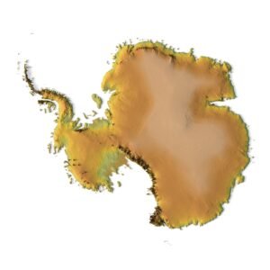
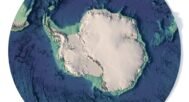
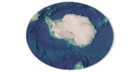
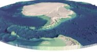
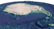
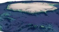
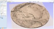
      Explore the Antarctic continent in stunning detail with our 3D Antarctica elevation map. This model provides a highly accurate representation of the continent’s topography, including detailed elevation data and landform contours.

      Why Choose Our Antarctica Elevation Map?

      Our 3D model offers an in-depth look at Antarctica’s terrain, including its unique glaciers, ice sheets, and other major landforms. Whether you’re an academic, geographer, or hobbyist, this topographic map is the perfect tool for understanding the average elevation of Antarctica.

      Key Features of the 3D Antarctica Topographic Map

      • Elevation Data: Accurate elevation levels across the entire continent.
      • Contour Lines: Detailed contours showcasing the terrain and altitude variations.
      • Landforms: Key landforms such as glaciers and ice formations are meticulously represented.
      • Relief Map Visualization: A high-quality relief map that highlights height variations.
      • 3D Terrain Visualization: Offers a true sense of Antarctica’s height map and surface conditions.

      Versatile Use Cases for Antarctic Terrain Exploration

      Our Antarctica topography map is suitable for educational, research, and creative projects. Whether you’re studying the terrain of Antarctica or creating a visual display, this 3D model provides the accuracy and depth you need.

      Ideal for Scientists and Enthusiasts Alike

      Get a closer look at the elevation changes and terrain features that define the most remote continent on Earth. This elevation map offers an exceptional way to visualize and study the landscape of Antarctica.

      Download and Explore Antarctica’s Elevation in Detail

      Order now and download your Antarctica elevation map today. With easy integration into various platforms, this model brings the icy continent’s topography right to your fingertips.

      Antarctica Cinema 4D

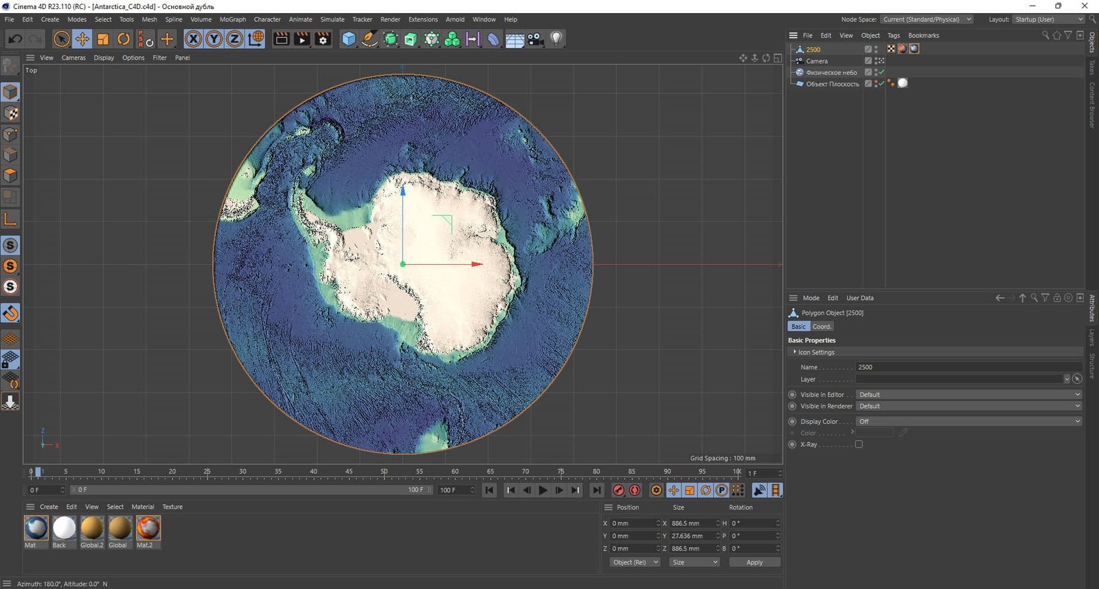
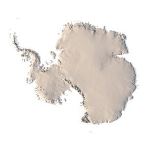
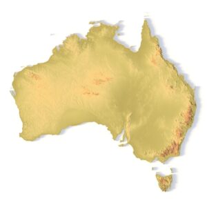
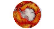
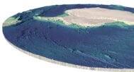
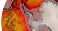
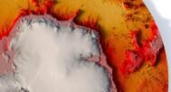
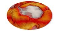
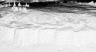
      In addition to the 3D terrain model of South Pole, I can attach a map of heights and various satellite textures.
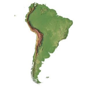
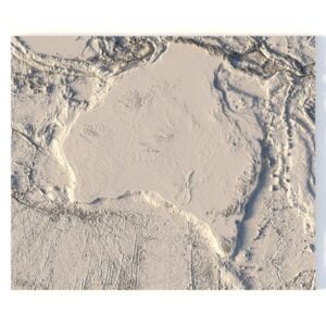
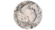
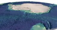
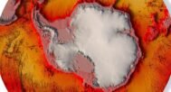
      South Pole DEM

      A 3D visualization of Antarctica's height map, showcasing varying elevation levels.

      The elevation map is used to get information about low and high parts of the South Pole relief.

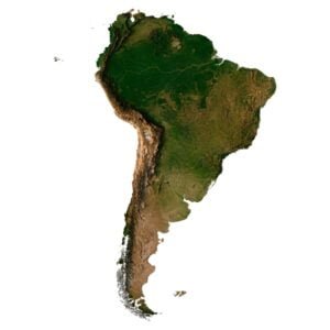
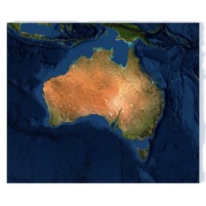
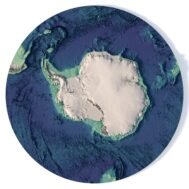
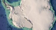
      Satellite image of South Pole

      Satellite imagery of Antarctica

      The satellite texture is high resolution in TIF format.

      Have a Question?

      Do you need an extra high resolution 3D terrain of South Pole?
      Do you need Shapefile of South Pole and regions?
      Do you need more resolution satellite Antarctica images?
      Do you need a 3D models of Antarctica in BLEND, OBJ or FBX format?
      WRITE A MESSAGE
      Antarctica 3D model (STL)
      North Pole 3D model

      Related products

      South America terrain 3D model
      South America 3D model

      3D map of South America C4D model

      $28.00
      Add to cart
      Africa 3D model terrain
      3D relief map of Africa

      Africa Map 3D Model

      $35.00
      Add to cart
      Antarctica STL model
      Antarctica 3D model

      Antarctica 3D model

      $21.00
      Add to cart
      Asia STL model
      Asia 3D model

      Asia STL model

      $21.00
      Add to cart
      Australia terrain 3D model
      Australia terrain 3D model

      Australia terrain 3D model

      $28.00
      Add to cart
      Printable 3D terrain model of Australia with elevation detail
      CNC-compatible STL map of Australia’s landforms

      Australia Topographic Map – 3D Model for 3D Printing & CNC Carving

      $15.00
      Add to cart
      Italy terrain 3D model
      Italy 3D model

      Italy terrain 3D model

      $28.00
      Add to cart
      -27%
      Minsk City 3D model

      Minsk City 3D model

      $10.00 Original price was: $10.00.$7.30Current price is: $7.30.
      Add to cart
      North America STL model
      North America 3D model

      North America Lambert Conformal Conic STL model

      $21.00
      Add to cart
      Ukraine 3D model
      Ukraine 3D model

      Ukraine map 3D model

      $28.00
      Add to cart
        INFO
        • About
        • Explore Our Terrain Services
        • Support
        • Shipping and delivery policy
        • Refund and Returns Policy
        • Privacy Policy
        • in**@***********ps.com
        • Blog
        How to buy
        • TERRAIN 3D MODELS FREE
        • Purchase with Crypto/PayPal/VISA
        • Buy on Cults3D.com
        • Buy on CGtrader.com
        • Buy on RenderHub.com
        • Buy on 3DExport.com
        • Discounts
        Buy 3D models
        • Planets
        • World
        • Continents
        • Peninsulas
        • Islands
        • Countries
        • States of America
        • Canadian Provinces
        • Canyons
        • Cities
        • Fantasy
        • Minecraft
        Buy 3D models for CNC
        • Planets
        • Continents
        • Islands
        • Countries
        • States of America

        DEM DSM DTM FBX OBJ STL

        SHUSTRIK-MAPS 2025
        • 3D MODELS
          • Solar System
          • World
          • Continents
          • Peninsulas
          • Islands
          • Countries
          • States of America
          • Canadian Provinces
          • Canyons
          • Buildings
          • Fantasy
          • ART
        • 3D PRINT/CNC MODELS
          • Planets
          • Satellites
          • Continents
          • Countries
          • Islands
          • States of America
          • Fantasy
          • Other
        • MAPS
        • A-Z
        • FREE
        • About
        • FAQ
        • How to buy?
        • Site Map HTML
        • Explore Our Terrain Services
        Shopping cart
        Close
        Start typing to see products you are looking for.
        Your amount to pay has been updated
        The previous conversion quote has expired. Here is your new quote:
        Total
        $
        You Pay
        Back to checkout
        Place Order