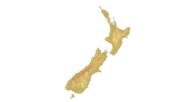
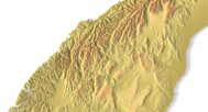
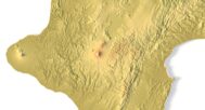
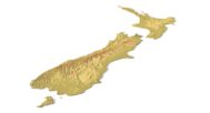
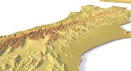

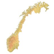
Topographic map New Zealand STL model
Original price was: $21.00.$17.00Current price is: $17.00.
Topographic Map of New Zealand in STL Format for 3D Printing and CNC Machining
![]()
- File size: 110 MB
- Polygons: 2 316 642
- Vertices: 1 158 433
- Geometry: Polygonal Tris only
- Model size: 153 mm x 220 mm x 1.2 mm
- Projection: Mercator
- Scaling factor X:Y:Z: 1:1:2
- Base: Closed
Explore detailed 3D terrain with our topographic map of New Zealand, perfect for landscape mapping and terrain analysis. This high-quality STL model captures precise contour lines and elevation data, allowing you to create accurate physical models of New Zealand’s diverse landscapes.
Uses for New Zealand Topographic STL Model
Our topographic map of New Zealand is designed for a range of applications:
- 3D Printing: Ideal for FDM and SLA printers to produce topographical landscapes in plastic or photopolymer.
- CNC Machining: Compatible with CNC machines for creating detailed reliefs in wood or metal.
- High precision laser engraving on metals with 3D laser markers.
Elevate Your Geospatial Modeling with Precise Data
This STL model provides detailed digital elevation data, perfect for geospatial modeling and topography visualization. It’s ideal for professionals in GIS data processing or for educational purposes in terrain analysis and landform representation.
Download and Customize Your Topographic Map
Download the NZ topo map in STL format and adjust it to fit your specific project needs. The model supports a variety of uses, from simple terrain visualization to more complex geospatial modeling and landscape studies.
Why Choose Our Topographic Map of New Zealand?
- Accuracy: Detailed contour lines and elevation details, essential for precise landscape mapping.
- Versatility: Perfect for both 3D printing and CNC machining.
- Customizable: Modify the STL to suit your project specifications, whether for physical models or digital representation.


Why choose this model?
✔ Realistic Topography Based on Geospatial Data
Built from a digital elevation model (DEM) for real-world accuracy. Perfect for 3D terrain visualization and mapping projects.
✔ Ready for 3D Printing and CNC Machining
Clean STL file optimized for printing in PLA, resin, wood, aluminum, and more. Usable at different scales.
✔ Designed for Education, Design & Creativity
Use this model in geography classes, architecture layouts, art pieces, and custom souvenir production.
Sample Use Cases:
3D print a raised-relief map of New Zealand for geography lessons
CNC carve the Southern Alps into wood or metal for educational panels
Create an elevation-aware terrain layout for architectural planning
Produce NZ-themed wall art or display models
Design unique gifts and geographic jewelry
FAQ
The description includes scaling factors for each axis. For example, if you see X – 0.001, Y – 0.001, Z – 0.003, this means the height is three times greater than the width and length. We scale height this way to emphasize the relief.
If you need uniform proportions, let us know—we’ll prepare a custom model upon request.
Send us your required specifications, and we’ll adapt the model accordingly.
Yes, we check every model for integrity and errors.
Yes. For better surface quality, we recommend printing it vertically.
Larger models require more polygons to preserve relief detail. Provide your desired dimensions, and we’ll prepare:
A single optimized model or
A segmented version with high resolution.
Yes, but polygon reduction may be necessary. Submit a request with your project’s dimensions for a tailored solution.