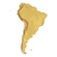
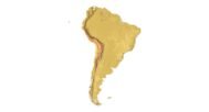
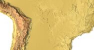
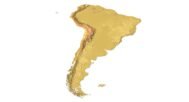
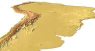
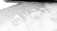

South America 3D STL Map – Topographic Model for 3D Printing & CNC
$21.00
![]()
- File size: 222 MB
- Model size: 155 mm x 218 mm x 1.5 mm
- Projection: Mercator
- Scaling factor: X — 0,001; Y — 0,001; Z — 0,003
- Polygons: 4 676 264
- Vertices: 2 338 329
- Geometry: Polygonal Tris only
- Base: Closed
South America 3D STL Map – High-Resolution Topographic Model for 3D Printing, CNC & Digital Projects
South America 3D STL Map is a high-resolution topographic 3D model in STL format, optimized for 3D printing, CNC machining, laser cutting, and digital rendering. This South America STL model provides accurate geographic relief data of the continent as a ready-to-use STL file for makers, engineers, designers, educators, and hobbyists.
STL model of South America can be used for various purposes:
- Making physical models from plastic or photopolymer using 3D printers
- Making models of wood or metal using CNC machines
- Making a high-resolution relief using 3D laser markers
- Making of “master forms” for duplication of products using foam polystyrene or concrete
- Creating computer graphics
- Creation of low-polygonal models for computer games


How do I change the parameters of the STL model of South America?
You can easily resize the model in any program that allows you to import STL files.
In addition to changing the scale in width, length, and height, you can add a higher base. You can also use anti-aliasing tools, add bulk text, reduce the number of polygons, etc.