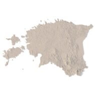
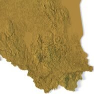
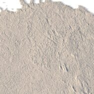
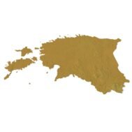
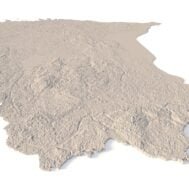
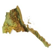
info@shustrik-maps.com

Contact me


    Free conversion to OBJ/FBX/STL/C4D
    • Services
    • About
    • FAQ
    • Site Map
    • How to buy?
    info@shustrik-maps.com

    Contact me


      Logo shustrik maps
      • 3D MODELSOBJ/FBX/C4D
        • Solar System

          3D MODELS OF SOLAR SYSTEM OBJECTS

          Planets (11)

          11 products

          Satellites (1)

          1 product

          Space objects (3)

          3 products
        • World

          World (8)

          8 products

          North Pole (1)

          1 product

          South Pole (1)

          1 product

          Fantasy (2)

          2 products
        • Continents

          North America (2)

          2 products

          South America (2)

          2 products

          Europe (2)

          2 products

          Asia (1)

          1 product

          Africa (2)

          2 products

          Oceania (3)

          3 products

          Antarctica (1)

          1 product
        • Peninsulas

          Peninsulas (1)

          1 product
        • Islands

          Islands (13)

          13 products
        • Countries

          All countries →

          3D MODELS OF THE COUNTRIES

          A | B | C | D | E | 

          F | G | H | I | J | 

          K | L | M | N | O | 

          P | Q | R | S | T | 

          U | V | W | Y | Z | 

          3D MODELS OF COUNTRIES BY CONTINENT

          NORTH AMERICA

          • Northern America
          • Central America
          • Caribbean

          SOUTH AMERICA

          EUROPE

          • Western Europe
          • Northern Europe
          • Southern Europe
          • Eastern Europe

          AFRICA

          • Eastern Africa
          • Middle Africa
          • Northern Africa
          • Southern Africa
          • Western Africa

          ASIA

          • Central Asia
          • Eastern Asia
          • Southeast Asia
          • Southern Asia
          • Western Asia
        • States of America

          All states →

          UNITED STATES 3D MODELS

          Alabama

          • C4D/OBJ/BLEND 
          • STL
          • Satellite Map

          Alaska

          • STL


          Arizona

          • C4D/OBJ/BLEND 
          • STL
          • Satellite Map

          Arkansas

          • C4D/OBJ/BLEND 
          • STL
          • Satellite Map

          California

          • Tex 1: C4D/OBJ
          • Tex 2: C4D/OBJ
          • STL
          • Satellite Map

          Colorado

          • C4D/OBJ/BLEND
          • STL
          • Satellite Map

          Connecticut

          • STL
          • Satellite Map

          Delaware

          • STL
          • Satellite Map

          Florida

          • C4D/OBJ/BLEND
          • STL
          • Satellite Map

          Georgia

          • STL
          • Satellite Map

          Hawaii

          • C4D/OBJ/BLEND
          • STL


          Idaho

          • C4D/OBJ/BLEND
          • STL
          • Satellite Map

          Illinois

          • STL
          • Satellite Map

          Indiana

          • C4D/OBJ/BLEND
          • STL
          • Satellite Map

          Iowa

          • C4D/OBJ/BLEND
          • STL
          • Satellite Map

          Kansas

          • C4D/OBJ/BLEND
          • STL
          • Satellite Map

          Kentucky

          • STL
          • Satellite Map

          Louisiana

          • STL
          • Satellite Map

          Maine

          • STL
          • Satellite Map

          Maryland

          • STL
          • Satellite Map

          Massachusetts

          • STL
          • Satellite Map

          Michigan

          • STL

          Minnesota

          • STL


          Mississippi

          • STL

          Missouri

          • STL

          Montana

          • Tex 1: C4D/OBJ
          • Tex 1: C4D/OBJ
          • STL

          Nebraska

          • C4D/OBJ/BLEND
          • STL


          Nevada

          • C4D/OBJ/BLEND
          • STL


          New Hampshire

          • STL


          New Jersey

          • STL

          New Mexico

          • C4D/OBJ/BLEND
          • STL

          New York

          • STL


          North Carolina

          • STL

          North Dakota

          • C4D/OBJ/BLEND
          • STL

          Ohio

          • STL


          Oklahoma

          • STL

          Oregon

          • C4D/OBJ/BLEND
          • STL

          Pennsylvania

          • STL


          Rhode Island

          • STL

          South Carolina

          • STL

          South Dakota

          • C4D/OBJ/BLEND
          • STL

          Tennessee

          • STL


          Texas

          • C4D/OBJ/BLEND
          • STL

          Utah

          • C4D/OBJ/BLEND
          • STL


          Vermont

          • STL


          Virginia

          • STL

          Washington

          • C4D/OBJ/BLEND
          • STL

          West Virginia

          • STL


          Wisconsin

          • STL

          Wyoming

          • C4D/OBJ/BLEND
          • STL
        • Canadian Provinces

          CANADIAN PROVINCES 3D MODELS

          Alberta

          British Columbia

          Manitoba

          New Brunswick

          Newfoundland

          Nova Scotia

          Ontario

          Prince Edward

          Quebec

          Saskatchewan

          CANADIAN TERRITORIES 3D MODELS

          Northwest Territories

          Nunavut

          Yukon

        • Parks & Canyons

          3D MODELS OF NATIONAL PARKS AND CANYONS

          Canyons (2)

          2 products
        • Other

          ART (4)

          4 products
      • 3D PRINT/CNC MODELSSTL
        • Planets
        • Satellites
        • Continents
        • Countries
        • Islands
        • States of America
        • Fantasy
        • Other
      • MAPSTIF/PSD/SVG
        • Satellite Maps
        • Night Satellite Map
        • Heightmaps/Raster DEM
        • Relief Maps
        • 3D Maps
        • Historical Maps
        • Outline Maps
      • FREE
      • SERVICES
      • A-Z
      Search
      0 items / $0.00
      Menu
      3D Models and 3D Maps
      0 items / $0.00
      -19%
      Estonia STL model
      Estonia 3D model
      Estonia buy 3d models
      Estonia 3D map
      Estonia relief map
      Estonia 3D Print model
      Estonia 3d relief cnc files
      Click to enlarge
      Estonia STL model
      Estonia 3D model
      Estonia buy 3d models
      Estonia 3D map
      Estonia relief map
      Estonia 3D Print model
      Estonia 3d relief cnc files
      Home 3D PRINT/CNC MODELS Countries Estonia STL model
      Eritrea STL model
      Eritrea STL model $21.00 Original price was: $21.00.$17.00Current price is: $17.00.
      Back to products
      Ethiopia STL model
      Ethiopia STL model $21.00 Original price was: $21.00.$17.00Current price is: $17.00.

      Estonia STL model

      $21.00 Original price was: $21.00.$17.00Current price is: $17.00.

      High-polygon 3D model of Estonia in STL format

      • File size: 510 MB
      • Model size: 71.625 mm х 46.3 mm х 0.371 mm
      • Resolution: 0,025 mm
      • Projection: Mercator
      • Scaling factor: X — 0,0000001; Y — 0,0000001; Z — 0,000001
      • Polygons: 10 709 340
      • Vertices: 5 354 942
      • Geometry: Polygonal Tris only
      • Base: Closed
      [idcore id=”142″]

      We accept VISA, Mastercard, ApplePay, GooglePay and other payment methods

      — OR —

      You can also purchase this product using MasterCard/Visa on
      RenderHub →  and 3Dexport →.

      SKU: SH_6617 Categories: 3D PRINT/CNC MODELS, Countries Tags: Countries, E, Mercator, Northern Europe, STL
      Share:
      • Description
      Description

      Estonia is located in Northern Europe along the coast of the Baltic Sea and the Gulf of Riga. It borders just two countries including Latvia to the south and Russia to the east. It’s also separated by the Gulf of Finland with Scandinavia (Finland and Sweden) to the north. Tallinn is the capital and largest city in Estonia, just along the Gulf of Finland in the north. But Tartu has also been considered the cultural capital as well. It consists of several islands on the West Coast. Specifically, Saaremaa and Hiiumaa are the two largest islands. But also Muhu, Vormsi, and Naissaar are smaller islands also off mainland Estonia.

      What can I use a 3D model in STL format for?

      STL model of Estonia can be used for various purposes:

      • Making physical models from plastic or photopolymer using 3D printers
      • Making models of wood or metal using CNC machines
      • Making a high-resolution relief using 3D laser markers
      • Making of “master forms” for duplication of products using foam polystyrene or concrete
      • Creating computer graphics
      • Creation of low-polygonal models for computer games
      Wooden 3D map
      Terrain 3D print
      3D map of wood
      3D natural wood map
      3D metal map

        What is the resolution of the 3D model of Estonia?

        With the development of technology, it is becoming possible to produce more and more precise relief models.

        For example, there are 3D printers that can print models with a layer height of 0.16 mm, 0.1 mm, 0.05 mm, or even less. These devices require high-quality models. But a higher-quality 3D model contains more polygons and has a larger file size. One of the challenges is to find a compromise between the file size of the STL model, which would be convenient to work with, and the desired quality of the finished product.

        The 3D model of Estonia has a fairly large size and many polygons.

        Distance between neighboring points of one polygon in one plane is R ~ 0.025 mm for the specified size of the model. Therefore, such model is suitable for high-precision printing.

        How do I change the parameters of the STL model of Estonia?

        You can easily resize the model in any program that allows you to import STL files.

        In addition to changing the scale in width, length, and height, you can add a higher base. You can also use anti-aliasing tools, add bulk text, reduce the number of polygons, etc.

        Leave a request if you need a model of Estonia in other sizes, resolutions or projections.

        Related products

        Afghanistan terrain map 3D printed in white plastic, showing elevation details
        Wooden Afghanistan relief map carved on CNC machine, natural finish

        Afghanistan Topographic Map – 3D Model for 3D Printing & CNC Carving

        $15.00
        Add to cart
        3D STL model of Africa’s topography, showing elevation contours and landform details for terrain visualization and 3D printing.
        High-precision topographic map of Africa designed for CNC machining, ideal for creating relief models in wood or metal.

        Africa Topo Map STL Model

        $21.00
        Add to cart

        Albania Topographic Map – 3D Model for 3D Printing & CNC Carving

        $15.00
        Add to cart
        High-detail 3D terrain of Andorra with elevation data
        3D front view of Andorra terrain STL model

        Andorra Topographic Map – 3D Terrain Model for Printing & CNC Carving

        $15.00
        Add to cart
        Angola 3D STL terrain model with full topographic details
        Topographic contour lines of Angola in STL file

        Angola Topographic Map – 3D Terrain Model for Printing & CNC Carving

        $15.00
        Add to cart
        Full 3D STL model of Azerbaijan showing terrain detail
        Azerbaijan elevation STL with detailed contour lines

        Azerbaijan Topographic Map – 3D Model for 3D Printing & CNC Carving

        $15.00
        Add to cart
        -19%
        Belgium STL model
        Belgium 3D model

        Belgium STL model

        $21.00 Original price was: $21.00.$17.00Current price is: $17.00.
        Add to cart
        3D model of Idaho’s topographic map showing detailed elevation and terrain features.
        Topographic terrain model of Idaho designed for 3D printing and CNC with detailed elevation features.

        Idaho Topographic Map STL Model

        $21.00
        Add to cart
        -19%
        Jamaica STL model
        Jamaica 3D model

        Jamaica STL model

        $21.00 Original price was: $21.00.$17.00Current price is: $17.00.
        Add to cart
        -19%
        Kuwait STL model
        Kuwait 3D model

        Kuwait STL model

        $21.00 Original price was: $21.00.$17.00Current price is: $17.00.
        Add to cart
          INFO
          • About
          • Explore Our Terrain Services
          • Support
          • Shipping and delivery policy
          • Refund and Returns Policy
          • Privacy Policy
          • info@shustrik-maps.com
          • Blog
          How to buy
          • TERRAIN 3D MODELS FREE
          • Purchase with Crypto/PayPal/VISA
          • Buy on Cults3D.com
          • Buy on CGtrader.com
          • Buy on RenderHub.com
          • Buy on 3DExport.com
          • Discounts
          Buy 3D models
          • Planets
          • World
          • Continents
          • Peninsulas
          • Islands
          • Countries
          • States of America
          • Canadian Provinces
          • Canyons
          • Cities
          • Fantasy
          • Minecraft
          Buy 3D models for CNC
          • Planets
          • Continents
          • Islands
          • Countries
          • States of America

          DEM DSM DTM FBX OBJ STL

          SHUSTRIK-MAPS 2025
          • 3D MODELS
          • 3D PRINT/CNC MODELS
          • MAPS
          • FREE
          • About
          • FAQ
          • How to buy?
          • Site Map HTML
          • Explore Our Terrain Services
          Shopping cart
          Close
          Start typing to see products you are looking for.
          Your amount to pay has been updated
          The previous conversion quote has expired. Here is your new quote:
          Total
          $
          You Pay
          Back to checkout
          Place Order