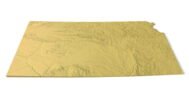

Kansas Topographic Map STL – 3D Terrain Model for 3D Printing & CNC
Original price was: $21.00.$15.00Current price is: $15.00.
![]()
- File size: 135 MB
- Model size: 154.7014 mm x 200 mm x 3 mm
- Projection: Mercator
- Scaling factor: X — 1; Y — 1; Z — 3
- Polygons: 2 831 910
- Vertices: 1 415 957
- Geometry: Polygonal Tris only
- Base: Closed
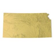
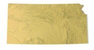
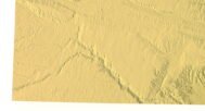
Kansas Topographic Map STL – High-Detail 3D Terrain Model
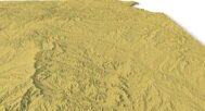
Kansas Topographic Map STL is a precise 3D terrain model based on elevation data, created for 3D printing, CNC carving, and laser engraving. The model accurately represents the relief and landscape of the state of Kansas, including plains, river valleys, and subtle elevation changes characteristic of the region.
Delivered in STL format, this Kansas terrain model is optimized for FDM and SLA 3D printers, as well as CNC routers and milling machines. Clean polygonal geometry and correct vertical scaling ensure realistic depth and smooth surface transitions in physical relief maps.
Key Features of the Kansas Terrain STL Model
- High-detail Kansas topographic map STL
- Accurate digital elevation model (DEM)
- Suitable for 3D printing (FDM / SLA)
- Compatible with CNC carving and milling
- Ready for laser engraving
- Mercator projection for consistent proportions
- Triangle-only polygonal mesh
- Open or closed base option
Applications of the Kansas 3D Topographic Map
This Kansas 3D terrain model is suitable for a wide range of uses:
- Raised topographic relief maps
- CNC-carved wooden or metal terrain models
- Educational geography and earth science projects
- Landscape and terrain visualization
- Museum exhibits and presentation models
- Decorative wall maps and custom map installations
Whether you are producing a 3D printed Kansas map, a CNC terrain model, or a laser-engraved relief, this STL file provides reliable accuracy and professional-quality results.