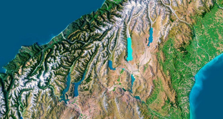
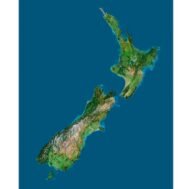
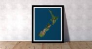
info@shustrik-maps.com

Contact me


    Free conversion to OBJ/FBX/STL/C4D
    • Services
    • About
    • FAQ
    • Site Map
    • How to buy?
    info@shustrik-maps.com

    Contact me


      Logo shustrik maps
      • 3D MODELSOBJ/FBX/C4D
        • Solar System

          3D MODELS OF SOLAR SYSTEM OBJECTS

          Planets (11)

          11 products

          Space objects (3)

          3 products
        • World

          World (6)

          6 products

          North Pole (1)

          1 product

          South Pole (1)

          1 product

          Fantasy (2)

          2 products
        • Continents

          North America (2)

          2 products

          South America (2)

          2 products

          Europe (2)

          2 products

          Asia (1)

          1 product

          Africa (2)

          2 products

          Oceania (3)

          3 products

          Antarctica (1)

          1 product
        • Peninsulas

          Peninsulas (1)

          1 product
        • Islands

          Islands (13)

          13 products
        • Countries

          All countries →

          3D MODELS OF THE COUNTRIES

          A | B | C | D | E | 

          F | G | H | I | J | 

          K | L | M | N | O | 

          P | Q | R | S | T | 

          U | V | W | Y | Z | 

          3D MODELS OF COUNTRIES BY CONTINENT

          NORTH AMERICA

          • Northern America
          • Central America
          • Caribbean

          SOUTH AMERICA

          EUROPE

          • Western Europe
          • Northern Europe
          • Southern Europe
          • Eastern Europe

          AFRICA

          • Eastern Africa
          • Middle Africa
          • Northern Africa
          • Southern Africa
          • Western Africa

          ASIA

          • Central Asia
          • Eastern Asia
          • Southeast Asia
          • Southern Asia
          • Western Asia
        • States of America

          All states →

          UNITED STATES 3D MODELS

          Alabama

          • C4D/OBJ/BLEND 
          • STL
          • Satellite Map

          Alaska

          • STL


          Arizona

          • C4D/OBJ/BLEND 
          • STL
          • Satellite Map

          Arkansas

          • C4D/OBJ/BLEND 
          • STL
          • Satellite Map

          California

          • Tex 1: C4D/OBJ
          • Tex 2: C4D/OBJ
          • STL
          • Satellite Map

          Colorado

          • C4D/OBJ/BLEND
          • STL
          • Satellite Map

          Connecticut

          • STL
          • Satellite Map

          Delaware

          • STL
          • Satellite Map

          Florida

          • C4D/OBJ/BLEND
          • STL
          • Satellite Map

          Georgia

          • STL
          • Satellite Map

          Hawaii

          • C4D/OBJ/BLEND
          • STL


          Idaho

          • C4D/OBJ/BLEND
          • STL
          • Satellite Map

          Illinois

          • STL
          • Satellite Map

          Indiana

          • C4D/OBJ/BLEND
          • STL
          • Satellite Map

          Iowa

          • C4D/OBJ/BLEND
          • STL
          • Satellite Map

          Kansas

          • C4D/OBJ/BLEND
          • STL
          • Satellite Map

          Kentucky

          • STL
          • Satellite Map

          Louisiana

          • STL
          • Satellite Map

          Maine

          • STL
          • Satellite Map

          Maryland

          • STL
          • Satellite Map

          Massachusetts

          • STL
          • Satellite Map

          Michigan

          • STL

          Minnesota

          • STL


          Mississippi

          • STL

          Missouri

          • STL

          Montana

          • Tex 1: C4D/OBJ
          • Tex 1: C4D/OBJ
          • STL

          Nebraska

          • C4D/OBJ/BLEND
          • STL


          Nevada

          • C4D/OBJ/BLEND
          • STL


          New Hampshire

          • STL


          New Jersey

          • STL

          New Mexico

          • C4D/OBJ/BLEND
          • STL

          New York

          • STL


          North Carolina

          • STL

          North Dakota

          • C4D/OBJ/BLEND
          • STL

          Ohio

          • STL


          Oklahoma

          • STL

          Oregon

          • C4D/OBJ/BLEND
          • STL

          Pennsylvania

          • STL


          Rhode Island

          • STL

          South Carolina

          • STL

          South Dakota

          • C4D/OBJ/BLEND
          • STL

          Tennessee

          • STL


          Texas

          • C4D/OBJ/BLEND
          • STL

          Utah

          • C4D/OBJ/BLEND
          • STL


          Vermont

          • STL


          Virginia

          • STL

          Washington

          • C4D/OBJ/BLEND
          • STL

          West Virginia

          • STL


          Wisconsin

          • STL

          Wyoming

          • C4D/OBJ/BLEND
          • STL
        • Canadian Provinces

          CANADIAN PROVINCES 3D MODELS

          Alberta

          British Columbia

          Manitoba

          New Brunswick

          Newfoundland

          Nova Scotia

          Ontario

          Prince Edward

          Quebec

          Saskatchewan

          CANADIAN TERRITORIES 3D MODELS

          Northwest Territories

          Nunavut

          Yukon

        • Parks & Canyons

          3D MODELS OF NATIONAL PARKS AND CANYONS

          Canyons (2)

          2 products
        • Other

          ART (5)

          5 products
      • 3D PRINT/CNC MODELSSTL
        • Planets
        • Satellites
        • Continents
        • Countries
        • Islands
        • States of America
        • Fantasy
        • Other
      • MAPSTIF/PSD/SVG
        • Satellite Maps
        • Night Satellite Map
        • Heightmaps/Raster DEM
        • Relief Maps
        • 3D Maps
        • Historical Maps
        • Outline Maps
      • FREE
      • SERVICES
      • A-Z
      Search
      0 items / $0.00
      Menu
      3D Models and 3D Maps
      0 items / $0.00
      New Zealand map
      Topographic map New Zealand
      New Zealand terrain
      Digital elevation model of New Zealand, providing accurate elevation data for geographic information systems and design projects.
      A high-quality 3D terrain map of New Zealand, showcasing its topography for landscape analysis and geospatial applications.
      A 3D map of New Zealand showing detailed terrain features and elevation data, ideal for topographical visualization.
      New Zealand 3D map
      Click to enlarge
      New Zealand map
      Topographic map New Zealand
      New Zealand terrain
      Digital elevation model of New Zealand, providing accurate elevation data for geographic information systems and design projects.
      A high-quality 3D terrain map of New Zealand, showcasing its topography for landscape analysis and geospatial applications.
      A 3D map of New Zealand showing detailed terrain features and elevation data, ideal for topographical visualization.
      New Zealand 3D map
      Home MAPS 3D Maps New Zealand 3D Map
      A detailed 3D topographic map of Australia showcasing its diverse terrain, including mountains, valleys, and deserts.
      Australia 3D Map $32.00
      Back to products
      Earth 3D model
      3D Model of Planet Earth $35.00

      New Zealand 3D Map

      $32.00

      3D Map of New Zealand: Detailed Terrain Mapping and Visualization

      • Linear size: 67 x 84 cm
      • Pixel resolution: 79 MPx (7968 px x 10 000 px)
      • File size: ~600 MB
      • Color Depth: 16 Bit/channel
      • Color model: RGB
      • Print resolution: 300 DPI
      • Projection: Mercator

      We accept VISA, Mastercard, ApplePay, GooglePay and other payment methods

      — OR —

      You can also purchase this product using MasterCard/Visa on
      RenderHub →  and 3Dexport →.

      SKU: SH_7568 Category: 3D Maps Tags: Countries, Mercator, Oceania, TIF
      Share:
      • Description
      Description

      Discover the stunning landscapes of New Zealand with our 3D map, offering an immersive experience for terrain mapping, geospatial representation, and educational or design projects. This digital elevation model brings New Zealand’s topography to life, making it ideal for various applications including interactive cartography and landscape analysis.

      Key Features of Our 3D Map of New Zealand

      • Topographical Visualization: The model provides detailed topographical visualization of New Zealand’s diverse terrain, including mountains, plains, and coastal areas.
      • Versatile Applications: Perfect for 3D modeling, educational projects, or design work. Use it in geographic information system (GIS) applications or virtual reality landscape presentations.

      Accurate Digital Elevation Model for Geospatial Analysis

      This 3D map of New Zealand offers precise elevation data, making it an essential tool for landscape analysis and geospatial representation. Whether you’re studying New Zealand’s terrain or using it for design purposes, this model guarantees accurate topographical detail and clarity.

      Ideal for Interactive Cartography and Virtual Reality Projects

      The model is designed for interactive cartography and can be integrated into virtual reality landscape projects, providing a dynamic way to explore and understand New Zealand’s geography.

      Why Choose Our 3D Map of New Zealand?

      • Highly Detailed: The map delivers precise digital elevation and detailed terrain features for accurate analysis.
      • Multi-Purpose: Suitable for design, educational, and GIS applications, offering flexibility across various industries.
      • Customizable: Easily integrated into presentations, virtual environments, or physical models for customized projects.

      Explore the richness of New Zealand’s landscape with our 3D map, offering both beauty and functionality for any project. Download now and bring New Zealand’s topography to life!

      New Zealand 3D Map is a digital image designed for printing on a flat surface. Rendered with a high level of detail, it allows you to print images on professional photo paper, metal (HD Metal Print), acrylic, as well as on walls using special equipment.

      New Zealand 3D map

      Ideal for Every Explorer: Wherever Your Passion Lies

      Whether you’re planning your next New Zealand adventure, teaching geography to curious minds, or adorning your living space with a touch of New Zealand’s charm, our 3D map is your gateway to the country’s wonders.

      For the Classroom: Inspire Curiosity, Foster Knowledge

      Transform your classroom into an interactive hub of learning. Enhance geography lessons, captivate young minds, and instill a love for exploration with our 3D map.

      For Travel Enthusiasts: Plan Your Next Adventure

      Chart your course across New Zealand’s diverse landscapes. Plan your travels with precision, exploring every corner of this breathtakingly beautiful nation before you even set foot outside your door.

      For Home Decor: Infuse Your Space with Kiwi Charm

      Add a touch of elegance to your living space. Whether it’s your living room, study, or office, let New Zealand’s beauty grace your walls, sparking conversations and igniting imaginations.

      Experience New Zealand Like Never Before: Your Passport to Kiwi Beauty

      Indulge your senses, expand your knowledge, and let your imagination roam freely across New Zealand’s stunning landscapes. Purchase your 3D map now and let the adventure begin.

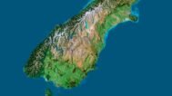
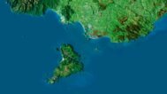
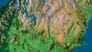
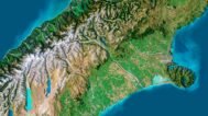
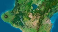
      New Zealand 3D Map at 100% zoom (Click to zoom in)

      New Zealand relief map

      Leave a request if you need a New Zealand 3D Map in other sizes, resolutions or projections.

      New Zealand 3D Model Terrain Map
      3D map New Zealand
      New Zealand STL model
      New Zealand Satellite Map

      Related products

      High-detail 3D terrain of Andorra with elevation data
      3D front view of Andorra terrain STL model

      Andorra Topographic Map – 3D Terrain Model for Printing & CNC Carving

      $15.00
      Add to cart
      Full topographic STL model of Armenia with elevation features
      Detailed 3D terrain of Armenia with contour line structure

      Armenia Topographic Map – 3D Terrain Model for Printing & CNC Carving

      $15.00
      Add to cart
      STL file of France’s topography for CNC and 3D printers
      France’s DEM-based 3D terrain model in STL

      France Topographic Map – 3D Model for 3D Printing & CNC Carving

      $15.00
      Add to cart
      3D terrain model of Japan in STL format, front view
      STL file of Japan map for CNC and 3D printing

      Japan Topographic Map – 3D Model for 3D Printing & CNC Carving

      $15.00
      Add to cart
      3D terrain model of Kosovo in STL format, front view
      STL file of Kosovo map for CNC and 3D printing

      Kosovo Topographic Map – 3D Model for 3D Printing & CNC Carving

      $15.00
      Add to cart
      -19%
      Kuwait STL model
      Kuwait 3D model

      Kuwait STL model

      $21.00 Original price was: $21.00.$17.00Current price is: $17.00.
      Add to cart
      Italy relief
      Topographic map Italy

      Relief map of Italy

      $15.00
      Add to cart
      Relief map of Japan
      Japan maps 3d

      Relief map of Japan

      Read more
      Relief map of Slovakia
      mapa 3d Slovakia

      Relief map of Slovakia

      Read more
      Relief map of Taiwan
      mapa 3d Taiwan

      Relief map of Taiwan

      Read more
        INFO
        • About
        • Explore Our Terrain Services
        • Support
        • Shipping and delivery policy
        • Refund and Returns Policy
        • Privacy Policy
        • in**@***********ps.com
        • Blog
        How to buy
        • TERRAIN 3D MODELS FREE
        • Purchase with Crypto/PayPal/VISA
        • Buy on Cults3D.com
        • Buy on CGtrader.com
        • Buy on RenderHub.com
        • Buy on 3DExport.com
        • Discounts
        Buy 3D models
        • Planets
        • World
        • Continents
        • Peninsulas
        • Islands
        • Countries
        • States of America
        • Canadian Provinces
        • Canyons
        • Cities
        • Fantasy
        • Minecraft
        Buy 3D models for CNC
        • Planets
        • Continents
        • Islands
        • Countries
        • States of America

        DEM DSM DTM FBX OBJ STL

        SHUSTRIK-MAPS 2025
        • 3D MODELS
          • Solar System
          • World
          • Continents
          • Peninsulas
          • Islands
          • Countries
          • States of America
          • Canadian Provinces
          • Canyons
          • Buildings
          • Fantasy
          • ART
        • 3D PRINT/CNC MODELS
          • Planets
          • Satellites
          • Continents
          • Countries
          • Islands
          • States of America
          • Fantasy
          • Other
        • MAPS
        • A-Z
        • FREE
        • About
        • FAQ
        • How to buy?
        • Site Map HTML
        • Explore Our Terrain Services
        Shopping cart
        Close
        Start typing to see products you are looking for.
        Your amount to pay has been updated
        The previous conversion quote has expired. Here is your new quote:
        Total
        $
        You Pay
        Back to checkout
        Place Order