Blog
DEM Resolution
DEM spatial resolution – what does it mean for 3D designers?
Digital Elevation Models (DEMs) play a key role in creating accurate and detailed 3D models of the earth’s surface. It is used in a variety of applications including urban planning, environmental assessment, flood modeling, and virtual reality applications. 3D models are also used by hobbyists to create physical models on 3D printers and CNC machines. One of the most important aspects that significantly affect the quality and accuracy of such models is their spatial resolution. In it we will consider the concept of spatial resolution of DEM and its importance for developers of 3D models.
WHAT IS SPATIAL RESOLUTION?
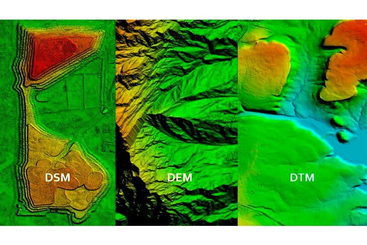
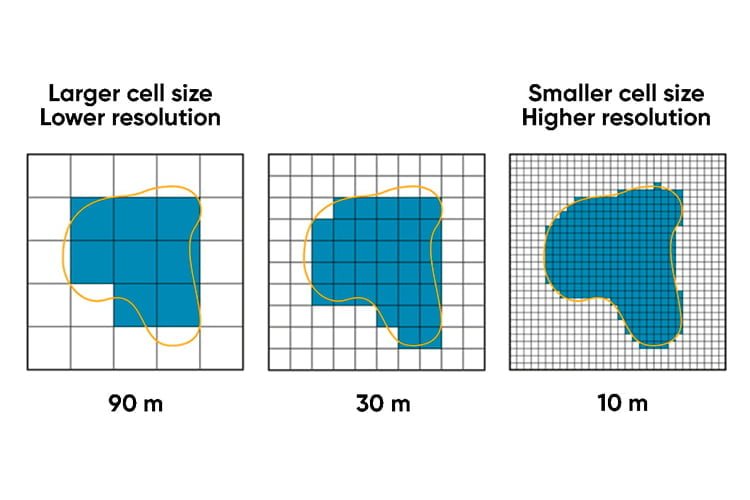
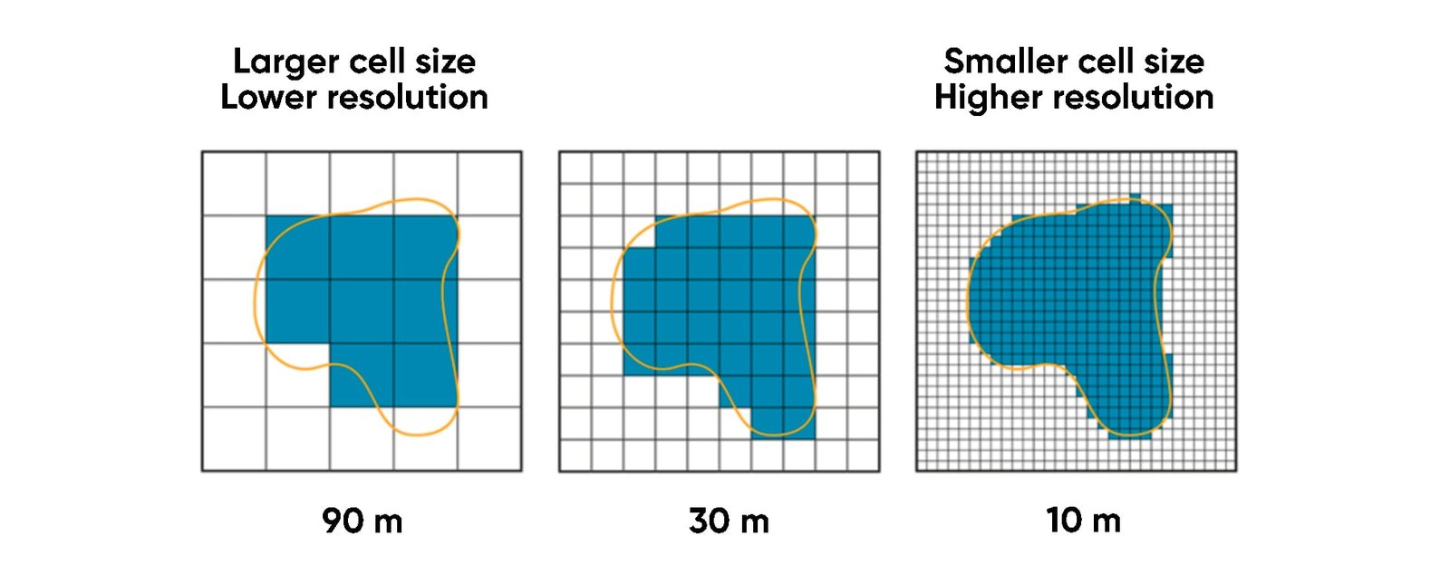
DEM, DTM or DSM data is used to represent the physical surface of the earth. DEM can be used in various 3D packages such as Blender, Cinema 4D, 3D Max, World Machine to create 3D terrain as a uniform grid of square or triangular polygons. Spatial resolution refers to the land area represented by a single grid cell. Thus, a spatial resolution of 10 meters means that one 3D model grid cell represents a 10 x 10 meter area of land. Low (or coarse) resolution and high (or high) resolution are relative terms. “Higher” resolution implies relatively greater preservation of land features, while a “lower” resolution dataset tends to smooth out topographic details. The most common DEM resolutions range from 90 m to 1 meter.
WHAT SPATIAL RESOLUTION SHOULD YOU CHOOSE?
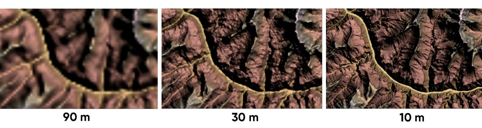
The higher the resolution of the DEM, the greater the preservation of topographic features of the terrain. It provides better definition of floodplains, small streams, roads and other narrow watercourses, which can significantly affect results. While the availability of high-resolution terrain data is increasing, it is still not available everywhere. It is often limited to countries and regions with high concentrations of population and/or economic development.
Almost the entire world is available for free at 30 m resolution. Paid services offer DEM at 10 and 1 m resolution. But the cost of such data is very high.
It should also be realized that the more complex the models (i.e. higher the spatial resolution), the higher the requirements for computing power, processing time, file size, and data storage. It is reflected in the increased cost of the final 3D models.
Developers of 3D models strive to use a level of resolution that is reasonable for the task at hand.
For example, if you need to get a physical model of a 20*20 cm terrain section on an FDM printer, there is no need to look for a highly detailed model. The FDM printer will not be able to print all the fine details.
If you need to make a few general plan renders, there is no need to pay for high resolution. If, however, the camera in the scene will be as close to the terrain as possible, then you need high resolution, but on a small area.
If you want to make a physical model on a 3*2 meter CNC machine and it will be finished with a 0.5mm diameter mill, then you should look for a higher quality model.
If you have an industrial SLA (DLP) printer, then you should also look for a model of maximum quality.
A detailed description of your task or idea will help developers to provide you with a quality model at a reasonable cost.
ACHIEVING THE RIGHT BALANCE
Ultimately, the most informed decisions can be made by those who have access to the right expertise. Talk to us about the range of data we provide, how it can be used, the individual counseling options we offer, and choosing the best option for you.