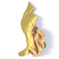
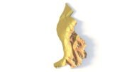
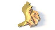
Liechtenstein Topographic Map STL – 3D Terrain Model for 3D Printing & CNC
$15.00
![]()
• Format: STL
• File size: 158 MB
• Polygons: 3 320 576
• Vertices: 1 660 290
• Geometry: Polygonal Tris only
• Model size: 183 mm x 365 mm x 27.5 mm
• Projection: Mercator
• Scaling factor X:Y:Z: 1:1:1
• Base: Closed
Liechtenstein Topographic Map STL – High-Detail Alpine 3D Terrain Model
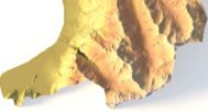
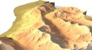
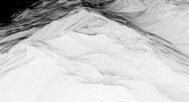
Liechtenstein Topographic Map STL is a high-resolution 3D terrain model created from an accurate digital elevation model (DEM) and optimized for 3D printing, CNC carving, and laser engraving. The model precisely represents the Alpine landscape of Liechtenstein, including steep mountain slopes, valleys, and the Rhine Valley, making it ideal for professional, educational, and creative projects.
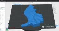
Delivered in STL format, this Liechtenstein terrain model is fully compatible with FDM and SLA 3D printers, as well as CNC routers and milling machines. Clean polygonal geometry and carefully tuned vertical scaling ensure realistic elevation depth and smooth surface transitions in physical relief maps made from plastic, wood, or metal.
This STL file is fully compatible with FDM and SLA 3D printers, as well as CNC routers. You can 3D print a realistic map of Liechtenstein in plastic or carve it from wood or metal. It’s ideal for educational models, souvenir production, landscape projects, and terrain visualization.
This topographic model can serve as a striking element in a design studio, classroom, or architectural presentation. With precise elevation modeling and high visual fidelity, it inspires creative use and brings real-world landscapes to life.


Why choose this model?
✔ Realistic Topography Based on Geospatial Data – Built from a digital elevation model (DEM) for accuracy.
✔ Ready for 3D Printing & CNC Machining – Clean STL file optimized for PLA, resin, wood, aluminum, and more.
✔ Designed for Education, Design & Creativity – Perfect for geography classes, architecture layouts, art pieces, and souvenirs.
Sample Use Cases:
3D print a raised-relief map of Liechtenstein for geography lessons
CNC carve Liechtenstein’s Alpine terrain into wood or metal
Create terrain layouts for architectural planning
Produce Liechtenstein-themed wall art or display models
Design unique geographic gifts and jewelry
How do I change the parameters of the STL model of Liechtenstein?
You can easily resize the model in any program that allows you to import STL files.
In addition to changing the scale in width, length, and height, you can add a higher base. You can also use anti-aliasing tools, add bulk text, reduce the number of polygons, etc.
FAQ
The description includes scaling factors for each axis. For example, if you see X – 0.001, Y – 0.001, Z – 0.003, this means the height is three times greater than the width and length. We scale height this way to emphasize the relief.
If you need uniform proportions, let us know—we’ll prepare a custom model upon request.
Send us your required specifications, and we’ll adapt the model accordingly.
Yes, we check every model for integrity and errors.
Yes. For better surface quality, we recommend printing it vertically.
Larger models require more polygons to preserve relief detail. Provide your desired dimensions, and we’ll prepare:
A single optimized model or
A segmented version with high resolution.
Yes, but polygon reduction may be necessary. Submit a request with your project’s dimensions for a tailored solution.