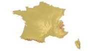

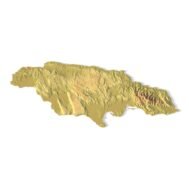
France Topographic Map – 3D Model for 3D Printing & CNC Carving
$15.00
High-polygon 3D model of France in STL format
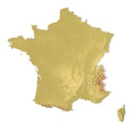
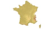
![]()
- Format: STL
- File size: 118 MB
- Polygons: 2 488 218
- Vertices: 1 244 182
- Geometry: Polygonal Tris only
- Model size: 220 mm x 211 mm x 1.9 mm
- Projection: Mercator
- Base: Closed
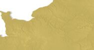
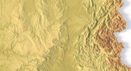
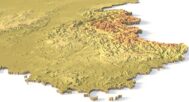
The France Topographic Map is a high-resolution 3D terrain model based on an accurate digital elevation model (DEM). It faithfully captures France’s diverse landscapes—from the Alps and Pyrenees mountains to the Loire Valley, French Riviera coastlines, and Paris Basin—making it ideal for designers, educators, cartographers, and geography enthusiasts.
This STL file is fully compatible with FDM and SLA 3D printers, as well as CNC routers. 3D print a realistic map of France in plastic or carve it from wood, metal, or resin. Perfect for educational models, souvenir production, architectural projects, and terrain visualization.
Use this topographic model as a striking centerpiece in classrooms, design studios, or architectural presentations. With precise elevation data and smooth mesh optimization, it ensures professional-quality prints and carvings that bring France’s geography to life.


Why choose this model:
✔ Geospatial Accuracy
Built from real DEM data for true-to-life elevation details, ideal for GIS projects or geography lessons.
✔ 3D Printing & CNC Ready
Optimized STL file works flawlessly with PLA, resin, wood, aluminum, and more. Scalable for any project size.
✔ Versatile Applications
Great for education, art, design, souvenirs, and terrain analysis—limited only by your creativity!
Sample Use Cases:
3D print a raised-relief map of France for school geography classes
CNC carve the Mont Blanc massif into wood for a decorative wall piece
Create terrain-aware layouts for urban planning or game design
Produce Eiffel Tower-themed topographic art or custom gifts
Design miniature French landscapes for tabletop games or dioramas