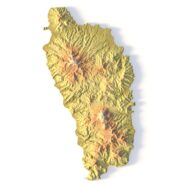
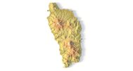
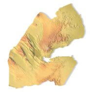
Dominica Topographic Map – 3D Model for 3D Printing & CNC Carving
$15.00
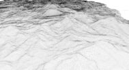
High-polygon 3D model of Dominica in STL format
![]()
- File size: 54 MB
- Model size: 107 mm x 200 mm x 9.9 mm
- Projection: Mercator
- Scaling factor: X — 0,001; Y — 0,001; Z — 0,0012
- Polygons: 1 133 110
- Vertices: 566 557
- Geometry: Polygonal Tris only
- Base: Closed
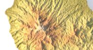
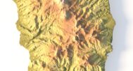
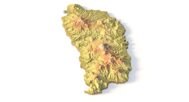
The Dominica Topographic Map is a high-resolution 3D terrain model based on an accurate digital elevation model (DEM). It faithfully captures Dominica’s dramatic volcanic peaks, deep valleys, rainforest-covered slopes, and rugged coastline, making it an exceptional choice for designers, educators, cartographers, and geography enthusiasts.
This STL file is fully compatible with FDM and SLA 3D printers, as well as CNC routers. You can 3D print a realistic map of Dominica in plastic or carve it from wood, resin, or metal. Ideal for educational models, souvenir production, landscape projects, and immersive terrain visualization.
This model serves as a striking centerpiece in design studios, classrooms, or eco-tourism displays. With precise elevation detailing and high visual fidelity, it inspires creativity and brings Dominica’s “Nature Island” landscapes to life. Every ridge, river, and volcanic crater is meticulously modeled for professional-quality prints.


Why choose this model?
✔ Authentic Topography from Geospatial Data
Built from real DEM data for geographic accuracy—perfect for 3D terrain analysis, hiking trail planning, or environmental studies.
✔ Optimized for 3D Printing & CNC Machining
Clean, manifold STL file works flawlessly with PLA, resin, wood, or metal. Scalable for tabletop displays or large-format carvings.
✔ Versatile for Education & Creative Projects
Great for geography lessons, travel agency displays, eco-resort decor, or handmade Caribbean-themed souvenirs.
Sample Use Cases:
3D print a raised-relief map of Dominica for school geography projects
CNC carve Morne Trois Pitons’ volcanic peaks into wood for a travel agency display
Design elevation-accurate terrain for sustainable architecture planning
Create Dominica-themed wall art or eco-tourism souvenirs
Craft unique jewelry featuring the island’s iconic topography