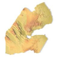

Djibouti Topographic Map – 3D Model for 3D Printing & CNC Carving
$15.00
High-polygon 3D model of Djibouti in STL format
![]()
- File size: 118 MB
- Model size: 183 mm х 202 mm х 3.5 mm
- Projection: Mercator
- Scaling factor: X — 0,001; Y — 0,001; Z — 0,0025
- Polygons: 2 478 110
- Vertices: 1 239 078
- Geometry: Polygonal Tris only
- Base: Closed
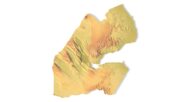
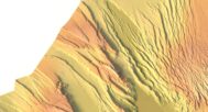
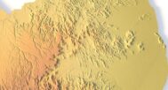
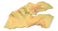
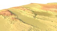
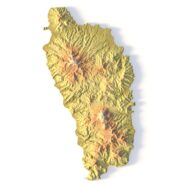
The Djibouti Topographic Map is a high-resolution 3D terrain model based on an accurate digital elevation model (DEM). It faithfully captures Djibouti’s striking landscapes, including the Ardoukoba Volcano, Lake Assal (Africa’s lowest point), the Goda Mountains, and the coastal plains of the Gulf of Aden. This makes it an exceptional choice for designers, educators, cartographers, and geography enthusiasts.
This STL file is fully compatible with FDM and SLA 3D printers, as well as CNC routers. You can 3D print a realistic map of Djibouti in plastic or carve it from wood or metal. Ideal for educational models, souvenir production, architectural projects, and terrain visualization.
This topographic model serves as a striking element in design studios, classrooms, or architectural presentations. With precise elevation modeling and high visual fidelity, it inspires creative applications and brings Djibouti’s rugged landscapes to life. Every volcanic crater, salt flat, and mountain ridge is carefully modeled for professional results.


Why Choose This Model?
✔ Realistic Topography Based on Geospatial Data
Built from a digital elevation model (DEM) for scientific accuracy. Perfect for 3D terrain visualization and mapping projects.
✔ Ready for 3D Printing & CNC Machining
Optimized STL file works with PLA, resin, wood, aluminum, and more. Scalable for different project sizes.
✔ Designed for Education, Design & Creativity
Use in geography classes, architectural layouts, art installations, or custom souvenirs.
Sample Use Cases:
3D print a raised-relief map of Djibouti for geography or geology lessons
CNC carve Lake Assal’s salt flats into wood or metal for educational displays
Create terrain-aware models for architectural or environmental planning
Produce Djibouti-themed wall art or display models
Design unique gifts or geographic jewelry inspired by Djibouti’s landscapes