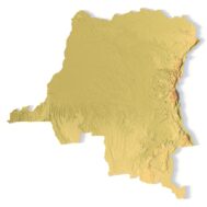
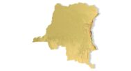


DR Congo Topographic Map – 3D Model for 3D Printing & CNC Carving
$15.00
High-polygon 3D model of Democratic Republic of Congo in STL format
![]()
- File size: 219 MB
- Model size: 220 mm х 217 mm х 4 mm
- Projection: Mercator
- Scaling factor: X — 0,001; Y — 0,001; Z — 0,008
- Polygons: 4 602 312
- Vertices: 2 301 122
- Geometry: Polygonal Tris only
- Base: Closed
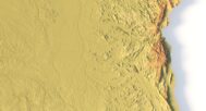
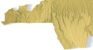
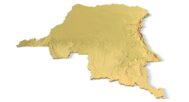
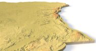
The Democratic Republic of Congo (DRC) Topographic Map is a high-resolution 3D terrain model based on an accurate digital elevation model (DEM). It faithfully represents the Congo Basin rainforests, highland plateaus, volcanic mountains (Virunga Range), and the Congo River network, making it an invaluable tool for geographers, educators, researchers, and designers.
This STL file is fully compatible with FDM/SLA 3D printers and CNC routers, allowing you to print a realistic map in plastic, resin, wood, or metal. Ideal for:
Educational terrain models (geography, geology, environmental studies)
Souvenir and cultural gift production
Architectural and landscape planning
Scientific visualization and research projects
With precise elevation data and optimized geometry, this model ensures smooth 3D printing and CNC machining at various scales. The intricate details highlight the DRC’s diverse landscapes, from dense jungles to rugged highlands.


Why Choose This Model?
✔ Accurate Geospatial Data – Based on satellite DEM for real-world terrain fidelity.
✔ Print & Carve Ready – Clean STL file works with PLA, resin, wood, metal.
✔ Multi-Purpose Use – Great for education, design, research, and decor.
Sample Use Cases:
3D print a raised-relief map of the DRC for classroom geography lessons.
CNC carve the Congo River Basin into wood for museum displays.
Create topographic models for environmental and hydrological studies.
Design DRC-themed wall art, souvenirs, or jewelry.
Use in architectural projects requiring terrain-aware planning.