

Armenia Topographic Map – 3D Terrain Model for Printing & CNC Carving
$15.00
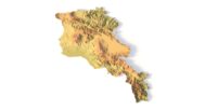
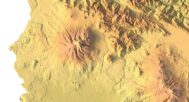
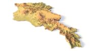
Accurate and Printable 3D STL Map of Armenia
![]()
- File size: 363 MB
- Model size: 354 mm x 360 mm x 14 mm
- Projection: Mercator
- Scaling factor: X — 0,001; Y — 0,001; Z — 0,003
- Polygons: 7 612 888
- Vertices: 3 806 444
- Geometry: Polygonal Tris only
- Base: Closed
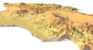
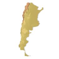
The Armenia Topographic Map is a precision-crafted 3D STL model derived from high-resolution digital elevation data, designed for accurate terrain modeling, elevation mapping, and physical reproduction via 3D printing or CNC carving.
This model suitable for FDM and SLA 3D printers, as well as CNC routers, and serves professionals, educators, and creatives seeking a physical replica of Armenia’s landscape.
Applications of the Armenia Topographic STL Model
3D Printing: Create physical models of Armenia’s terrain using FDM or SLA 3D printers, showcasing the country’s elevation data and unique landscapes, from the Armenian Highlands to the Ararat Valley.
CNC Machining: Perfect for crafting detailed relief maps from wood or metal, this model offers precise contours for professional design, geographic analysis, and artistic projects.
Laser Engraving: Use this model for high-precision laser engraving on metals or acrylic, capturing the intricate topography of Armenia, including its mountains, valleys, and volcanic formations.
Detailed Terrain Representation for Educational and Professional Use
This Armenia topographic map provides a comprehensive digital elevation model (DEM), offering accurate elevation data for researchers, educators, and designers. From Mount Aragats to the Debed Canyon, this model accurately reflects Armenia’s diverse geography, making it an essential tool for landform analysis, GIS studies, and 3D terrain visualization.
Bring Armenia’s Landscapes to Life!
Download our Armenia Topographic Map STL Model today and create stunning, customizable 3D representations of Armenia’s breathtaking terrain.


Why Choose Our Armenia Topographic Map STL Model?
✅ High-Precision Topography – Detailed terrain representation with accurate elevation data for educational, scientific, and creative projects.
✅ Multi-Purpose Use – Ideal for 3D printing, CNC machining, and laser engraving, suitable for both professionals and hobbyists.
✅ Fully Customizable – Modify the STL model to fit your project needs, whether for geographic research, architectural planning, or artistic displays.
Sample Applications
Print a classroom or museum-ready Armenia terrain map
Carve a large-scale relief in wood using CNC
Model regional elevation differences for visual presentation
Use in architectural site context modeling
Create Armenia-themed terrain artwork
FAQ
The description includes scaling factors for each axis. For example, if you see X – 0.001, Y – 0.001, Z – 0.003, this means the height is three times greater than the width and length. We scale height this way to emphasize the relief.
If you need uniform proportions, let us know—we’ll prepare a custom model upon request.
Send us your required specifications, and we’ll adapt the model accordingly.
Yes, we check every model for integrity and errors.
Yes. For better surface quality, we recommend printing it vertically.
Larger models require more polygons to preserve relief detail. Provide your desired dimensions, and we’ll prepare:
A single optimized model or
A segmented version with high resolution.
Yes, but polygon reduction may be necessary. Submit a request with your project’s dimensions for a tailored solution.