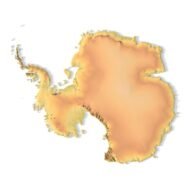
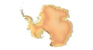
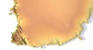
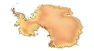
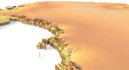
info@shustrik-maps.com

Contact me


    Free conversion to OBJ/FBX/STL/C4D
    • Services
    • About
    • FAQ
    • Site Map
    • How to buy?
    info@shustrik-maps.com

    Contact me


      Logo shustrik maps
      • 3D MODELSOBJ/FBX/C4D
        • Solar System

          3D MODELS OF SOLAR SYSTEM OBJECTS

          Planets (11)

          11 products

          Satellites (1)

          1 product

          Space objects (3)

          3 products
        • World

          World (8)

          8 products

          North Pole (1)

          1 product

          South Pole (1)

          1 product

          Fantasy (2)

          2 products
        • Continents

          North America (2)

          2 products

          South America (2)

          2 products

          Europe (2)

          2 products

          Asia (1)

          1 product

          Africa (2)

          2 products

          Oceania (3)

          3 products

          Antarctica (1)

          1 product
        • Peninsulas

          Peninsulas (1)

          1 product
        • Islands

          Islands (13)

          13 products
        • Countries

          All countries →

          3D MODELS OF THE COUNTRIES

          A | B | C | D | E | 

          F | G | H | I | J | 

          K | L | M | N | O | 

          P | Q | R | S | T | 

          U | V | W | Y | Z | 

          3D MODELS OF COUNTRIES BY CONTINENT

          NORTH AMERICA

          • Northern America
          • Central America
          • Caribbean

          SOUTH AMERICA

          EUROPE

          • Western Europe
          • Northern Europe
          • Southern Europe
          • Eastern Europe

          AFRICA

          • Eastern Africa
          • Middle Africa
          • Northern Africa
          • Southern Africa
          • Western Africa

          ASIA

          • Central Asia
          • Eastern Asia
          • Southeast Asia
          • Southern Asia
          • Western Asia
        • States of America

          All states →

          UNITED STATES 3D MODELS

          Alabama

          • C4D/OBJ/BLEND 
          • STL
          • Satellite Map

          Alaska

          • STL


          Arizona

          • C4D/OBJ/BLEND 
          • STL
          • Satellite Map

          Arkansas

          • C4D/OBJ/BLEND 
          • STL
          • Satellite Map

          California

          • Tex 1: C4D/OBJ
          • Tex 2: C4D/OBJ
          • STL
          • Satellite Map

          Colorado

          • C4D/OBJ/BLEND
          • STL
          • Satellite Map

          Connecticut

          • STL
          • Satellite Map

          Delaware

          • STL
          • Satellite Map

          Florida

          • C4D/OBJ/BLEND
          • STL
          • Satellite Map

          Georgia

          • STL
          • Satellite Map

          Hawaii

          • C4D/OBJ/BLEND
          • STL


          Idaho

          • C4D/OBJ/BLEND
          • STL
          • Satellite Map

          Illinois

          • STL
          • Satellite Map

          Indiana

          • C4D/OBJ/BLEND
          • STL
          • Satellite Map

          Iowa

          • C4D/OBJ/BLEND
          • STL
          • Satellite Map

          Kansas

          • C4D/OBJ/BLEND
          • STL
          • Satellite Map

          Kentucky

          • STL
          • Satellite Map

          Louisiana

          • STL
          • Satellite Map

          Maine

          • STL
          • Satellite Map

          Maryland

          • STL
          • Satellite Map

          Massachusetts

          • STL
          • Satellite Map

          Michigan

          • STL

          Minnesota

          • STL


          Mississippi

          • STL

          Missouri

          • STL

          Montana

          • Tex 1: C4D/OBJ
          • Tex 1: C4D/OBJ
          • STL

          Nebraska

          • C4D/OBJ/BLEND
          • STL


          Nevada

          • C4D/OBJ/BLEND
          • STL


          New Hampshire

          • STL


          New Jersey

          • STL

          New Mexico

          • C4D/OBJ/BLEND
          • STL

          New York

          • STL


          North Carolina

          • STL

          North Dakota

          • C4D/OBJ/BLEND
          • STL

          Ohio

          • STL


          Oklahoma

          • STL

          Oregon

          • C4D/OBJ/BLEND
          • STL

          Pennsylvania

          • STL


          Rhode Island

          • STL

          South Carolina

          • STL

          South Dakota

          • C4D/OBJ/BLEND
          • STL

          Tennessee

          • STL


          Texas

          • C4D/OBJ/BLEND
          • STL

          Utah

          • C4D/OBJ/BLEND
          • STL


          Vermont

          • STL


          Virginia

          • STL

          Washington

          • C4D/OBJ/BLEND
          • STL

          West Virginia

          • STL


          Wisconsin

          • STL

          Wyoming

          • C4D/OBJ/BLEND
          • STL
        • Canadian Provinces

          CANADIAN PROVINCES 3D MODELS

          Alberta

          British Columbia

          Manitoba

          New Brunswick

          Newfoundland

          Nova Scotia

          Ontario

          Prince Edward

          Quebec

          Saskatchewan

          CANADIAN TERRITORIES 3D MODELS

          Northwest Territories

          Nunavut

          Yukon

        • Parks & Canyons

          3D MODELS OF NATIONAL PARKS AND CANYONS

          Canyons (2)

          2 products
        • Other

          ART (6)

          6 products
      • 3D PRINT/CNC MODELSSTL
        • Planets
        • Satellites
        • Continents
        • Countries
        • Islands
        • States of America
        • Fantasy
        • Other
      • MAPSTIF/PSD/SVG
        • Satellite Maps
        • Night Satellite Map
        • Heightmaps/Raster DEM
        • Relief Maps
        • 3D Maps
        • Historical Maps
        • Outline Maps
      • FREE
      • SERVICES
      • A-Z
      Search
      0 items / $0.00
      Menu
      3D Models and 3D Maps
      0 items / $0.00
      Antarctica STL model
      Antarctica 3D model
      Antarctica buy 3d models
      A detailed 3D model of Antarctica showcasing its topographic features and landforms.
      A close-up view of an Antarctica STL model, perfect for 3D printing applications.
      Antarctica 3D Print model
      A 3D topographic model of Antarctica designed for terrain mapping and environmental studies.
      Click to enlarge
      Antarctica STL model
      Antarctica 3D model
      Antarctica buy 3d models
      A detailed 3D model of Antarctica showcasing its topographic features and landforms.
      A close-up view of an Antarctica STL model, perfect for 3D printing applications.
      Antarctica 3D Print model
      A 3D topographic model of Antarctica designed for terrain mapping and environmental studies.
      Home 3D PRINT/CNC MODELS Continents Antarctica 3D model
      Relief map of state of Washington
      Washington State 1883 Historical Relief Map
      Back to products
      Printable 3D terrain model of Australia with elevation detail
      Australia Topographic Map – 3D Model for 3D Printing & CNC Carving $15.00

      Antarctica 3D model

      $21.00

      3D Printable Model of Antarctica – Precision STL for Various Applications

      • File size: 454 MB
      • Model size: 533.7 mm x 477.45 mm x 6.173 mm
      • Resolution: 0.225 mm
      • Scaling factor: X — 0,0000001; Y — 0,0000001; Z — 0,0000012
      • Polygons: 9 540 458
      • Vertices: 4 770 628
      • Geometry: Polygonal Tris only
      • Base: Closed

      We accept VISA, Mastercard, ApplePay, GooglePay and other payment methods

      — OR —

      You can also purchase this product using MasterCard/Visa on
      RenderHub →  and 3Dexport →.

      SKU: SH_3619 Categories: 3D PRINT/CNC MODELS, Continents Tags: Continents, STL
      Share:
      • Description
      Description

      Our Antarctica 3D model provides a detailed and accurate topographic representation of the continent, ideal for a wide range of uses, from 3D printing to digital applications. This versatile model can help in visualizing polar regions and studying glaciology or even creating models for computer games.

      What can I use a 3D model in STL format for?

      Uses for the Antarctica 3D Model

      • 3D Printing Applications: Create physical models using plastic, photopolymer, or even wood and metal with CNC machines.
      • High-Resolution Relief: Achieve precise terrain mapping with 3D laser markers for stunning relief displays.
      • Master Forms Creation: Use the model to create master forms for product duplication, ideal for foam polystyrene or concrete casting.
      • Computer Graphics and Visualization: Import the model into 3D software to create realistic landscape modeling and visualizations.
      • Low-Poly Game Development: Use this model as a foundation for low-polygonal models in computer game design.

      Perfect for Scientists, Educators, and Designers

      This 3D model is ideal for those studying environmental changes and climate change in the polar regions, or anyone needing an accurate topographic map of Antarctica for scientific or creative purposes. From creating educational models to professional terrain mapping, this STL file offers a world of possibilities.

      Features of the Antarctica 3D Model

      • Highly detailed topography and landforms.
      • Supports various 3D printing methods.
      • Ready for use in 3D visualization projects and simulations.
      • Compatible with multiple CAD and game design programs.

      Enhance Your Projects with Realistic Antarctic Terrain

      This Antarctica 3D model is not only accurate but versatile, offering support for a wide range of disciplines, from scientific studies to game development.

      Wooden 3D map
      Terrain 3D print
      3D map of wood
      3D natural wood map
      3D metal map

        What is the resolution of the 3D model of Antarctica?

        With the development of technology, it is becoming possible to produce more and more precise relief models.

        For example, there are 3D printers that can print models with a layer height of 0.16 mm, 0.1 mm, 0.05 mm, or even less. These devices require high-quality models. But a higher-quality 3D model contains more polygons and has a larger file size. One of the challenges is to find a compromise between the file size of the STL model, which would be convenient to work with, and the desired quality of the finished product.

        The 3D model of Antarctica has a fairly large size and many polygons.

        Distance between neighboring points of one polygon in one plane is 0.225 mm for the specified size of the model. Therefore, such model is suitable for high-precision printing.

        How do I change the parameters of the STL model of Antarctica?

        You can easily resize the model in any program that allows you to import STL files.

        In addition to changing the scale in width, length, and height, you can add a higher base. You can also use anti-aliasing tools, add bulk text, reduce the number of polygons, etc.

        Leave a request if you need a model of Antarctica in other sizes, resolutions or projections.

        A 3D model of Antarctica showing detailed terrain and glaciation patterns, ideal for climate change research.
        Antarctica with ice 3D model
        North Pole 3D model

        Related products

        High-detail 3D terrain of Andorra with elevation data
        3D front view of Andorra terrain STL model

        Andorra Topographic Map – 3D Terrain Model for Printing & CNC Carving

        $15.00
        Add to cart
        Angola 3D STL terrain model with full topographic details
        Topographic contour lines of Angola in STL file

        Angola Topographic Map – 3D Terrain Model for Printing & CNC Carving

        $15.00
        Add to cart
        3D terrain model of Belgium in STL format, front view
        STL file of Belgium map for CNC and 3D printing

        Belgium Topographic Map – 3D Model for 3D Printing & CNC Carving

        $15.00
        Add to cart
        -19%
        Dominica STL model
        Dominica 3D model

        Dominica STL model

        $21.00 Original price was: $21.00.$17.00Current price is: $17.00.
        Add to cart
        -19%
        France 3D Print model
        France 3D model

        France STL model

        $21.00 Original price was: $21.00.$17.00Current price is: $17.00.
        Add to cart
        3D terrain model of Japan in STL format, front view
        STL file of Japan map for CNC and 3D printing

        Japan Topographic Map – 3D Model for 3D Printing & CNC Carving

        $15.00
        Add to cart
        3D terrain model of Jordan in STL format, front view
        STL file of Jordan map for CNC and 3D printing

        Jordan Topographic Map – 3D Model for 3D Printing & CNC Carving

        $15.00
        Add to cart
        -19%
        Kuwait STL model
        Kuwait 3D model

        Kuwait STL model

        $21.00 Original price was: $21.00.$17.00Current price is: $17.00.
        Add to cart
        -27%
        Minsk City 3D model

        Minsk City 3D model

        $10.00 Original price was: $10.00.$7.30Current price is: $7.30.
        Add to cart
        South America STL model
        South America 3D model

        South America STL model

        $21.00
        Add to cart
          INFO
          • About
          • Explore Our Terrain Services
          • Support
          • Shipping and delivery policy
          • Refund and Returns Policy
          • Privacy Policy
          • in**@***********ps.com
          • Blog
          How to buy
          • TERRAIN 3D MODELS FREE
          • Purchase with Crypto/PayPal/VISA
          • Buy on Cults3D.com
          • Buy on CGtrader.com
          • Buy on RenderHub.com
          • Buy on 3DExport.com
          • Discounts
          Buy 3D models
          • Planets
          • World
          • Continents
          • Peninsulas
          • Islands
          • Countries
          • States of America
          • Canadian Provinces
          • Canyons
          • Cities
          • Fantasy
          • Minecraft
          Buy 3D models for CNC
          • Planets
          • Continents
          • Islands
          • Countries
          • States of America

          DEM DSM DTM FBX OBJ STL

          SHUSTRIK-MAPS 2025
          • 3D MODELS
            • Solar System
            • World
            • Continents
            • Peninsulas
            • Islands
            • Countries
            • States of America
            • Canadian Provinces
            • Canyons
            • Buildings
            • Fantasy
            • ART
          • 3D PRINT/CNC MODELS
            • Planets
            • Satellites
            • Continents
            • Countries
            • Islands
            • States of America
            • Fantasy
            • Other
          • MAPS
          • A-Z
          • FREE
          • About
          • FAQ
          • How to buy?
          • Site Map HTML
          • Explore Our Terrain Services
          Shopping cart
          Close
          Start typing to see products you are looking for.
          Your amount to pay has been updated
          The previous conversion quote has expired. Here is your new quote:
          Total
          $
          You Pay
          Back to checkout
          Place Order