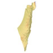
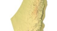
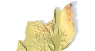
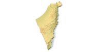
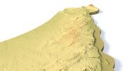
Israel 3D Topographic Map STL – High-Precision Relief Model for 3D Printing & CNC
$15.00
![]()
- File size: 125 MB
- Model size: 15 mm x 40 mm x 1 mm
- Projection: Mercator
- Coverage: Israel, Gaza Strip, surrounding territories
- Scaling factor: X — 0,001; Y — 0,001; Z — 0,003
- Polygons: 2 641 334
- Geometry: Polygonal Tris only
- Base: Closed
If you need a custom scale, projection, or modified version of this Israel 3D map, a personalized version can be created on request.
Israel 3D Topographic Map STL is a high-detail 3D relief model of Israel, including the Gaza Strip and occupied territories, designed for professional 3D printing and CNC carving. The model is created using digital elevation data and accurately represents real-world terrain, coastline geometry, and elevation changes with excellent geographic precision.
The file is supplied in STL format and features a watertight, optimized polygonal mesh, ensuring stable printing and machining without errors or additional preparation. The model is fully ready for use on FDM and SLA 3D printers, as well as CNC milling machines.


Key Features & Benefits
- Accurate Israel topographic map 3D with real elevation data
- Suitable for 3D printing and CNC carving
- Optimized STL mesh (watertight, manifold geometry)
- Easily scalable for different project sizes
- Compatible with popular slicer and CAM software
Applications
- Education & Research
Ideal as a physical teaching aid for geography, geology, and Middle Eastern studies in schools and universities. - Interior Design & Decor
Create striking wall-mounted relief maps and 3D panels for offices, classrooms, and creative spaces. - Souvenirs & Gifts
Perfect for producing unique map-based items, from desk models to decorative wall art. - Architecture & Design
Useful in architectural and landscape projects where an accurate Israel terrain 3D model is required. - Hobby & Jewelry Making
Well suited for creating pendants, charms, earrings, and custom jewelry shaped like the country.
FAQ
The description includes scaling factors for each axis. For example, if you see X – 0.001, Y – 0.001, Z – 0.003, this means the height is three times greater than the width and length. We scale height this way to emphasize the relief.
If you need uniform proportions, let us know—we’ll prepare a custom model upon request.
Send us your required specifications, and we’ll adapt the model accordingly.
Yes, we check every model for integrity and errors.
Yes. For better surface quality, we recommend printing it vertically.
Larger models require more polygons to preserve relief detail. Provide your desired dimensions, and we’ll prepare:
A single optimized model or
A segmented version with high resolution.
Yes, but polygon reduction may be necessary. Submit a request with your project’s dimensions for a tailored solution.