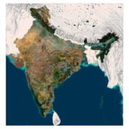
info@shustrik-maps.com

Contact me


    Free conversion to OBJ/FBX/STL/C4D
    • Services
    • About
    • FAQ
    • Site Map
    • How to buy?
    info@shustrik-maps.com

    Contact me


      Logo shustrik maps
      • 3D MODELSOBJ/FBX/C4D
        • Solar System

          3D MODELS OF SOLAR SYSTEM OBJECTS

          Planets (11)

          11 products

          Satellites (1)

          1 product

          Space objects (3)

          3 products
        • World

          World (8)

          8 products

          North Pole (1)

          1 product

          South Pole (1)

          1 product

          Fantasy (2)

          2 products
        • Continents

          North America (2)

          2 products

          South America (2)

          2 products

          Europe (2)

          2 products

          Asia (1)

          1 product

          Africa (2)

          2 products

          Oceania (3)

          3 products

          Antarctica (1)

          1 product
        • Peninsulas

          Peninsulas (1)

          1 product
        • Islands

          Islands (13)

          13 products
        • Countries

          All countries →

          3D MODELS OF THE COUNTRIES

          A | B | C | D | E | 

          F | G | H | I | J | 

          K | L | M | N | O | 

          P | Q | R | S | T | 

          U | V | W | Y | Z | 

          3D MODELS OF COUNTRIES BY CONTINENT

          NORTH AMERICA

          • Northern America
          • Central America
          • Caribbean

          SOUTH AMERICA

          EUROPE

          • Western Europe
          • Northern Europe
          • Southern Europe
          • Eastern Europe

          AFRICA

          • Eastern Africa
          • Middle Africa
          • Northern Africa
          • Southern Africa
          • Western Africa

          ASIA

          • Central Asia
          • Eastern Asia
          • Southeast Asia
          • Southern Asia
          • Western Asia
        • States of America

          All states →

          UNITED STATES 3D MODELS

          Alabama

          • C4D/OBJ/BLEND 
          • STL
          • Satellite Map

          Alaska

          • STL


          Arizona

          • C4D/OBJ/BLEND 
          • STL
          • Satellite Map

          Arkansas

          • C4D/OBJ/BLEND 
          • STL
          • Satellite Map

          California

          • Tex 1: C4D/OBJ
          • Tex 2: C4D/OBJ
          • STL
          • Satellite Map

          Colorado

          • C4D/OBJ/BLEND
          • STL
          • Satellite Map

          Connecticut

          • STL
          • Satellite Map

          Delaware

          • STL
          • Satellite Map

          Florida

          • C4D/OBJ/BLEND
          • STL
          • Satellite Map

          Georgia

          • STL
          • Satellite Map

          Hawaii

          • C4D/OBJ/BLEND
          • STL


          Idaho

          • C4D/OBJ/BLEND
          • STL
          • Satellite Map

          Illinois

          • STL
          • Satellite Map

          Indiana

          • C4D/OBJ/BLEND
          • STL
          • Satellite Map

          Iowa

          • C4D/OBJ/BLEND
          • STL
          • Satellite Map

          Kansas

          • C4D/OBJ/BLEND
          • STL
          • Satellite Map

          Kentucky

          • STL
          • Satellite Map

          Louisiana

          • STL
          • Satellite Map

          Maine

          • STL
          • Satellite Map

          Maryland

          • STL
          • Satellite Map

          Massachusetts

          • STL
          • Satellite Map

          Michigan

          • STL

          Minnesota

          • STL


          Mississippi

          • STL

          Missouri

          • STL

          Montana

          • Tex 1: C4D/OBJ
          • Tex 1: C4D/OBJ
          • STL

          Nebraska

          • C4D/OBJ/BLEND
          • STL


          Nevada

          • C4D/OBJ/BLEND
          • STL


          New Hampshire

          • STL


          New Jersey

          • STL

          New Mexico

          • C4D/OBJ/BLEND
          • STL

          New York

          • STL


          North Carolina

          • STL

          North Dakota

          • C4D/OBJ/BLEND
          • STL

          Ohio

          • STL


          Oklahoma

          • STL

          Oregon

          • C4D/OBJ/BLEND
          • STL

          Pennsylvania

          • STL


          Rhode Island

          • STL

          South Carolina

          • STL

          South Dakota

          • C4D/OBJ/BLEND
          • STL

          Tennessee

          • STL


          Texas

          • C4D/OBJ/BLEND
          • STL

          Utah

          • C4D/OBJ/BLEND
          • STL


          Vermont

          • STL


          Virginia

          • STL

          Washington

          • C4D/OBJ/BLEND
          • STL

          West Virginia

          • STL


          Wisconsin

          • STL

          Wyoming

          • C4D/OBJ/BLEND
          • STL
        • Canadian Provinces

          CANADIAN PROVINCES 3D MODELS

          Alberta

          British Columbia

          Manitoba

          New Brunswick

          Newfoundland

          Nova Scotia

          Ontario

          Prince Edward

          Quebec

          Saskatchewan

          CANADIAN TERRITORIES 3D MODELS

          Northwest Territories

          Nunavut

          Yukon

        • Parks & Canyons

          3D MODELS OF NATIONAL PARKS AND CANYONS

          Canyons (2)

          2 products
        • Other

          ART (4)

          4 products
      • 3D PRINT/CNC MODELSSTL
        • Planets
        • Satellites
        • Continents
        • Countries
        • Islands
        • States of America
        • Fantasy
        • Other
      • MAPSTIF/PSD/SVG
        • Satellite Maps
        • Night Satellite Map
        • Heightmaps/Raster DEM
        • Relief Maps
        • 3D Maps
        • Historical Maps
        • Outline Maps
      • FREE
      • SERVICES
      • A-Z
      Search
      0 items / $0.00
      Menu
      3D Models and 3D Maps
      0 items / $0.00
      India 3D map
      Satellite map of India
      India relief map
      India map
      Click to enlarge
      India 3D map
      Satellite map of India
      India relief map
      India map
      Home MAPS 3D Maps India 3d map
      North Korea 3D model
      North Korea 3D Model Terrain Map $35.00
      Back to products
      United Kingdom 3D map
      United Kingdom & Ireland 3d map $32.00

      India 3d map

      $32.00

      High-resolution India 3D Map in TIF format

      • Linear size: 84.6 x 84.6 cm
      • Pixel resolution: 100 MPx (10 000 px x 10 000 px)
      • File size: ~700 MB
      • Compression: No compression
      • Color Depth: 16 Bit/channel
      • Color model: RGB
      • Print resolution: 300 DPI
      • Projection: Mercator

      We accept VISA, Mastercard, ApplePay, GooglePay and other payment methods

      — OR —

      You can also purchase this product using MasterCard/Visa on
      RenderHub →  and 3Dexport →.

      SKU: SH_1781 Category: 3D Maps Tags: Countries, Mercator, Southern Asia, TIF
      Share:
      • Description
      Description

      Discover the mesmerizing beauty of India from a whole new perspective with our 3D map of India. Whether you’re a travel enthusiast, an educator, or simply passionate about geography, this skillfully crafted 3D map offers you an unprecedented journey into the heart of India.

      Key Features:

      1. Highly detailed: Our 3D map of India is highly accurate and captures all the details of India’s diverse topography, including the towering peaks of the Himalayas, the vast plains of the Gangetic basin, and the scenic coastline of the Arabian and Bay of Bengal.
      2. Geographical accuracy: It is a 3D map created based on accurate geographical data, however, to emphasize the beauty of the terrain we have slightly indented the rivers and lakes, and I have raised the mountains a bit. Otherwise, the terrain would be very flat.
      3. Educational Resource: Ideal for the classroom, it is an invaluable educational tool to help students and teachers visualize the geographical features of a country.
      4. Versatile Use: Whether you are planning a trip, studying geography, decorating your office, or enhancing a presentation, it is a versatile 3D map of India that can be used for a variety of purposes, both educational and decorative. Printed on high-quality materials, the 3D map of India is durable and visually appealing, making it an elegant addition to any home, office, or educational institution.

      The 3D map of India is a digital image designed to be printed on a flat surface. The highly detailed renderer allows the image to be printed on professional photo paper, metal (HD Metal Print), acrylic, and on walls using specialized equipment.

      India map

      Ideal For:

      • Classrooms: Enhance geography lessons, promote interactive learning, and stimulate students’ curiosity about the world by incorporating this 3D map into your teaching resources.
      • Travel Enthusiasts: Plan your next adventure or reminisce about past travels by exploring the diverse landscapes and cultural landmarks of India in three-dimensional detail.
      • Home Decor: Elevate your home decor with a unique conversation piece that showcases your love for exploration and cultural diversity.
      • Educational Institutions: Perfect for school libraries, geography departments, and educational exhibitions, this 3D map adds a touch of interactive learning to any educational space.

      Embark on a Visual Journey:

      Bring the wonders of India into your world with our India 3D Map. Whether you’re a teacher inspiring young minds, a traveler seeking your next destination, or an enthusiast fascinated by the beauty of our planet, this map is your passport to an immersive and educational exploration of one of the world’s most captivating countries. Purchase now and let your imagination soar across the landscapes of India’s rich history and breathtaking natural beauty.

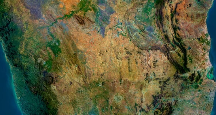
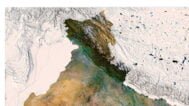
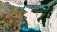
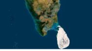
      India 3D Map at 100% zoom (Click to zoom in)

      India terrain

      Leave a request if you need an India 3D Map in other sizes, resolutions or projections.

      India 3D Model Terrain Map

      Related products

      Full 3D STL model of Azerbaijan showing terrain detail
      Azerbaijan elevation STL with detailed contour lines

      Azerbaijan Topographic Map – 3D Model for 3D Printing & CNC Carving

      $15.00
      Add to cart
      3D terrain model of Bangladesh in STL format, front view
      Close-up of Bangladesh’s river deltas in STL model

      Bangladesh Topographic Map – 3D Model for 3D Printing & CNC Carving

      $15.00
      Add to cart
      -19%
      Jordan STL model
      Jordan 3D model

      Jordan STL model

      $21.00 Original price was: $21.00.$17.00Current price is: $17.00.
      Add to cart
      -19%
      Kazakhstan STL model
      Kazakhstan 3D model

      Kazakhstan STL model

      $21.00 Original price was: $21.00.$17.00Current price is: $17.00.
      Add to cart
      -19%
      Kosovo STL model
      Kosovo 3D model

      Kosovo STL model

      $21.00 Original price was: $21.00.$17.00Current price is: $17.00.
      Add to cart
      -19%
      Kuwait STL model
      Kuwait 3D model

      Kuwait STL model

      $21.00 Original price was: $21.00.$17.00Current price is: $17.00.
      Add to cart
      France maps 3d
      3d relief map of France

      Relief map of France

      Read more
      Relief map of Slovakia
      mapa 3d Slovakia

      Relief map of Slovakia

      Read more
      Relief map of Taiwan
      mapa 3d Taiwan

      Relief map of Taiwan

      Read more
      Relief map of Ukraine
      mapa 3d Ukraine

      Relief map of Ukraine

      Read more
        INFO
        • About
        • Explore Our Terrain Services
        • Support
        • Shipping and delivery policy
        • Refund and Returns Policy
        • Privacy Policy
        • in**@***********ps.com
        • Blog
        How to buy
        • TERRAIN 3D MODELS FREE
        • Purchase with Crypto/PayPal/VISA
        • Buy on Cults3D.com
        • Buy on CGtrader.com
        • Buy on RenderHub.com
        • Buy on 3DExport.com
        • Discounts
        Buy 3D models
        • Planets
        • World
        • Continents
        • Peninsulas
        • Islands
        • Countries
        • States of America
        • Canadian Provinces
        • Canyons
        • Cities
        • Fantasy
        • Minecraft
        Buy 3D models for CNC
        • Planets
        • Continents
        • Islands
        • Countries
        • States of America

        DEM DSM DTM FBX OBJ STL

        SHUSTRIK-MAPS 2025
        • 3D MODELS
        • 3D PRINT/CNC MODELS
        • MAPS
        • FREE
        • About
        • FAQ
        • How to buy?
        • Site Map HTML
        • Explore Our Terrain Services
        Shopping cart
        Close
        Start typing to see products you are looking for.
        Your amount to pay has been updated
        The previous conversion quote has expired. Here is your new quote:
        Total
        $
        You Pay
        Back to checkout
        Place Order