Dominican Republic Topographic Map – 3D Model for 3D Printing & CNC Carving
$15.00
High-polygon 3D model of the Dominican Republic in STL format
![]()
- File size: 96 MB
- Model size: 200 mm x 140 mm x 4 mm
- Projection: Mercator
- Scaling factor: X — 0,001; Y — 0,001; Z — 0,0025
- Polygons: 2 011 382
- Vertices: 1 005 765
- Geometry: Polygonal Tris only
- Base: Closed
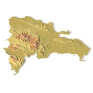
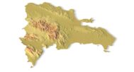
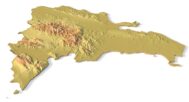
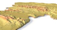
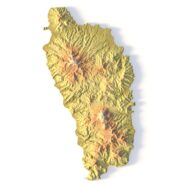
The Dominican Republic Topographic Map is a high-resolution 3D terrain model based on an accurate digital elevation model (DEM). It faithfully represents the country’s diverse landscapes, including the Cordillera Central mountain range, lush valleys, coastal plains, and iconic beaches, making it an excellent choice for designers, educators, cartographers, and geography enthusiasts.
This STL file is fully compatible with FDM and SLA 3D printers, as well as CNC routers. You can 3D print a realistic map of the Dominican Republic in plastic or CNC carve it from wood, metal, or resin. It’s ideal for:
✔ Educational models (geography & history lessons)
✔ Souvenir & gift production (personalized travel keepsakes)
✔ Landscape & architectural projects (terrain visualization)
✔ Artistic displays & wall decorations
With precise elevation modeling and high visual fidelity, this 3D map brings the Dominican Republic’s landscapes to life. Every mountain, river, and coastline is carefully detailed for a professional and realistic finish.


Why Choose This Model?
✅ True-to-Life Topography – Based on geospatial DEM data for accuracy.
✅ Optimized for 3D Printing & CNC – Clean STL file works with PLA, resin, wood, aluminum, and more.
✅ Versatile Use Cases – Great for education, design projects, souvenirs, and décor.
Sample Use Cases:
3D print a raised-relief map for geography or history classes
CNC carve the Cordillera Central mountains into wood for a wall art piece
Create a tourist souvenir showcasing Punta Cana’s coastline
Design a custom topographic keychain or jewelry
Use in architectural models for terrain-aware planning