Australia Topographic Map STL– 3D Model for 3D Printing & CNC Carving
$15.00
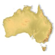
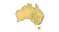
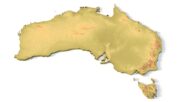
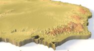
Detailed Terrain STL Model of Australia’s Diverse Landscapes
![]()
- File size: 126 MB
- Model size: 218 mm x 210 mm x 2.9 mm
- Projection: Mercator
- Scaling factor: X — 0,001; Y — 0,001; Z — 0,005
- Polygons: 2 650 441
- Vertices: 1 326 188
- Geometry: Polygonal Tris only
- Base: Closed
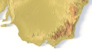
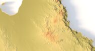
Explore Australia’s vast and varied landscapes with our high-resolution Australia Topographic Map STL Model. This meticulously crafted 3D model captures the country’s stunning geographical diversity—from the rugged Great Dividing Range and the arid Outback to the sweeping coastlines and lush rainforests. Perfect for relief maps, educational projects, and creative designs, this model provides accurate elevation data and precise landform analysis of Australia’s terrain.
Applications of the Australia Topographic STL Model
3D Printing: Create physical models of Australia’s terrain using FDM or SLA 3D printers, showcasing elevation variations from Uluru to the Australian Alps.
CNC Machining: Ideal for crafting detailed relief maps from wood, metal, or acrylic, with precision-cut contours for professional and artistic use.
Laser Engraving: Perfect for high-precision engravings on metals or wood, capturing Australia’s unique topography in intricate detail.
Detailed Terrain Representation for Education & Professional Use
This digital elevation model (DEM) of Australia provides accurate geographic data, making it a valuable tool for:
Researchers & Educators – Study Australia’s landforms, river systems, and elevation changes.
Designers & Architects – Incorporate realistic terrain into 3D site models or landscape designs.
Hobbyists & Artists – Create stunning 3D art, custom souvenirs, or geography-themed displays.


Why Choose This Australia STL Terrain Map?
✔ Highly detailed – Captures deserts, mountains, and coastlines with precision.
✔ Scalable – Printable and carveable in various sizes and materials.
✔ Ready-to-use – No additional processing needed for 3D printing or CNC carving.
✔ Versatile – Perfect for educational, artistic, and professional projects.
Sample Use Cases
Print a classroom model of Australia’s terrain for geography lessons.
CNC-carve a wooden relief map showcasing the Great Barrier Reef or the Simpson Desert.
Laser-engrave a metal plaque of Australia’s topographic contours.
Design elevation-aware architectural models for urban planning or environmental studies.
Create unique 3D-printed souvenirs for travelers and geography enthusiasts.
FAQ
The description includes scaling factors for each axis. For example, if you see X – 0.001, Y – 0.001, Z – 0.003, this means the height is three times greater than the width and length. We scale height this way to emphasize the relief.
If you need uniform proportions, let us know—we’ll prepare a custom model upon request.
Send us your required specifications, and we’ll adapt the model accordingly.
Yes, we check every model for integrity and errors.
Yes. For better surface quality, we recommend printing it vertically.
Larger models require more polygons to preserve relief detail. Provide your desired dimensions, and we’ll prepare:
A single optimized model or
A segmented version with high resolution.
Yes, but polygon reduction may be necessary. Submit a request with your project’s dimensions for a tailored solution.