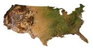
info@shustrik-maps.com

Contact me


    Free conversion to OBJ/FBX/STL/C4D
    • Services
    • About
    • FAQ
    • Site Map
    • How to buy?
    info@shustrik-maps.com

    Contact me


      Logo shustrik maps
      • 3D MODELSOBJ/FBX/C4D
        • Solar System

          3D MODELS OF SOLAR SYSTEM OBJECTS

          Planets (11)

          11 products

          Satellites (1)

          1 product

          Space objects (3)

          3 products
        • World

          World (6)

          6 products

          North Pole (1)

          1 product

          South Pole (1)

          1 product

          Fantasy (2)

          2 products
        • Continents

          North America (2)

          2 products

          South America (2)

          2 products

          Europe (2)

          2 products

          Asia (1)

          1 product

          Africa (2)

          2 products

          Oceania (3)

          3 products

          Antarctica (1)

          1 product
        • Peninsulas

          Peninsulas (1)

          1 product
        • Islands

          Islands (13)

          13 products
        • Countries

          All countries →

          3D MODELS OF THE COUNTRIES

          A | B | C | D | E | 

          F | G | H | I | J | 

          K | L | M | N | O | 

          P | Q | R | S | T | 

          U | V | W | Y | Z | 

          3D MODELS OF COUNTRIES BY CONTINENT

          NORTH AMERICA

          • Northern America
          • Central America
          • Caribbean

          SOUTH AMERICA

          EUROPE

          • Western Europe
          • Northern Europe
          • Southern Europe
          • Eastern Europe

          AFRICA

          • Eastern Africa
          • Middle Africa
          • Northern Africa
          • Southern Africa
          • Western Africa

          ASIA

          • Central Asia
          • Eastern Asia
          • Southeast Asia
          • Southern Asia
          • Western Asia
        • States of America

          All states →

          UNITED STATES 3D MODELS

          Alabama

          • C4D/OBJ/BLEND 
          • STL
          • Satellite Map

          Alaska

          • STL


          Arizona

          • C4D/OBJ/BLEND 
          • STL
          • Satellite Map

          Arkansas

          • C4D/OBJ/BLEND 
          • STL
          • Satellite Map

          California

          • Tex 1: C4D/OBJ
          • Tex 2: C4D/OBJ
          • STL
          • Satellite Map

          Colorado

          • C4D/OBJ/BLEND
          • STL
          • Satellite Map

          Connecticut

          • STL
          • Satellite Map

          Delaware

          • STL
          • Satellite Map

          Florida

          • C4D/OBJ/BLEND
          • STL
          • Satellite Map

          Georgia

          • STL
          • Satellite Map

          Hawaii

          • C4D/OBJ/BLEND
          • STL


          Idaho

          • C4D/OBJ/BLEND
          • STL
          • Satellite Map

          Illinois

          • STL
          • Satellite Map

          Indiana

          • C4D/OBJ/BLEND
          • STL
          • Satellite Map

          Iowa

          • C4D/OBJ/BLEND
          • STL
          • Satellite Map

          Kansas

          • C4D/OBJ/BLEND
          • STL
          • Satellite Map

          Kentucky

          • STL
          • Satellite Map

          Louisiana

          • STL
          • Satellite Map

          Maine

          • STL
          • Satellite Map

          Maryland

          • STL
          • Satellite Map

          Massachusetts

          • STL
          • Satellite Map

          Michigan

          • STL

          Minnesota

          • STL


          Mississippi

          • STL

          Missouri

          • STL

          Montana

          • Tex 1: C4D/OBJ
          • Tex 1: C4D/OBJ
          • STL

          Nebraska

          • C4D/OBJ/BLEND
          • STL


          Nevada

          • C4D/OBJ/BLEND
          • STL


          New Hampshire

          • STL


          New Jersey

          • STL

          New Mexico

          • C4D/OBJ/BLEND
          • STL

          New York

          • STL


          North Carolina

          • STL

          North Dakota

          • C4D/OBJ/BLEND
          • STL

          Ohio

          • STL


          Oklahoma

          • STL

          Oregon

          • C4D/OBJ/BLEND
          • STL

          Pennsylvania

          • STL


          Rhode Island

          • STL

          South Carolina

          • STL

          South Dakota

          • C4D/OBJ/BLEND
          • STL

          Tennessee

          • STL


          Texas

          • C4D/OBJ/BLEND
          • STL

          Utah

          • C4D/OBJ/BLEND
          • STL


          Vermont

          • STL


          Virginia

          • STL

          Washington

          • C4D/OBJ/BLEND
          • STL

          West Virginia

          • STL


          Wisconsin

          • STL

          Wyoming

          • C4D/OBJ/BLEND
          • STL
        • Canadian Provinces

          CANADIAN PROVINCES 3D MODELS

          Alberta

          British Columbia

          Manitoba

          New Brunswick

          Newfoundland

          Nova Scotia

          Ontario

          Prince Edward

          Quebec

          Saskatchewan

          CANADIAN TERRITORIES 3D MODELS

          Northwest Territories

          Nunavut

          Yukon

        • Parks & Canyons

          3D MODELS OF NATIONAL PARKS AND CANYONS

          Canyons (2)

          2 products
        • Other

          ART (5)

          5 products
      • 3D PRINT/CNC MODELSSTL
        • Planets
        • Satellites
        • Continents
        • Countries
        • Islands
        • States of America
        • Fantasy
        • Other
      • MAPSTIF/PSD/SVG
        • Satellite Maps
        • Night Satellite Map
        • Heightmaps/Raster DEM
        • Relief Maps
        • 3D Maps
        • Historical Maps
        • Outline Maps
      • FREE
      • SERVICES
      • A-Z
      Search
      0 items / $0.00
      Menu
      3D Models and 3D Maps
      0 items / $0.00
      USA 3D map model showcasing elevation and topographic details.
      USA map in 3D with elevation, normal maps, and satellite textures.
      3D relief map of USA showing high-polygon modeling for design projects.
      High-resolution 3D topographic map of the USA with detailed textures.
      3D model of the United States showing terrain elevation and relief.
      USA 3D elevation model
      Map of USA
      United States 3D Print model
      United States model C4D OBJ STL
      United States terrain
      Topographic map United States
      Map of United States
      United States 3D elevation model
      United States relief map
      United States 3D map
      United States buy 3d models
      United States 3D model
      United States terrain 3D model
      Click to enlarge
      USA 3D map model showcasing elevation and topographic details.
      USA map in 3D with elevation, normal maps, and satellite textures.
      3D relief map of USA showing high-polygon modeling for design projects.
      High-resolution 3D topographic map of the USA with detailed textures.
      3D model of the United States showing terrain elevation and relief.
      USA 3D elevation model
      Map of USA
      United States 3D Print model
      United States model C4D OBJ STL
      United States terrain
      Topographic map United States
      Map of United States
      United States 3D elevation model
      United States relief map
      United States 3D map
      United States buy 3d models
      United States 3D model
      United States terrain 3D model
      Home 3D MODELS Countries USA map 3D model
      Ukraine 3D model
      Ukraine map 3D model $28.00
      Back to products
      New Zealand terrain 3D model
      New Zealand Elevation 3D Model $28.00

      USA map 3D model

      $28.00

      3D Model

      • Format: C4D (export to OBJ/FBX on request)
      • File size: 1.07 GB
      • Polygons: 19 272 828
      • Vertices: 9 663 688
      • Geometry: Polygonal Tris only
      • Model size: 453.199 mm x 283.477 mm x 8.903 mm
      • Projection: Albers Conic
      • Base: Open

      Texture

      • Format: TIF
      • File size: 284 MB
      • Resolution: 6000*6000*48b
      • Type: Multi-layer (you can easily change the texture in Photoshop)
      • UV layer: yes

      We accept VISA, Mastercard, ApplePay, GooglePay and other payment methods

      — OR —

      You can also purchase this product using MasterCard/Visa on
      RenderHub →  and 3Dexport →.

      SKU: SH_1283 Category: Countries Tags: Albers Conic, C4D, Northern America, U, USA
      Share:
      • Description
      Description

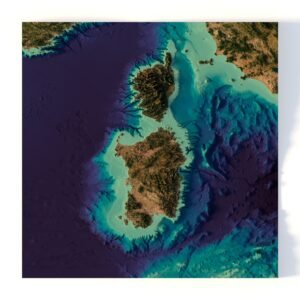
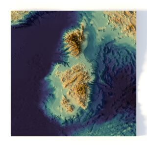
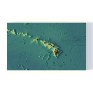
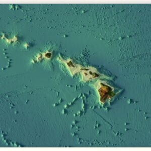
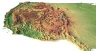
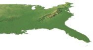
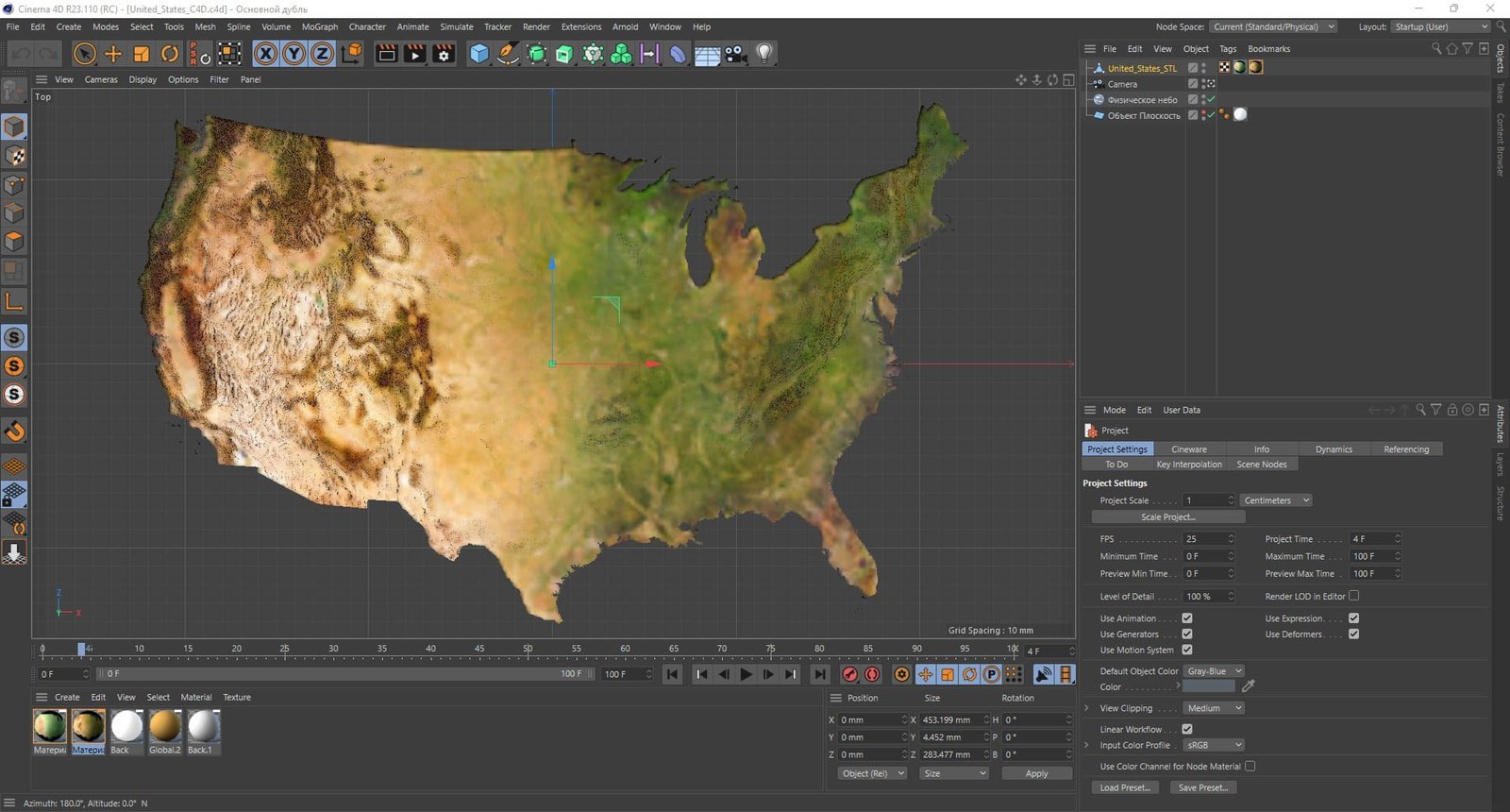
      Overview of the USA 3D Map Model

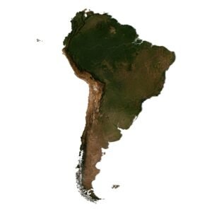
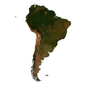
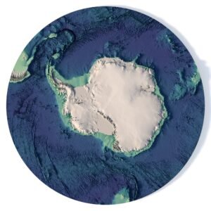
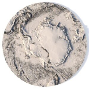
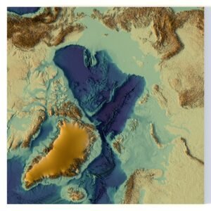
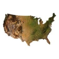
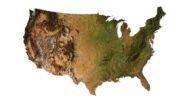
      Our 3D map model of the USA is the perfect solution for graphic design, educational projects and creative works. This highly detailed map includes a satellite texture and a pseudo-color map where color is associated with elevation.
      The model contains a UV layer that provides accurate texture mapping for realistic results when used in design or presentations.

      Key Features of the USA Map in 3D

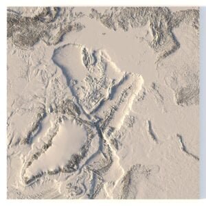
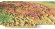
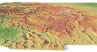
      • High-resolution relief map: Contains detailed topographic data of the entire United States.
      • Multiple Texture Support: Apply satellite and DEM textures to show different geographic aspects.
      • 3D elevation and elevation models: Ideal for those who need an accurate 3D relief map of the United States.
      • Customizable for your projects: This map is suitable for 3D modeling, architectural visualization and educational purposes.
      United States Cinema 4D

      Versatile Formats and Usability

      This 3D map of the USA can be used in a variety of projects, including those that require a 3D US relief map or topographic maps. Formats such as OBJ, FBX, and STL are available upon request to ensure compatibility with your software. In addition, the number of polygons in the model can be reduced to meet the performance requirements of your project.

      Applications for the 3D USA Map

      • Graphic designers: Use 3D map of the USA for creative projects, marketing materials or presentations.
      • Educators and students: Integrate the 3D topographic map of the United States into educational modules on geology, geography, and environmental science.
      • Architects and urban planners: Plan projects or demonstrate designs with this 3D terrain model of the United States.

      In addition to the 3D terrain model of the USA, I can attach a map of heights, shape-files and various satellite textures.
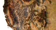
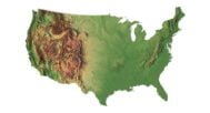
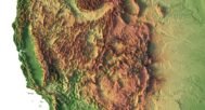
      USA DEM

      United States DEM

      The elevation map is used to get information about low and high parts of the USA relief.
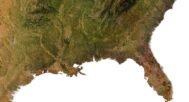
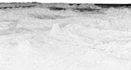
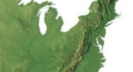
      Shapefile of USA

      United States Shapefile

      The shapefile is used to cut the 3D model along the contour.

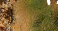
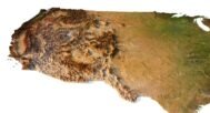
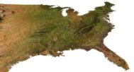
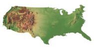
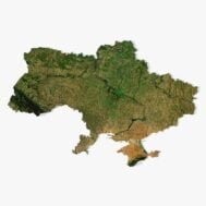
      Satellite image of USA

      United States Texture

      The satellite texture is high resolution in TIF format.

      FAQ

      Can I get this map in a different projection?

      Yes, we offer custom projections upon request. Contact us for details.

      What formats can the 3D USA map model be provided in?

      The model can be exported in multiple formats such as OBJ, FBX, and STL, ensuring compatibility with most 3D software.

      Is it possible to reduce the polygon count of the 3D USA map?

      Yes, we can optimize the model by reducing the number of polygons, tailoring it to your project's performance needs and budget.

      I need a custom size or additional features. What should I do?

      For custom sizes or additional features, please contact us directly. We are happy to work with you to create a tailored map that fits your specific needs.

      If you have any other questions or special requests, feel free to get in touch with us. We’re here to help!

      United States 3D Model Terrain
      50 United States of America 3D Model
      Contiguous 48 USA States 3D Model

      Related products

      South America terrain 3D model
      South America 3D model

      3D map of South America C4D model

      $28.00
      Add to cart
      Africa terrain 3D model
      Africa 3D model

      Africa 3D Model

      $28.00
      Add to cart
      Antarctica terrain 3D model
      Antarctica terrain 3D model

      Antarctica Elevation Map 3D Model

      $28.00
      Add to cart
      -33%
      Grand Canyon 3D model
      A detailed 3D overview of the Grand Canyon, showcasing topographical features and natural landscape.

      Grand Canyon 3D model

      $30.00 Original price was: $30.00.$20.00Current price is: $20.00.
      Add to cart
      -33%
      Greenland 3D model without water
      Greenland STL model

      Greenland terrain without water 3D model

      $30.00 Original price was: $30.00.$20.00Current price is: $20.00.
      Add to cart
      New Zealand terrain 3D model
      3D model of New Zealand’s elevation, showcasing detailed topography for graphic design and educational use.

      New Zealand Elevation 3D Model

      $28.00
      Add to cart
      North America terrain 3D model
      North America 3D model

      North America 3D model

      $28.00
      Add to cart
      France 3D model
      France relief map

      Relief map of France 3D model

      $28.00
      Add to cart
      -33%
      California 3D model
      California buy 3d models

      Relief map of the state of California 3D model

      $30.00 Original price was: $30.00.$20.00Current price is: $20.00.
      Add to cart
      World terrain 3D model
      World 3D model

      World Map 3D Model

      $28.00
      Add to cart
        INFO
        • About
        • Explore Our Terrain Services
        • Support
        • Shipping and delivery policy
        • Refund and Returns Policy
        • Privacy Policy
        • in**@***********ps.com
        • Blog
        How to buy
        • TERRAIN 3D MODELS FREE
        • Purchase with Crypto/PayPal/VISA
        • Buy on Cults3D.com
        • Buy on CGtrader.com
        • Buy on RenderHub.com
        • Buy on 3DExport.com
        • Discounts
        Buy 3D models
        • Planets
        • World
        • Continents
        • Peninsulas
        • Islands
        • Countries
        • States of America
        • Canadian Provinces
        • Canyons
        • Cities
        • Fantasy
        • Minecraft
        Buy 3D models for CNC
        • Planets
        • Continents
        • Islands
        • Countries
        • States of America

        DEM DSM DTM FBX OBJ STL

        SHUSTRIK-MAPS 2025
        • 3D MODELS
          • Solar System
          • World
          • Continents
          • Peninsulas
          • Islands
          • Countries
          • States of America
          • Canadian Provinces
          • Canyons
          • Buildings
          • Fantasy
          • ART
        • 3D PRINT/CNC MODELS
          • Planets
          • Satellites
          • Continents
          • Countries
          • Islands
          • States of America
          • Fantasy
          • Other
        • MAPS
        • A-Z
        • FREE
        • About
        • FAQ
        • How to buy?
        • Site Map HTML
        • Explore Our Terrain Services
        Shopping cart
        Close
        Start typing to see products you are looking for.
        Your amount to pay has been updated
        The previous conversion quote has expired. Here is your new quote:
        Total
        $
        You Pay
        Back to checkout
        Place Order