

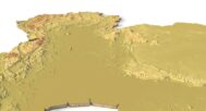


Thailand Topographic Map – 3D Model for 3D Printing & CNC Carving
$15.00
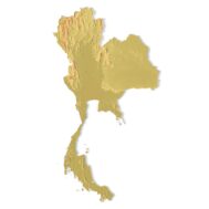
High-polygon 3D model of Thailand in STL format
![]()
- File size: 122 MB
- Model size: 120 mm x 220 mm x 1.4 mm
- Projection: Mercator
- Scaling factor: X — 0,001; Y — 0,001; Z — 0,003
- Polygons: 2 558 924
- Vertices: 1 279 642
- Geometry: Polygonal Tris only
- Base: Closed
The Thailand Topographic Map is a high-resolution 3D terrain model based on accurate digital elevation data (DEM). It captures Thailand’s diverse landscapes—from the northern mountains to the central plains and southern coastlines—making it perfect for designers, educators, cartographers, and geography enthusiasts.
This STL file is fully compatible with FDM & SLA 3D printers and CNC routers. Print it in plastic, resin, or carve it from wood/metal for educational models, souvenirs, landscape projects, or terrain visualization.
Whether for classroom learning, architectural planning, or artistic displays, this model delivers precise elevation details and stunning realism, bringing Thailand’s geography to life.


Why Choose This Model?
✔ Realistic Topography – Based on geospatial DEM data for accuracy.
✔ Ready for 3D Printing & CNC – Optimized STL file for PLA, resin, wood, and metal.
✔ Versatile Applications – Great for education, design, souvenirs, and decor.
Sample Use Cases:
3D print a raised-relief map of Thailand for geography lessons.
CNC carve Thailand’s terrain into wood or metal for wall art.
Create architectural terrain models for landscape planning.
Design custom souvenirs, jewelry, or display pieces.
FAQ
The description includes scaling factors for each axis. For example, if you see X – 0.001, Y – 0.001, Z – 0.003, this means the height is three times greater than the width and length. We scale height this way to emphasize the relief.
If you need uniform proportions, let us know—we’ll prepare a custom model upon request.
Send us your required specifications, and we’ll adapt the model accordingly.
Yes, we check every model for integrity and errors.
Yes. For better surface quality, we recommend printing it vertically.
Larger models require more polygons to preserve relief detail. Provide your desired dimensions, and we’ll prepare:
A single optimized model or
A segmented version with high resolution.
Yes, but polygon reduction may be necessary. Submit a request with your project’s dimensions for a tailored solution.