


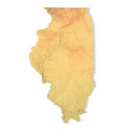
Indiana Topographic Map STL – 3D Terrain Model for 3D Printing & CNC
Original price was: $21.00.$15.00Current price is: $15.00.
![]()
- File size: 137 MB
- Model size: 200 mm x 143.4145 mm x 3 mm
- Projection: Mercator
- Scaling factor: X — 1; Y — 1; Z — 3
- Polygons: 2 874 192
- Vertices: 1 437 100
- Geometry: Polygonal Tris only
- Base: Closed
Indiana Topographic Map STL – High-Resolution 3D Terrain Model
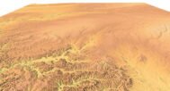
Indiana Topographic Map STL is a high-detail 3D terrain model generated from accurate elevation data and optimized for 3D printing, CNC carving, and laser engraving. The model accurately represents Indiana’s varied relief, including plains, river valleys, glacial landforms, and subtle elevation transitions, making it suitable for professional, educational, and creative applications.
This Indiana terrain STL model is provided in standard STL format and is fully compatible with FDM and SLA 3D printers, as well as CNC routers and milling machines. Enhanced vertical scaling is applied to ensure that low-relief terrain features remain clearly visible in physical topographic maps, delivering a clean and readable representation.
Key Features of the Indiana Terrain STL Model
- High-detail Indiana topographic map STL
- Accurate digital elevation model (DEM)
- Optimized for 3D printing (FDM / SLA)
- Ready for CNC carving and milling
- Suitable for laser engraving
- Mercator projection for consistent geometry
- Triangle-only polygonal mesh
- Open or closed base configuration
Applications of the Indiana 3D Topographic Map
This Indiana 3D terrain model can be applied across a broad range of use cases:
- Raised topographic relief maps
- CNC-carved wooden or metal terrain models
- Educational geography and earth science projects
- Hydrological and watershed visualization
- Land-use and infrastructure planning models
- Museum exhibits and presentation displays
- Decorative wall maps and custom interior elements
Whether you are producing a 3D printed Indiana map, a CNC terrain model, or a laser-engraved relief, this STL file ensures professional accuracy and consistent manufacturing results.