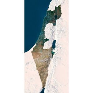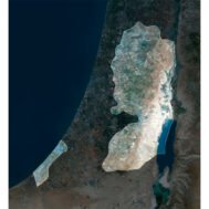
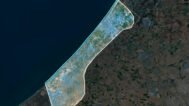
Palestine Satellite Map
$15.00
Buy Palestine Satellite Map – Ideal for Education, Decor, and Gifts
- Format: TIF
- Resolution: 5100*5541 px
- Depth: 24 bit
- Size: 31 MB
- Color scheme: RGB
- Projection: Mercator
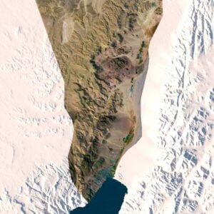
Experience the stunning beauty of Palestine like never before with our Palestine Satellite Map. This meticulously crafted digital map provides an intricate view of Palestine’s topography, captured through high-resolution satellite imagery. Whether you’re an educator, a design enthusiast, or a map lover, this map offers exceptional versatility and detail for a wide range of uses.
Key Features:
- High-Resolution Detail: Our Palestine Satellite Map boasts an exceptionally high resolution, allowing you to see every nuance of Palestine’s landscape. From urban areas to natural terrains, the map provides a clear and precise view of the region’s features.
- Versatile Applications: This map is ideal for multiple uses:
- Educational Tool: Use it to teach students about geography, geology, and environmental science. The detailed Palestine satellite images help in understanding the region’s terrain, land use, and natural features.
- Decorative Piece: Transform your space with a visually striking map that adds a touch of sophistication to any room. Perfect for framing and displaying in homes, offices, or educational institutions.
- Custom Projects: Easily integrate this Palestine satellite view into custom designs for posters, presentations, or digital displays. Its high quality ensures that it maintains clarity and detail in various formats and sizes.
- Unique Gift: A thoughtful and distinctive gift for cartography enthusiasts, travelers, or anyone who appreciates detailed geographical representations.
Enhance your understanding and appreciation of Palestine with this exceptional satellite map. Its precision, clarity, and versatility make it an invaluable resource for education, decor, and personal enjoyment. Don’t miss out on this opportunity to bring a piece of Palestine’s geography into your life.
FAQ
This map is not geo-referenced, but feel free to contact us to obtain a file with geo data if needed.
Yes, we offer custom projections upon request. Contact us for details.
Yes, if you need the map in a different file format, please contact us. We offer various formats to meet your needs.
Yes, of course. Please specify the desired 3D model format, dimensions and how you will use it. This will help me to prepare an optimal model for you.
Absolutely! If you require a higher resolution version, just let us know, and we can provide a version that fits your requirements.
Yes, we can customize the map with different projections or remove boundaries as needed. Please reach out to us with your specifications, and we’ll accommodate your request.
For custom sizes or additional features, please contact us directly. We are happy to work with you to create a tailored map that fits your specific needs.
Absolutely! The map is available in high resolution, making it suitable for large format printing without losing detail. Be sure to check with your printing company if they require RGB-to-CMYK color conversion for best results.
In addition to educational and decorative uses, the map can be utilized for trip planning, natural resource research, and as a creative gift.
Related products