Explore Our Terrain Services
Hight-Resolution
3D MODELS
Whether you’re captivated by the rugged beauty of canyons, the tranquility of parks and lakes, the awe-inspiring presence of volcanoes, or the uniqueness of islands, peninsulas, countries, continents, and even entire planets, we’ve got you covered!
Order your bespoke 3D model today and experience the wonder of lifelike terrain representation like never before. Elevate your perspective with us!
We offering a wide range of formats to suit your creative needs. From the popular STL format that’s widely compatible with 3D printers, to the professional-grade C4D, FBX, OBJ and Blender formats that cater to the most discerning designers, we ensure that our models seamlessly integrate into your creative workflows.
Preparation of 3D Models for
MILLING ON A CNC MACHINE
Do you need to create a high quality relief in wood, plastic or metal? We can help you.
1. Creation of Detailed 3D Models: Preparation of high-quality 3D models in STL or OBJ formats for milling.
2. Checking and customizing files in software products such as Aspire and ArtCAM.
3. Providing files in formats compatible with CNC machines (e.g. .crv3d, .art) as well as G-code.
4. Ability to visualize the milling process through video simulations, which helps customers understand what they will receive prior to purchase.
Preparation of 3D Models for
PRINTING ON A 3D PRINTER
It solves the tasks of preparing and adapting 3D models for different types of 3D printing, guaranteeing the quality and accuracy of the printed objects. The service includes the following aspects:
1. 3D Model Creation and Adaptation: We prepare files for 3D printing in STL format, ensuring their high quality and compatibility with different types of 3D printers (FDM, SLA).
2. Technical Check: All models are thoroughly checked on slicers for FDM and SLA 3D printers to ensure correct printing and prevent potential problems in the process.
3. Compatibility Problem Solving: Given that 3D printing programs are more demanding on input files than CNC programs, our service ensures problem-free model printing.
High-Quality
HEIGHT MAPS
The service includes the preparation of 16 or 32 bit height maps of different regions of the world, continents, individual countries or regions in different resolutions.
– Maps with high accuracy of relief detail, useful in geography, geology, construction and landscape design.
– Ability to select map projection and resolution depending on project needs – from 30 m to 1 m.
– Relief modification – adding rivers, lakes, additional mountains or plains.
High-Quality 3D Models & 3D Maps
RENDERINGS
The service offers the creation of terrain images from different angles for those who do not work with 3D programs. It solves the problems of:
1. Obtaining Terrain Visualization: Creating high-resolution renderings to visually represent terrain and landscapes.
2. Preparing for Printing: Providing services to prepare files for plotter printing in RGB and CMYK color schemes, which is useful for printing large images or posters.
In this way, clients receive quality terrain images for a variety of purposes including presentations, printing and graphic design.
High-Resolution
HISTORICAL MAPS
The service involves adding 3D relief to historical maps. It solves the following problems:
1. Revitalizing Historical Maps: Transforming old maps, breathing new life into them by adding 3D relief.
2. Improving Quality: Eliminating artifacts, correcting color, and improving overall image quality.
3. Adaptation for Modern Needs: Providing maps in modern RGB and CMYK color schemes, which is convenient for printing and digitalization.
It offers a unique way to preserve historical heritage by converting old maps into updated, high quality images suitable for a wide range of applications.
High-Resolution
SATELLITE TEXTURES
The service includes preparation of various satellite and topographic textures with 30m, 10m, 5m resolution. It solves the following tasks:
1. Provision of Accurate Textures: Selection and provision of the best satellite images from a variety of sources, including both free and paid resources.
2. Flexibility in Resolution Selection: Ability to order textures with different levels of detail depending on project requirements.
3. Suitable for a Wide Range of Applications: It can be used in geography, cartography, urban planning, landscape design and other areas where accurate and detailed satellite images are required.
Thus, the service provides customers with high quality satellite textures suitable for a variety of professional and scientific purposes.
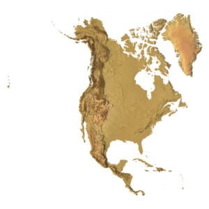
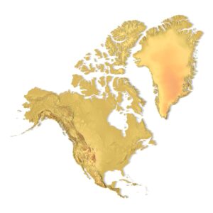
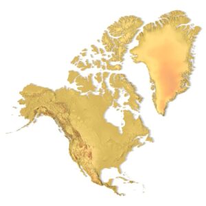
Various
MAP PROJECTIONS
There are many projections and for each region it is better to use a different projection so that the relief contours are with minimal distortion.
We can help you choose the right projection for your project.
Compare the Lambert Conformal Conic and Mercator projection for the North America model:

Maximum resolution
3D MODELS FROM GOOGLE EARTH
The service offers importing 3D models from Google Earth to create compelling 3D images for projects. It solves the following tasks:
1. Creating Shared Scenes: Suitable for creating shared scenes where the detail of the model geometry is not key.
2. Add Own Objects: The ability to integrate imported models with your own objects to create unique scenes.
3. Flexible Formats: Providing models in a variety of formats including OBJ, FBX, Blend, STL, C4D to meet the needs of different programs and projects.
It is ideal for projects that require the creation of visual materials based on real geographic data with moderate accuracy and detail requirements.